File:Shan jing Shu dao tu LOC gm71005016-10.tif

Size of this JPG preview of this TIF file: 800 × 166 pixels. Other resolutions: 320 × 66 pixels | 640 × 132 pixels | 1,024 × 212 pixels | 1,280 × 265 pixels | 2,560 × 530 pixels | 18,757 × 3,883 pixels.
Original file (18,757 × 3,883 pixels, file size: 208.38 MB, MIME type: image/tiff)
Captions
Captions
Add a one-line explanation of what this file represents
Summary
edit| Description |
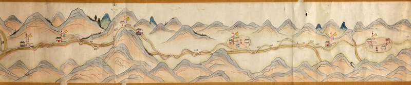
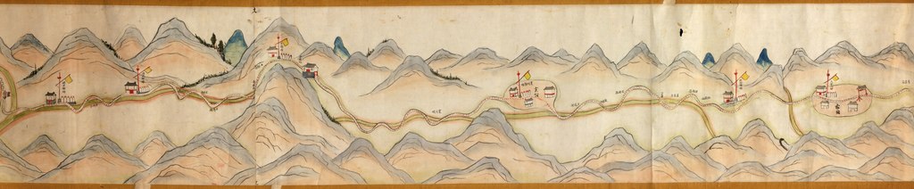
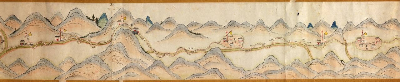
English: Scale ca. 1:16,000. Title supplied. Oriented with north to the right. Relief shown pictorially. Bird's-eye-view. Covers Wei River in Baoji Xian, Shanxi Sheng to "Shu Dao" in Shanxi-Sichuan border. Shows settlements, rest stops, stations, inns, temples, mountain passes, walled cities, bridges, and scenic areas along "Shu Dao". Available also through the Library of Congress Web site as a raster image. Purchase; Arthur William Hummel; 1930, no. 16. Previous call number: G7823.S3P2 1820 .S4 Vault Shelf AACR2 |
||
| Title | [Shan jing Shu dao tu] | ||
| Shelf ID | G7823.S3P2 1750 .S4 | ||
| Parent | https://www.loc.gov/resource/g7823sm.gct00272/ | ||
| Sheet title | Image 10 of [Shan jing Shu dao tu] | ||
| Date | |||
| Source | https://www.loc.gov/item/gm71005016/ | ||
| Author | Hummel, Arthur W. (Arthur William) | ||
| Permission (Reusing this file) |
|
||
| Other versions |
|
||
| Location | China · Shaanxi Sheng · Sichuan Sheng | ||
| Part of | American Memory · General Maps · Catalog · Geography And Map Division | ||
| Subject | Aerial Views · Sichuan Sheng (China) · Shaanxi Sheng · Maps · China · Manuscript Maps · Roads · Sichuan Sheng · Shaanxi Sheng (China) |

Licensing
edit|
This is a faithful photographic reproduction of a two-dimensional, public domain work of art. The work of art itself is in the public domain for the following reason:
The official position taken by the Wikimedia Foundation is that "faithful reproductions of two-dimensional public domain works of art are public domain".
This photographic reproduction is therefore also considered to be in the public domain in the United States. In other jurisdictions, re-use of this content may be restricted; see Reuse of PD-Art photographs for details. | ||||
File history
Click on a date/time to view the file as it appeared at that time.
| Date/Time | Thumbnail | Dimensions | User | Comment | |
|---|---|---|---|---|---|
| current | 03:49, 7 June 2018 | 18,757 × 3,883 (208.38 MB) | Fæ (talk | contribs) | LOC Maps multisheet https://www.loc.gov/item/gm71005016/ sheet 10 of 12 #2903 |
You cannot overwrite this file.
File usage on Commons
The following page uses this file: