File:Sharm El Sheikh ESA396541.jpg

Original file (5,572 × 3,604 pixels, file size: 24.6 MB, MIME type: image/jpeg)
Captions
Captions
Summary edit
| Description |
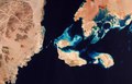
English: The Copernicus Sentinel-2 satellite takes us over Sharm El Sheikh, Egypt. Famous as a resort on the southern tip of the Sinai Peninsula, this coastal strip along the Red Sea is peppered with bars, restaurants and hotels. The ancient Greeks and Romans are thought to have taken their holidays in Egypt as long ago as the 4th century BC.
Click on the box in the lower-right corner to view this image at its full 10 m resolution directly in your browser. This striking true-colour image shows the Gulf of Aqaba at the top centre, feeding into the Red Sea – home to some of the hottest and saltiest seawater in the world. The Red Sea is connected to the Mediterranean Sea via the Suez Canal, one of the world’s busiest waterways. Usually an intense blue-green, as captured in this image, the Red Sea is known, on occasion, to turn reddish-brown owing to algal blooms, which change the colour of the sea when they die off. The area offers many opportunities for diving. In the centre of the image we can see a series of coral reefs, which host rich marine life. The variations in the colour of the water surrounding the islands and in the right of the image represent the depth of water – the lighter areas show more shallow waters than the vast expanse of deep blue, which dominates the image. In the top-right of the image we can see the western tip of mainland Saudi Araba – the beautiful and uninhabited sandy cape of Ras Al-Sheikh Hameed. Here, the red colour represents areas with higher levels of moisture in an arid, desert landscape, whilst the white colour represents salt. Sentinel-2 is a two-satellite mission for land monitoring, providing imagery of soil and water cover, inland waterways and coastal areas, for Europe’s Copernicus environmental monitoring programme. This image, which was captured on 11 April 2017, is also featured on theEarth from Space programme. |
| Date | |
| Source | http://www.esa.int/spaceinimages/Images/2018/07/Sharm_El_Sheikh |
| Author | European Space Agency |
| Permission (Reusing this file) |
contains modified Copernicus Sentinel data (2017), processed by ESA ,CC BY-SA 3.0 IGO |
| Other versions |
|
| Title | Sharm El Sheikh |
| System | Copernicus |
| Set | Earth observation image of the week |
| Mission | Sentinel-2 |
| Activity | Observing the Earth |
Licensing edit
This media was created by the European Space Agency (ESA).
Where expressly so stated, images or videos are covered by the Creative Commons Attribution-ShareAlike 3.0 IGO (CC BY-SA 3.0 IGO) licence, ESA being an Intergovernmental Organisation (IGO), as defined by the CC BY-SA 3.0 IGO licence. The user is allowed under the terms and conditions of the CC BY-SA 3.0 IGO license to Reproduce, Distribute and Publicly Perform the ESA images and videos released under CC BY-SA 3.0 IGO licence and the Adaptations thereof, without further explicit permission being necessary, for as long as the user complies with the conditions and restrictions set forth in the CC BY-SA 3.0 IGO licence, these including that:
See the ESA Creative Commons copyright notice for complete information, and this article for additional details.
|
 | |
This file is licensed under the Creative Commons Attribution-ShareAlike 3.0 IGO license. Attribution: 2017, CC BY-SA IGO 3.0
| ||

|
This image contains data from a satellite in the Copernicus Programme, such as Sentinel-1, Sentinel-2 or Sentinel-3. Attribution is required when using this image.
Attribution: Contains modified Copernicus Sentinel data {{{year}}}
The use of Copernicus Sentinel Data is regulated under EU law (Commission Delegated Regulation (EU) No 1159/2013 and Regulation (EU) No 377/2014). Relevant excerpts:
Free access shall be given to GMES dedicated data [...] made available through GMES dissemination platforms [...].
Access to GMES dedicated data [...] shall be given for the purpose of the following use in so far as it is lawful:
GMES dedicated data [...] may be used worldwide without limitations in time.
GMES dedicated data and GMES service information are provided to users without any express or implied warranty, including as regards quality and suitability for any purpose. |
File history
Click on a date/time to view the file as it appeared at that time.
| Date/Time | Thumbnail | Dimensions | User | Comment | |
|---|---|---|---|---|---|
| current | 02:28, 8 February 2021 | | 5,572 × 3,604 (24.6 MB) | StellarHalo (talk | contribs) | higher resolution |
| 09:04, 13 September 2018 |  | 4,179 × 2,703 (1.22 MB) | Fæ (talk | contribs) | European Space Agency, Id 396541, http://www.esa.int/spaceinimages/Images/2018/07/Sharm_El_Sheikh, User:Fæ/Project_list/ESA |
You cannot overwrite this file.
File usage on Commons
The following 3 pages use this file:
.jpg&redirect=no)