File:Sketch of portions of seacoast of South Carolina & Georgia LOC 99448807.tif

Size of this JPG preview of this TIF file: 800 × 370 pixels. Other resolutions: 320 × 148 pixels | 640 × 296 pixels | 1,024 × 474 pixels | 1,280 × 592 pixels | 2,560 × 1,184 pixels | 11,586 × 5,359 pixels.
Original file (11,586 × 5,359 pixels, file size: 177.64 MB, MIME type: image/tiff)
Captions
Captions
Add a one-line explanation of what this file represents
Summary
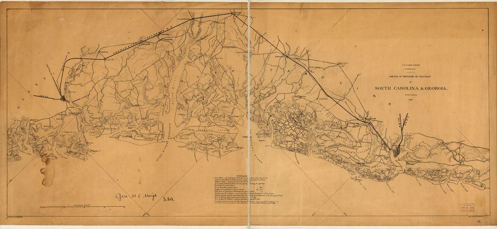
edit| Description |
English: Scale 1:200,000. LC Civil War Maps (2nd ed.), 360 Autographed in ink: Gen. M. C. Meigs USA. Map of the coast from Bull's Bay, South Carolina, to Ossabaw Sound, Georgia, showing forts, drainage, roads, railroads, and towns. "References" at the bottom center of the map give dates on which forts were captured by the Federal forces. Description derived from published bibliography. Available also through the Library of Congress web site as raster image. |
||
| Title | Sketch of portions of seacoast of South Carolina & Georgia | ||
| Shelf ID | G3912.C6 1862 .L5 | ||
| Date | |||
| Source | https://www.loc.gov/item/99448807/ | ||
| Author | Lindenkohl, A. | ||
| Permission (Reusing this file) |
|
||
| Other versions |
|
||
| Location | South Carolina · United States · Georgia | ||
| Part of | Military Battles And Campaigns · American Memory · Civil War Maps · Catalog · Geography And Map Division | ||
| Subject | South Carolina · Maps · Coasts · Georgia · United States |


Licensing
edit|
This is a faithful photographic reproduction of a two-dimensional, public domain work of art. The work of art itself is in the public domain for the following reason:
The official position taken by the Wikimedia Foundation is that "faithful reproductions of two-dimensional public domain works of art are public domain".
This photographic reproduction is therefore also considered to be in the public domain in the United States. In other jurisdictions, re-use of this content may be restricted; see Reuse of PD-Art photographs for details. | ||||
File history
Click on a date/time to view the file as it appeared at that time.
| Date/Time | Thumbnail | Dimensions | User | Comment | |
|---|---|---|---|---|---|
| current | 21:42, 5 June 2018 |  | 11,586 × 5,359 (177.64 MB) | Fæ (talk | contribs) | LOC Maps https://www.loc.gov/item/99448807/ #21212 |
You cannot overwrite this file.
File usage on Commons
The following page uses this file: