File:Sketch of the entrenched lines in the immediate front of Petersburg. (1864-5) LOC 99448480.tif

Size of this JPG preview of this TIF file: 699 × 600 pixels. Other resolutions: 280 × 240 pixels | 560 × 480 pixels | 895 × 768 pixels | 1,194 × 1,024 pixels | 2,387 × 2,048 pixels | 3,301 × 2,832 pixels.
Original file (3,301 × 2,832 pixels, file size: 26.75 MB, MIME type: image/tiff)
Captions
Captions
Add a one-line explanation of what this file represents
Summary edit
| Description |
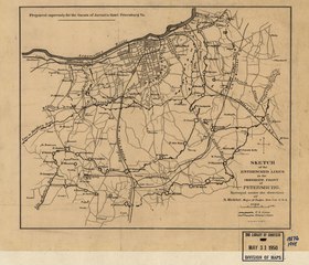
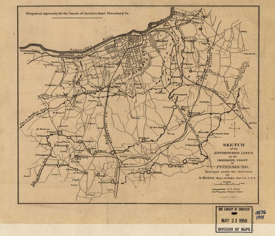
English: Scale ca. 1:63,360. LC Civil War Maps (2nd ed.), 609 Indicates Union and Confederate lines, names of forts, roads, railroads, street pattern of Petersburg, houses, names of residents, and drainage. Description derived from published bibliography. Available also through the Library of Congress web site as raster image. |
||
| Title | Sketch of the entrenched lines in the immediate front of Petersburg. [1864-5] | ||
| Shelf ID | G3884.P4S5 1865 .M5 | ||
| Date | |||
| Source | https://www.loc.gov/item/99448480/ | ||
| Author | Michler, N. (Nathaniel); Michler, N. | ||
| Permission (Reusing this file) |
|
||
| Other versions |
|
||
| Location | United States · Petersburg · Virginia | ||
| Part of | Military Battles And Campaigns · American Memory · Civil War Maps · Catalog · Geography And Map Division | ||
| Subject | Fortification · Virginia · Civil War · United States · Maps · Petersburg (Va.) · Petersburg · History |

_LOC_99448480.jpg)
Licensing edit
|
This is a faithful photographic reproduction of a two-dimensional, public domain work of art. The work of art itself is in the public domain for the following reason:
The official position taken by the Wikimedia Foundation is that "faithful reproductions of two-dimensional public domain works of art are public domain".
This photographic reproduction is therefore also considered to be in the public domain in the United States. In other jurisdictions, re-use of this content may be restricted; see Reuse of PD-Art photographs for details. | ||||
File history
Click on a date/time to view the file as it appeared at that time.
| Date/Time | Thumbnail | Dimensions | User | Comment | |
|---|---|---|---|---|---|
| current | 01:58, 25 June 2018 |  | 3,301 × 2,832 (26.75 MB) | Fæ (talk | contribs) | LOC Maps https://www.loc.gov/item/99448480/ #27294 |
You cannot overwrite this file.
File usage on Commons
The following page uses this file: