File:Slice of Europe ESA356564.tiff
Original file (4,681 × 5,456 pixels, file size: 73.1 MB, MIME type: image/tiff)
Captions
Captions
Summary edit
| Description |
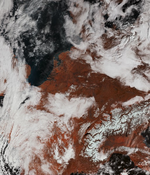
English: Part of Europe from the Alps in the lower right to the North Sea in the upper left was captured by Sentinel-3A’s Ocean and Land Colour Instrument on 10 March 2016. The image utilises only three of the instrument’s 21 spectral channels – giving a false colour impression with land in red. |
| Date | |
| Source | http://www.esa.int/spaceinimages/Images/2016/03/Slice_of_Europe |
| Author | European Space Agency |
| Permission (Reusing this file) |
Contains modified Copernicus Sentinel data [2016], processed by ESA,CC BY-SA 3.0 IGO |
| Other versions |
|
| Title | Slice of Europe |
| Location | Alps |
| Mission | Sentinel-3 |
| Activity | Observing the Earth |

Licensing edit
- You are free:
- to share – to copy, distribute and transmit the work
- to remix – to adapt the work
- Under the following conditions:
- attribution – You must give appropriate credit, provide a link to the license, and indicate if changes were made. You may do so in any reasonable manner, but not in any way that suggests the licensor endorses you or your use.
- share alike – If you remix, transform, or build upon the material, you must distribute your contributions under the same or compatible license as the original.

|
This image contains data from a satellite in the Copernicus Programme, such as Sentinel-1, Sentinel-2 or Sentinel-3. Attribution is required when using this image.
Attribution: Contains modified Copernicus Sentinel data {{{year}}}
The use of Copernicus Sentinel Data is regulated under EU law (Commission Delegated Regulation (EU) No 1159/2013 and Regulation (EU) No 377/2014). Relevant excerpts:
Free access shall be given to GMES dedicated data [...] made available through GMES dissemination platforms [...].
Access to GMES dedicated data [...] shall be given for the purpose of the following use in so far as it is lawful:
GMES dedicated data [...] may be used worldwide without limitations in time.
GMES dedicated data and GMES service information are provided to users without any express or implied warranty, including as regards quality and suitability for any purpose. |
File history
Click on a date/time to view the file as it appeared at that time.
| Date/Time | Thumbnail | Dimensions | User | Comment | |
|---|---|---|---|---|---|
| current | 16:53, 7 May 2017 |  | 4,681 × 5,456 (73.1 MB) | Fæ (talk | contribs) | == {{int:filedesc}} == {{information | description = {{en|1=Part of Europe from the Alps in the lower right to the North Sea in the upper left was captured by Sentinel-3A’s Ocean and Land Colour Instrument on 10 March 2016. The image utilises only th... |
You cannot overwrite this file.
File usage on Commons
The following page uses this file: