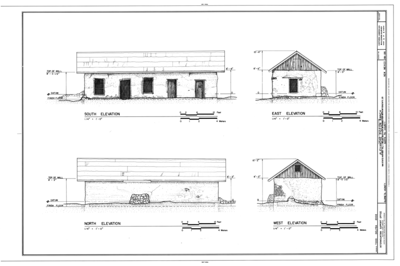
File:South, East, North, and West Elevations - Alexandre Pigeon Ranch, New Mexico State Highway 50, 1.1 miles south of intersection with Interstate 25, Glorieta, Santa Fe County, HABS NM-198 (sheet 3 of 4).png

Original file (14,425 × 9,600 pixels, file size: 4.37 MB, MIME type: image/png)
Captions
Captions
| This image is a JPEG version of the original TIF image at File: South, East, North, and West Elevations - Alexandre Pigeon Ranch, New Mexico State Highway 50, 1.1 miles south of intersection with Interstate 25, Glorieta, Santa Fe County, HABS NM-198 (sheet 3 of 4).tif.
However, any edits to the image should be based on the original TIF version in order to prevent generation loss, and both versions should be updated. Do not make edits based on this version. |
Summary edit
| Warning | The original file is very high-resolution. It might not load properly or could cause your browser to freeze when opened at full size. |
|---|
| South, East, North, and West Elevations - Alexandre Pigeon Ranch, New Mexico State Highway 50, 1.1 miles south of intersection with Interstate 25, Glorieta, Santa Fe County, NM | |||||
|---|---|---|---|---|---|
| Photographer |
Delyea, Todd, creator |
||||
| Title |
South, East, North, and West Elevations - Alexandre Pigeon Ranch, New Mexico State Highway 50, 1.1 miles south of intersection with Interstate 25, Glorieta, Santa Fe County, NM |
||||
| Depicted place | New Mexico; Santa Fe County; Glorieta | ||||
| Date | 2002 | ||||
| Dimensions | 24 x 36 in. (D size) | ||||
| Current location |
Library of Congress Prints and Photographs Division Washington, D.C. 20540 USA http://hdl.loc.gov/loc.pnp/pp.print |
||||
| Accession number |
HABS NM-198 (sheet 3 of 4) |
||||
| Credit line |
|
||||
| Notes |
|
||||
| References |
Related names:
|
||||
| Source | https://www.loc.gov/pictures/item/nm0228.sheet.00003a | ||||
| Permission (Reusing this file) |
|
||||
| Object location | 35° 34′ 59.02″ N, 105° 46′ 09.98″ W | View this and other nearby images on: OpenStreetMap |
|---|
File history
Click on a date/time to view the file as it appeared at that time.
| Date/Time | Thumbnail | Dimensions | User | Comment | |
|---|---|---|---|---|---|
| current | 12:35, 1 August 2014 |  | 14,425 × 9,600 (4.37 MB) | Fæ (talk | contribs) | {{Compressed version|file=File:South,_East,_North,_and_West_Elevations_-_Alexandre_Pigeon_Ranch,_New_Mexico_State_Highway_50,_1.1_miles_south_of_intersection_with_Interstate_25,_Glorieta,_Santa_Fe_County,_HABS_NM-198_(sheet_3_of_4).tif|thumb=nothumb}}... |
You cannot overwrite this file.
File usage on Commons
The following 4 pages use this file:
- File:Cover Sheet and Map - Alexandre Pigeon Ranch, New Mexico State Highway 50, 1.1 miles south of intersection with Interstate 25, Glorieta, Santa Fe County, NM HABS NM-198 (sheet 1 of 4).png
- File:Cover Sheet and Map - Alexandre Pigeon Ranch, New Mexico State Highway 50, 1.1 miles south of intersection with Interstate 25, Glorieta, Santa Fe County, NM HABS NM-198 (sheet 1 of 4).tif
- File:Plan and Sections - Alexandre Pigeon Ranch, New Mexico State Highway 50, 1.1 miles south of intersection with Interstate 25, Glorieta, Santa Fe County, NM HABS NM-198 (sheet 4 of 4).tif
- File:South, East, North, and West Elevations - Alexandre Pigeon Ranch, New Mexico State Highway 50, 1.1 miles south of intersection with Interstate 25, Glorieta, Santa Fe County, HABS NM-198 (sheet 3 of 4).png
Metadata
This file contains additional information such as Exif metadata which may have been added by the digital camera, scanner, or software program used to create or digitize it. If the file has been modified from its original state, some details such as the timestamp may not fully reflect those of the original file. The timestamp is only as accurate as the clock in the camera, and it may be completely wrong.
| Horizontal resolution | 28.35 dpc |
|---|---|
| Vertical resolution | 28.35 dpc |

