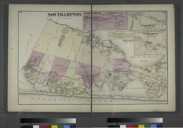
File:Southampton. - Good Ground Canoe Place, Town of Southampton, Suffolk Co. - Union Place, Town of Southampton, Suffolk Co. - West Hampton, Town of Southampton, Suffolk Co. - Speonk, Town of NYPL1527355.tiff

Size of this JPG preview of this TIF file: 800 × 558 pixels. Other resolutions: 320 × 223 pixels | 640 × 447 pixels | 1,024 × 715 pixels | 1,280 × 893 pixels | 2,560 × 1,787 pixels | 10,230 × 7,140 pixels.
Original file (10,230 × 7,140 pixels, file size: 209.01 MB, MIME type: image/tiff)
Captions
Captions
Add a one-line explanation of what this file represents
Summary edit
| Description | Southampton. - Good Ground Canoe Place, Town of Southampton, Suffolk Co. - Union Place, Town of Southampton, Suffolk Co. - West Hampton, Town of Southampton, Suffolk Co. - Speonk, Town of Southampton, Suffolk Co.; Atlases of New York city. / Atlas of Long Island, New York. From recent and actual surveys and records. | |||||||||||||||||||||||
| Notes | Good Ground Canoe Place, Town of Southampton, Suffolk Co. - Union Place, Town of Southampton, Suffolk Co. - West Hampton, Town of Southampton, Suffolk Co. - Speonk, Town of Southampton, Suffolk Co. | |||||||||||||||||||||||
| Catalogue call number | Map Div.++ (Long Island) (Beers, F. W. Atlas of Long Island, New York) | |||||||||||||||||||||||
| Item/Page/Plate | 186-187 | |||||||||||||||||||||||
| Date | ||||||||||||||||||||||||
| Source |
http://digitalgallery.nypl.org/nypldigital/dgkeysearchdetail.cfm?imageID=1527355
|
|||||||||||||||||||||||
| Author | F. W. (Frederick W.) - Cartographer Beers | |||||||||||||||||||||||
| Permission (Reusing this file) |
From The Lionel Pincus and Princess Firyal Map Division. http://maps.nypl.org
|
|||||||||||||||||||||||
| Other versions | File:1873 Beers Map of Southampton, Bridgeampton and Sag Harbor, Long Island, New York - Geographicus - Southampton-beers-1873.jpg | |||||||||||||||||||||||
| Source description | 192 p. incl. maps. 40 cm. | |||||||||||||||||||||||
| Location | Stephen A. Schwarzman Building / The Lionel Pincus and Princess Firyal Map Division | |||||||||||||||||||||||
| Digital item published | 7-28-2006; updated 3-25-2011 | |||||||||||||||||||||||
| Digital ID | 1527355 | |||||||||||||||||||||||

The making of this file was supported by Wikimedia UK.
To see other files made with the support of Wikimedia UK, please see the category Supported by Wikimedia UK.
|
File history
Click on a date/time to view the file as it appeared at that time.
| Date/Time | Thumbnail | Dimensions | User | Comment | |
|---|---|---|---|---|---|
| current | 17:26, 4 May 2014 |  | 10,230 × 7,140 (209.01 MB) | Fæ (talk | contribs) | GWToolset: Creating mediafile for Fæ. Tranche 3 17512-20314 @ 11:54, 3 March 2014 |
You cannot overwrite this file.
File usage on Commons
There are no pages that use this file.