File:St. Margrethenberg - Furggels (9047031947).jpg

Size of this preview: 800 × 533 pixels. Other resolutions: 320 × 213 pixels | 640 × 426 pixels | 1,024 × 682 pixels | 1,280 × 852 pixels | 2,560 × 1,705 pixels | 4,000 × 2,664 pixels.
Original file (4,000 × 2,664 pixels, file size: 7.06 MB, MIME type: image/jpeg)
Captions
Captions
Add a one-line explanation of what this file represents
Summary edit
.jpg&action=edit§ion=1)
| Description |
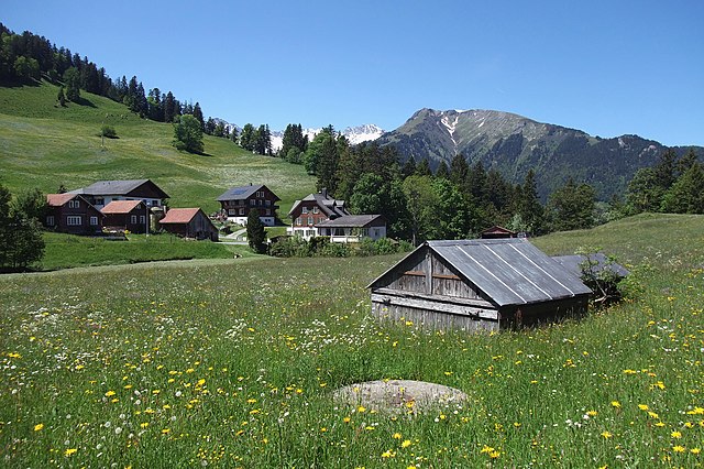
English: Under the hills of St. Margrethenberg, there is an old artillery fortress from the time of WW2 located. The armored turret gun No. 3 of caliber 105 mm in the foreground (camouflaged with a cottage) is only 90 m away from the Restaurant Tristeli. On July 2, 1940 was this gun the first time fired for calibration. Tradition holds that the glasses are plunged from the rack in the restaurant. The cannon is located at a height of 1188 m. ü. M. (3897 ft ASL). The access tunnel in the fort is 32 m below the ground. A staircase with 150 steps leads up to the gun here. These guns were decommissioned in 1994. The metal cap on the round part of concrete in the meadow was one of three exhaust pipes from the engine room. This exhaust pipe had children once clogged with a ball, when the fortress was still active. An anecdote of retired military fortress guard Fidel Nigg. Switzerland, June 13, 2013. |
| Date | |
| Source | https://www.flickr.com/photos/kecko/9047031947/ |
| Author | Kecko |
| Permission (Reusing this file) |
At the time of upload, the image license was automatically confirmed using the Flickr API. For more information see Flickr API detail. |
| Flickr sets |
|
| Flickr pools |
|
| Flickr tags |
|
| Camera location | | View this and other nearby images on: OpenStreetMap |
|---|
.jpg¶ms=046.982084_N_0009.506754_E_globe:Earth_type:camera__&language=en)
Licensing edit
.jpg&action=edit§ion=2)
This file is licensed under the Creative Commons Attribution 2.0 Generic license.
- You are free:
- to share – to copy, distribute and transmit the work
- to remix – to adapt the work
- Under the following conditions:
- attribution – You must give appropriate credit, provide a link to the license, and indicate if changes were made. You may do so in any reasonable manner, but not in any way that suggests the licensor endorses you or your use.
| This image was originally posted to Flickr by Kecko at https://flickr.com/photos/70981241@N00/9047031947. It was reviewed on 13 December 2016 by FlickreviewR and was confirmed to be licensed under the terms of the cc-by-2.0. |
File history
Click on a date/time to view the file as it appeared at that time.
| Date/Time | Thumbnail | Dimensions | User | Comment | |
|---|---|---|---|---|---|
| current | 10:18, 13 December 2016 | | 4,000 × 2,664 (7.06 MB) | Fæ (talk | contribs) | Kecko, Set 72157624975416125, ID 9047031947, Original title St. Margrethenberg - Furggels |
You cannot overwrite this file.
File usage on Commons
There are no pages that use this file.
.jpg&oldid=779621348)