File:Street map of central Washington D.C. showing parklands and all government buildings. LOC 2013589322.tif

Size of this JPG preview of this TIF file: 800 × 566 pixels. Other resolutions: 320 × 226 pixels | 640 × 452 pixels | 1,024 × 724 pixels | 1,280 × 905 pixels | 2,560 × 1,810 pixels | 6,033 × 4,265 pixels.
Original file (6,033 × 4,265 pixels, file size: 73.62 MB, MIME type: image/tiff)
Captions
Captions
Add a one-line explanation of what this file represents
Summary
edit| Description |
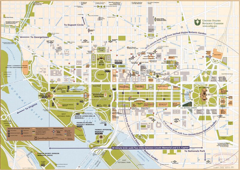
English: Selected buildings shown pictorially. Also shows "National Park Service visitor services" and radial walking times/distances from the "U.S. Botanic Garden". Title devised by cataloguer. Gift: Charles B. Peterson; June 2013. Includes United States Botanic Garden logotype at upper right. Available also through the Library of Congress Web site as a raster image. |
||
| Title | [Street map of central Washington D.C. showing parklands and all government buildings]. | ||
| Shelf ID | G3851.G52 2013 .U5 | ||
| Date | |||
| Source | https://www.loc.gov/item/2013589322/ | ||
| Author | United States Botanic Garden; United States. National Park Service | ||
| Permission (Reusing this file) |
|
||
| Other versions |
|
||
| Location | United States · Washington D.C. · District Of Columbia · Washington | ||
| Part of | American Memory · Cities And Towns · Catalog · Geography And Map Division | ||
| Subject | Washington (D.C.) · Walking · Washington · Tourist Maps · Central Business Districts · Parks · United States · Maps · District Of Columbia · Public Buildings |


Licensing
edit| This image or media file contains material based on a work of a National Park Service employee, created as part of that person's official duties. As a work of the U.S. federal government, such work is in the public domain in the United States. See the NPS website and NPS copyright policy for more information. |
File history
Click on a date/time to view the file as it appeared at that time.
| Date/Time | Thumbnail | Dimensions | User | Comment | |
|---|---|---|---|---|---|
| current | 22:41, 7 June 2018 |  | 6,033 × 4,265 (73.62 MB) | Fæ (talk | contribs) | LOC Maps https://www.loc.gov/item/2013589322/ #23183 |
You cannot overwrite this file.
File usage on Commons
The following 3 pages use this file: