File:Taboas geraes de toda a navegação LOC 78653638-4.tif

Size of this JPG preview of this TIF file: 800 × 477 pixels. Other resolutions: 320 × 191 pixels | 640 × 381 pixels | 1,024 × 610 pixels | 1,280 × 763 pixels | 2,560 × 1,525 pixels | 9,200 × 5,481 pixels.
Original file (9,200 × 5,481 pixels, file size: 144.27 MB, MIME type: image/tiff)
Captions
Captions
Add a one-line explanation of what this file represents
Summary
edit| Description |
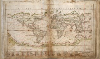
English: Relief shown pictorially. LC Luso-Hispanic World, 8 Orientation varies. Pen-and-ink and watercolor. Preface (4 p.) and last map created and added in 1692 by Don Francisco de Seixas y Lovera. Some staining and acid-transfer throughout. Bound in white paper in 1983. Available also through the Library of Congress Web site as a raster image. |
||
| Title | Taboas geraes de toda a navegação | ||
| Shelf ID | G1015 .T4 1630 | ||
| Parent | https://www.loc.gov/resource/g3200m.gct00052/ | ||
| Sheet title | World | ||
| Date | |||
| Source | https://www.loc.gov/item/78653638/ | ||
| Author | Albernaz, João Teixeira; Attayde, Jeronimo De.; Seixas Y Lovera, Francisco De. | ||
| Permission (Reusing this file) |
|
||
| Other versions |
|
||
| Location | Earth · Portugal | ||
| Part of | American Memory · Catalog · Geography And Map Division · Cultural Landscapes | ||
| Subject | Atlases · World Maps, Manuscript · Portugal · Nautical Charts · Early Works To 1800 · World Atlases · Earth · Atlases, Portuguese · Harbors |


Licensing
edit|
This is a faithful photographic reproduction of a two-dimensional, public domain work of art. The work of art itself is in the public domain for the following reason:
The official position taken by the Wikimedia Foundation is that "faithful reproductions of two-dimensional public domain works of art are public domain".
This photographic reproduction is therefore also considered to be in the public domain in the United States. In other jurisdictions, re-use of this content may be restricted; see Reuse of PD-Art photographs for details. | ||||
File history
Click on a date/time to view the file as it appeared at that time.
| Date/Time | Thumbnail | Dimensions | User | Comment | |
|---|---|---|---|---|---|
| current | 09:10, 22 May 2018 |  | 9,200 × 5,481 (144.27 MB) | Fæ (talk | contribs) | LOC Maps multisheet https://www.loc.gov/item/78653638/ sheet 4 of 31 #9731 |
You cannot overwrite this file.
File usage on Commons
The following page uses this file: