File:Tenochtitlán, 1521 WDL503.png
Size of this preview: 800 × 547 pixels. Other resolutions: 320 × 219 pixels | 640 × 437 pixels | 1,024 × 700 pixels | 1,280 × 875 pixels | 1,498 × 1,024 pixels.
Original file (1,498 × 1,024 pixels, file size: 2.81 MB, MIME type: image/png)
Captions
Captions
Add a one-line explanation of what this file represents
Summary edit
| Title |
Русский: Теночтитлан, 1521 г.
Français : Tenochtitlán, 1521
English: Tenochtitlán, 1521
中文:特诺奇蒂特兰,1521
Português: Tenochtitlán, 1521
العربية: تينوشتيتلان، 1521
Español: Tenochtitlán, 1521 |
| Description |
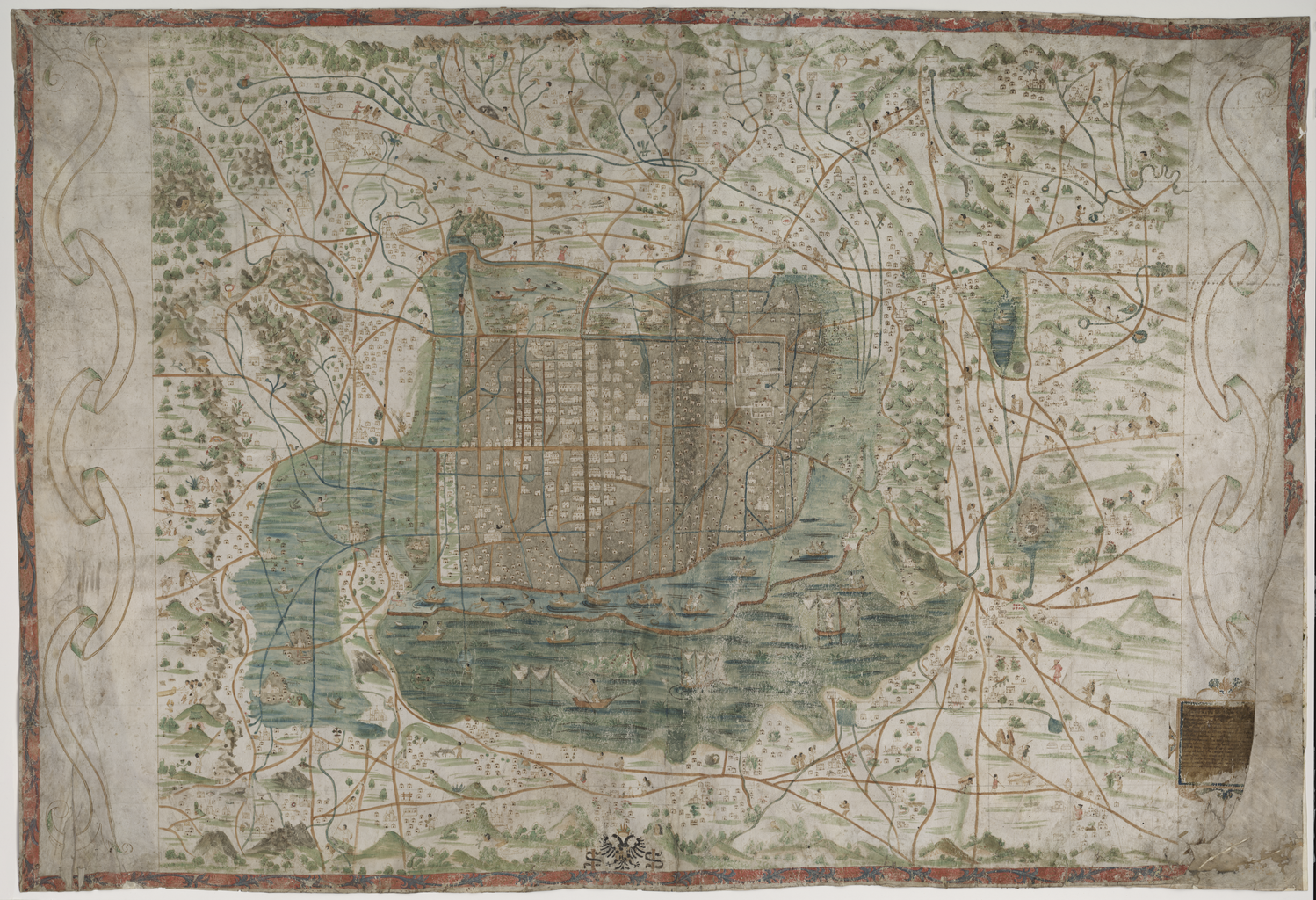
Русский: Эта топографическая карта города Мехико и его окрестностей была составлена примерно в 1550 г., почти через три десятилетия после завоевания Эрнаном Кортесом ацтекской столицы города Теночтитлана в 1521 году. Теночтитлан был основан в XIV веке на острове посреди соленого озера Тескоко. После завоевания города испанцы снесли его центральные части и вместо ацтекских храмов построили здания в испанском стиле, оставив практически без изменения расположение улиц. На карте показаны новые сооружения. В центре карты, рядом с площадью, которая в наши дни называется Plaza de la Constitución, изображен кафедральный собор (Iglesia Mayor). В нижнем правом углу карты можно видеть часть надписи с посвящением императору Карлу V, а также часть имени Санта Крус, именно поэтому живший в Севилье королевский космограф Альфонсо де Санта Крус (1505–1567 гг.) долгое время считался составителем карты. Более поздние исследования указывают, что карта была нарисована человеком, жившим в Теночтитлане/Мехико, возможно, ацтеком, получившим европейское образование. Известно, что Санта Крус никогда не посещал Мехико, а строение карты и ее информационное содержание позволяют предположить, что составитель был хорошо знаком с городом и его жителями. Символы на карте (изображения голов, зверей, колец, звезд и пр.) представляют собой географические названия на науатле, языке ацтеков. Карта содержит информацию об общественной и трудовой деятельности, о животных и растениях, предоставляя кроме географического описания богатую картину повседневной жизни города Мехико в XVI веке. Карта помещена в рамку из декоративного лиственного орнамента, изображенного синим цветом на красном фоне. Дороги и каналы отмечены коричневым и голубым цветом. Неизвестно, как карта попала в Швецию. По одной теории, шведский лингвист и путешественник Юхан Габриэль Спарвенфельд приобрел ее во время своего пребывания в Испании в конце XVII века, а позднее карта была передана в дар Библиотеке Уппсальского университета.
Животные; Искусство, мексиканское; Искусство ацтеков; Нравы и обычаи; Рукописные карты; Иллюстрированные карты; Растения; Испания–Колонии; Топографические карты Français : Cette carte topographique de la ville de Mexico et de ses environs date de 1550 environ, quelque trois décennies après la conquête de la capitale aztèque Tenochtitlán par Hernán Cortés en 1521. Tenochtitlán fut fondée au XIVe siècle sur une île dans le lac salé de Texcoco. Lorsqu'ils occupèrent la ville, les espagnols démolirent sa partie centrale et remplacèrent les temples aztèques par des bâtiments construits dans le style espagnol, mais ils laissèrent la disposition des rues presque intacte. La carte montre les nouveaux bâtiments. La cathédrale (Iglesia Major) figure au centre de la carte, à côté de la place qui est devenue aujourd'hui la Plaza de la Constitución. On peut apercevoir une partie de la dédicace à l'empereur Charles Quint dans le coin inférieur droit, ainsi que des parties du nom Santa Cruz, c'est pourquoi on a longtemps pensé que c'était le cosmographe royal de Séville, Alfonso de Santa Cruz (1505–1567), qui avait été le cartographe. Des recherches ultérieures indiquent que la carte a été peinte par une personne provenant de Tenochtitlán (ville de Mexico), probablement un aztèque ayant reçu une éducation européenne. Il est admis que Santa Cruz ne s'est jamais rendu au Mexique, et la réalisation et le contenu de la carte suggèrent que son auteur connaissait parfaitement l'endroit et ses habitants. Les symboles sur la carte (têtes, animaux, anneaux, étoiles, etc.) représentent des noms de lieux en nahuatl, la langue des aztèques. La carte comporte des informations concernant la vie sociale et professionnelle, les animaux et les plantes, offrant ainsi à la fois des descriptions géographiques et un riche aperçu de la vie quotidienne au XVIe siècle dans la ville de Mexico. Le cadre est formé d'un feuillage ornemental peint en bleu sur fond rouge. Les routes et les canaux sont indiqués en marron et en bleu clair. On ignore comment la carte est arrivée en Suède. Une théorie veut que le linguiste et voyageur suédois Johan Gabriel Sparwenfeld l'ait achetée au cours de son séjour en Espagne à la fin du XVIIe siècle et qu'elle ait été donnée plus tard à la Bibliothèque de l'Université d'Uppsala.
Animaux; Art mexicain; Art aztèque; Mœurs et coutumes; Cartes manuscrites; Cartes picturales; Plantes; Espagne--Colonies; Cartes topographiques English: This topographical map of Mexico City and its surroundings dates from around 1550, some three decades after the conquest of the Aztec capital of Tenochtitlán by Hernán Cortés in 1521. Tenochtitlán was founded in the 14th century on an island in the salt lake of Texcoco. Upon occupying the city, the Spanish pulled down its central parts and replaced the Aztec temples with buildings constructed in the Spanish style, but they left the street layout virtually intact. The map shows the new buildings. The cathedral (Iglesia Major) is in the center of the map, next to the square that today is the Plaza de la Constitución. Part of the dedication to Emperor Charles V can be seen in the lower right-hand corner, along with parts of the name Santa Cruz, which is why the royal cosmographer in Seville, Alfonso de Santa Cruz (1505–67), long was thought to have been the cartographer. Later research indicates that the map was painted by a person from Tenochtitlán/Mexico City, probably an Aztec with European schooling. It is known that Santa Cruz never visited Mexico, and the construction and content of the map suggest that its maker was very familiar with the place and its inhabitants. The symbols on the map (heads, animals, rings, stars, and so forth) represent place-names in Nahuatl, the language of the Aztecs. The map contains information about social and working life and animals and plants, thus providing both a geographical description and a rich picture of everyday life in 16th-century Mexico City. The frame consists of ornamental foliage painted in blue on a red background. Roads and canals are marked in brown and light blue. How the map came to Sweden is not known. One theory is that Swedish linguist and traveler Johan Gabriel Sparwenfeld purchased it during his stay in Spain in the late 17th century and that it later was donated to the Uppsala University Library.
Animals; Art, Mexican; Aztec art; Manners and customs; Manuscript maps; Pictorial maps; Plants; Spain--Colonies; Topographic maps 中文:这幅墨西哥城及其周边环境的地形图大约绘制于 1550 年,也就是赫尔南·科尔特斯 (Hernán Cortés) 1521 年征服阿兹特克首都特诺奇蒂特兰后的三十年。特诺奇蒂特兰于 14 世纪建于特斯科科盐湖的一座岛屿上。西班牙人在征服该城后,拆毁了城市中央的建筑物,夷平了阿兹特克神庙,然后用西班牙风格的建筑取而代之,但是几乎完好无损地保留了街道布局。地图显示的是新建筑。地图中央是大教堂 (Iglesia Major),大教堂旁边是宪法广场,右下角附有献给君主查尔斯五世 (Charles V) 的部分题词。长期以来,这幅地图一直被认为是塞维利亚的皇家宇宙学家阿方索·圣克鲁斯(Alfonso de Santa Cruz,1505–1567 年)所绘制,因为其上标注有他的名字的一部分 — "Santa Cruz"(圣克鲁斯)。后来的研究表明,地图是由来自特诺奇蒂特兰/墨西哥城的一名人士绘制,该人士很可能是受过欧洲教育的阿兹特克人。因为圣克鲁斯从未到访过墨西哥,而从地图上的建筑和内容来看,绘制者对该地区以及这一地区的居民非常熟悉。地图上的符号(头部、动物、圆圈、星星等)是用纳瓦特尔语(阿兹特克人的语言)表示的地点名称。地图中包含有关社会、劳作生活和动植物的信息,因此不仅描述了地理位置,还是 16 世纪墨西哥城日常生活的真实写照。边框采用红色背景,上面点缀着蓝色装饰树叶。道路和河渠用棕色和浅蓝色标记表示。无人知晓这幅地图是如何来到瑞典的。一种说法是瑞典语言学家和旅行家约翰·加布里埃尔·斯巴温弗德 (Johan Gabriel Sparwenfeld) 17 世纪晚期在西班牙逗留期间购买了它,后来把它捐赠给了乌普萨拉大学图书馆。
动物; 墨西哥的艺术; 阿兹特克艺术; 风俗礼仪; 手绘地图; 图示地图; 植物; 西班牙-殖民地; 地形图 Português: Este mapa topográfico da Cidade do México e de seus arredores está datado por volta de 1550, cerca de três décadas após a conquista da capital asteca de Tenochtitlán por Hernán Cortés, em 1521. Tenochtitlán foi fundada no século XIV em uma ilha, no lago salgado de Texcoco. Ao ocupar a cidade, os espanhóis derrubaram suas partes centrais e substituiram os templos astecas por edifícios construídos em estilo espanhol, mas deixaram o arruamento praticamente intacto. O mapa mostra os novos edifícios. A catedral (Iglesia Major) encontra-se no centro do mapa, junto à praça onde é hoje a Plaza de la Constitución. Parte da dedicação ao Imperador Carlos V pode ser lida no canto inferior direito, juntamente com partes do nome Santa Cruz, que é a razão pela qual se pensava que o cosmógrafo real de Sevilha, Alfonso de Santa Cruz (1505-1567) tivesse sido o cartógrafo. Pesquisas posteriores indicam que o mapa foi pintado por uma pessoa de Tenochtitlán, ou Cidade do México, provavelmente um asteca com escolaridade europeia. Sabe-se que Santa Cruz nunca visitou o México, e a construção e o conteúdo do mapa sugerem que seu criador estava muito familiarizado com o local e com os seus habitantes. Os símbolos no mapa (cabeças, animais, anéis, estrelas, etc.) representam nomes de lugares em náuatle, a língua dos astecas. O mapa contém informações sobre a vida social e profissional, e sobre animais e plantas, proporcionando tanto uma descrição geográfica quanto um retrato rico da vida cotidiana na Cidade do México do século XVI. A moldura consiste de folhagens ornamentais pintadas em azul sobre um fundo vermelho. As estradas e os canais estão marcados em marrom e azul claro. Como o mapa chegou até a Suécia não se tem conhecimento. Uma teoria é que o linguista e viajante sueco Johan Gabriel Sparwenfeld comprou-o durante sua estada na Espanha, no final do século XVII, e que mais tarde foi doado à Biblioteca da Universidade de Uppsala.
Animais; Arte, Mexicana; Arte asteca; Usos e costumes; Mapas manuscritos; Mapas pictóricos; Plantas; Espanha - Colônias; Mapas topográficos العربية: يعود تاريخ هذه الخريطة الطبوغرافية لمكسيكو سيتي وضواحيها لعام 1550 تقريبا، أي بعد حوالي ثلاثة عقود من غزو هرنان كورتيز لمدينة تينوشتيتلان عاصمة الأزتيك عام 1521. وأنشئت مدينة تينوشتيتلان في القرن الرابع عشر على جزيرة في بحيرة تيكسكوكو المالحة. وبمجرد احتلالهم للمدينة، قام الأسبان بهدم الأجزاء الوسطى واستبدلوا معابد الأزتيك بمباني تم إنشائها على الطراز الأسباني، ولكنهم تركوا تخطيط الشوارع كما هو. وتُظْهِر الخريطة المباني الجديدة. كما تَظْهَر الكاتدرائية (إغليزيا ميجور) في وسط الخريطة، بجوار الميدان المعروف حاليا ببلازا دي لا كونستوتيسيون. ويمكن رؤية جزء من الإهداء الموجه للإمبراطور تشارلز الخامس في الركن السفلي الأيمن، بالإضافة إلى جزء من اسم سانتا كروز، ولذلك ساد اعتقاد لفترة طويلة مفاده أن الكوزموغرافي الملكي في اشبيلية، ألفونسو دي سانتا كروز (1505-1567)، هو الذي قام برسم الخريطة. وقد أشارت الأبحاث فيما بعد إلى أن شخصا من تينوشتيتلان/مكسيكو سيتي هو الذي قام برسم الخريطة، وربما يكون هذا الشخص من الأزتيك ودرس في أوروبا. فمن المعروف أن سانتا كروز لم يقم مطلقا بزيارة المكسيك، بالإضافة إلى أن تكوين ومحتوى الخريطة يشير إلى أن من قام برسمها كان يعرف المكان وقاطِنيه بشكل جيّدٍ جداً. وتَظْهَر الرموز (الرؤوس، الحيوانات، الحلقات، النجوم، وغيرها) الظاهرة على الخريطة، والتي توضح أسماء الأماكن، مكتوبةً بالناهواتل، لغة الأزتيك. وتتضمن الخريطة معلومات عن الحياة الاجتماعية والعملية والحيوانات والنباتات، مما يعد وصفا جغرافيا وتصويرا دقيقا للحياة اليومية في مكسيكو سيتي في القرن السادس عشر. ويتألف الإطار من زخارف نباتية مرسومة باللون الأزرق على خلفية حمراء. وتم تمييز الطرق والقنوات باللونين البني والأزرق الفاتح. ولا يُعرف كيف وصلت الخريطة إلى السويد. وتشير إحدى النظريات إلى أن لغويا ورحالةً سويديا يدعى يوهان جابرييل سبارونفيلد قام بشرائها أثناء إقامته في أسبانيا في أواخر القرن السابع عشر وتم إهداؤها بعد ذلك إلى مكتبة جامعة أوبسالا.
الحيوانات; فن، مكسيكي; الفن الأزتيكي; السلوكيات والعادات; الخرائط المخطوطة; خرائط مصورة; النباتات; إسبانيا -- المستعمرات; الخرائط الطبوغرافية Español: Este mapa topográfico de la ciudad de México y sus alrededores data de alrededor de 1550, más o menos tres décadas después de que Hernán Cortés conquistara la capital azteca de Tenochtitlán en 1521. Esta ciudad se fundó en el siglo XIV en una isla en el lago salado de Texcoco. Al ocupar la ciudad, los españoles derribaron las partes centrales y reemplazaron los templos aztecas por edificios construidos con estilo español, pero dejaron el trazado de las calles prácticamente intacto. El mapa muestra los edificios nuevos. La catedral (Iglesia Mayor) está en el centro del mapa, junto a la plaza que hoy es la Plaza de la Constitución. En la esquina inferior derecha se puede ver parte de una dedicatoria al emperador Carlos V, junto con partes del nombre Santa Cruz; debido a esto, se creyó por mucho tiempo que Alfonso de Santa Cruz (1505–1567), el cosmógrafo real de Sevilla, había sido el cartógrafo. La investigación posterior indica que el pintor fue una persona de Tenochtitlán, o la ciudad de México, probablemente un azteca con educación europea. Se sabe que Santa Cruz nunca visitó México, y la construcción y el contenido del mapa sugieren que su autor estaba muy familiarizado con la ciudad y sus habitantes. Los símbolos en el mapa (cabezas, animales, anillos, estrellas, etcétera) representan topónimos en náhuatl, el idioma de los aztecas. El mapa contiene información acerca de la vida social y laboral y sobre la flora y la fauna; de esta manera, proporciona tanto una descripción geográfica como un rico panorama de la vida cotidiana en la ciudad de México del siglo XVI. El marco es un follaje ornamental pintado en azul sobre fondo rojo. Las carreteras y los canales están marcados en marrón y celeste. No se sabe cómo llegó el mapa a Suecia. Una de las teorías es que el lingüista y viajero sueco Johan Gabriel Sparwenfeld lo compró durante su estadía en España a finales del siglo XVII, y que luego se donó a la Biblioteca de la Universidad de Uppsala.
Animales; Arte mexicano; Arte azteca; Usos y costumbres; Mapas manuscritos; Mapas pictóricos; Plantas; España - Colonias; Mapas topográficos |
| Date | 1550 |
| Medium |
Русский: Карты
Français : Cartes
English: Maps
中文:地图
Português: Mapas
العربية: خرائط
Español: Mapas |
| Dimensions |
English: 1 map, 75 x 144 centimeters, hand-painting on two joined pieces of parchment |
| Collection |
Русский: Библиотека Уппсальского университета
Français : Bibliothèque de l'Université d'Uppsala
English: Uppsala University Library
中文:乌普萨拉大学图书馆
Português: Biblioteca da Universidade de Uppsala
العربية: مكتبة جامعة أوبسالا
Español: Biblioteca de la Universidad de Uppsala |
| Place of creation |
Русский: Мехико
Français : Mexico
English: Mexico City
中文:墨西哥城
Português: Cidade do México
العربية: مكسيكو سيتي
Español: Ciudad de México |
| References | http://hdl.loc.gov/loc.wdl/swuu.503 |
| Source/Photographer |
|
Licensing edit
|
This is a faithful photographic reproduction of a two-dimensional, public domain work of art. The work of art itself is in the public domain for the following reason:
The official position taken by the Wikimedia Foundation is that "faithful reproductions of two-dimensional public domain works of art are public domain".
This photographic reproduction is therefore also considered to be in the public domain in the United States. In other jurisdictions, re-use of this content may be restricted; see Reuse of PD-Art photographs for details. | ||||
File history
Click on a date/time to view the file as it appeared at that time.
| Date/Time | Thumbnail | Dimensions | User | Comment | |
|---|---|---|---|---|---|
| current | 18:58, 11 March 2014 | | 1,498 × 1,024 (2.81 MB) | Fæ (talk | contribs) | =={{int:filedesc}}== {{Artwork |artist = |author = |title ={{ru|1=Теночтитлан, 1521 г.}} {{fr|1=Tenochtitlán, 1521}} {{en|1=Tenochtitlán, 1521}} {{zh|1=特诺奇蒂特兰,1521}} {{pt|1=Tenochtitlán, 1521}} {{ar|1=تينوشتيتلا... |
You cannot overwrite this file.
File usage on Commons
The following page uses this file:
File usage on other wikis
The following other wikis use this file:
- Usage on en.wikipedia.org
- Usage on fr.wikipedia.org