File:Territory and military department of New Mexico LOC 2015591072.tif

Size of this JPG preview of this TIF file: 800 × 573 pixels. Other resolutions: 320 × 229 pixels | 640 × 458 pixels | 1,024 × 733 pixels | 1,280 × 917 pixels | 2,560 × 1,834 pixels | 10,441 × 7,478 pixels.
Original file (10,441 × 7,478 pixels, file size: 223.38 MB, MIME type: image/tiff)
Captions
Captions
Add a one-line explanation of what this file represents
Summary
edit| Description |
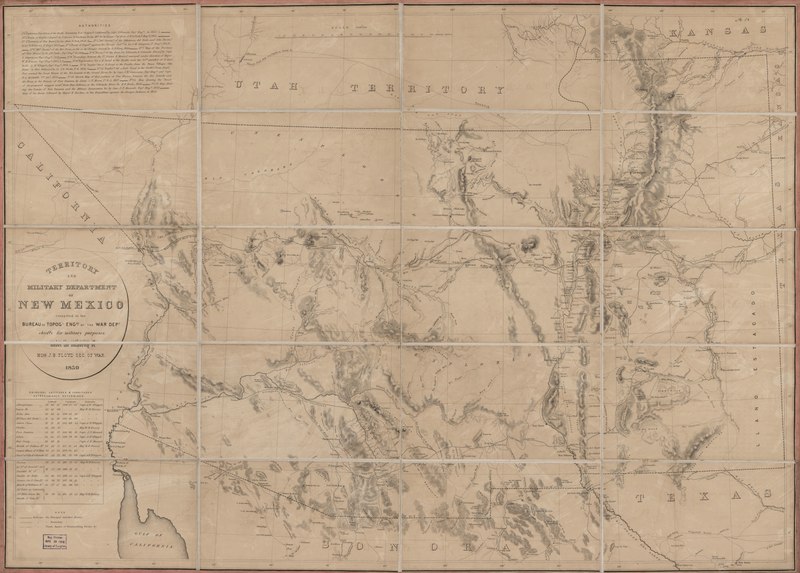
English: Covers territory between Utah and Mexico, from the Colorado River to the Liano Estacado; shows trails and wagon roads, forts, expeditions and explorations of the Southwest; names places and known rivers and mountain ranges. |
||
| Title | Territory and military department of New Mexico | ||
| Shelf ID | G4300 1859 .U5 | ||
| Date | |||
| Source | https://www.loc.gov/item/2015591072/ | ||
| Author | United States. Army. Corps Of Topographical Engineers; Dougal, William H. | ||
| Permission (Reusing this file) |
|
||
| Other versions |
|
||
| Location | Arizona · Southwest, New · Arizona. · United States · New Mexico · New Mexico. · Southwest, New. | ||
| Part of | American Memory · Catalog · Geography And Map Division · Discovery And Exploration | ||
| Subject | Arizona · Southwest, New · Military Maps · United States · Maps · New Mexico |


Licensing
edit| This work is from the Library of Congress. According to the library, there are no known copyright restrictions on the use of this work. |  |
File history
Click on a date/time to view the file as it appeared at that time.
| Date/Time | Thumbnail | Dimensions | User | Comment | |
|---|---|---|---|---|---|
| current | 20:18, 20 May 2018 |  | 10,441 × 7,478 (223.38 MB) | Fæ (talk | contribs) | LOC Maps https://www.loc.gov/item/2015591072/ #378 |
You cannot overwrite this file.
File usage on Commons
The following page uses this file: