File:The American Civil War-maps. LOC 2009581126-39.tif

Size of this JPG preview of this TIF file: 498 × 600 pixels. Other resolutions: 199 × 240 pixels | 398 × 480 pixels | 637 × 768 pixels | 850 × 1,024 pixels | 1,700 × 2,048 pixels | 2,615 × 3,150 pixels.
Original file (2,615 × 3,150 pixels, file size: 23.57 MB, MIME type: image/tiff)
Captions
Captions
Add a one-line explanation of what this file represents
Summary edit
| Description |
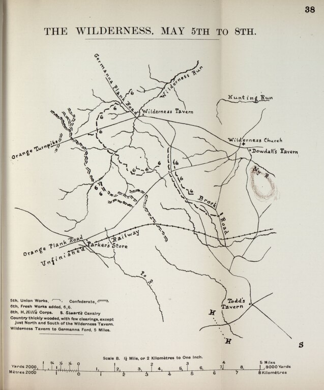
Map of the Battle of the Wilderness English: Title from cover. Issued to accompany Formby, John. The American Civil War, a concise history of its causes, progress, and results (London, John Murray, 1910). Listed in C.E. Le Gear's A List of Geographical Atlases in the Library of Congress (Washington, Library of Congress, 1973), v. 7, no. 10657. LC Civil War Maps (2nd ed.), 65 Available also through the Library of Congress Web site as a raster image. Includes maps of the principal campaigns and battles of the Civil War. Description derived from published bibliography. Errata slip inserted. LC copy imperfect: Spine detached and some map sheets torn apart from spine. |
||
| Title | The American Civil War--maps. | ||
| Shelf ID | G1201.S5 F6 1910b | ||
| Parent | https://www.loc.gov/resource/g3701sm.gcw0065000/ | ||
| Sheet title | The Wilderness, May 5-8 | ||
| Date | |||
| Source | https://www.loc.gov/item/2009581126/ | ||
| Author | Formby, John | ||
| Permission (Reusing this file) |
|
||
| Other versions |
|
||
| Location | United States | ||
| Part of | Military Battles And Campaigns · American Memory · Civil War Maps · Catalog · Geography And Map Division | ||
| Subject | United States · Maps · Campaigns · Civil War · History |


Licensing edit
|
This is a faithful photographic reproduction of a two-dimensional, public domain work of art. The work of art itself is in the public domain for the following reason:
The official position taken by the Wikimedia Foundation is that "faithful reproductions of two-dimensional public domain works of art are public domain".
This photographic reproduction is therefore also considered to be in the public domain in the United States. In other jurisdictions, re-use of this content may be restricted; see Reuse of PD-Art photographs for details. | ||||
File history
Click on a date/time to view the file as it appeared at that time.
| Date/Time | Thumbnail | Dimensions | User | Comment | |
|---|---|---|---|---|---|
| current | 01:12, 3 July 2018 |  | 2,615 × 3,150 (23.57 MB) | Fæ (talk | contribs) | LOC Maps multisheet https://www.loc.gov/item/2009581126/ sheet 39 of 64 #20100 |
You cannot overwrite this file.
File usage on Commons
The following page uses this file: