File:The Glenwood Herald's map of Pope County, Minn. LOC 2012593035.jpg

Size of this preview: 700 × 599 pixels. Other resolutions: 280 × 240 pixels | 561 × 480 pixels | 897 × 768 pixels | 1,196 × 1,024 pixels | 2,392 × 2,048 pixels | 6,411 × 5,490 pixels.
Original file (6,411 × 5,490 pixels, file size: 6.51 MB, MIME type: image/jpeg)
Captions
Captions
Add a one-line explanation of what this file represents
Summary
edit| Description |
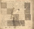
English: Cadastral map showing drainage, roads, school houses, churches, land ownership, landowners' names, etc. Photostat copy. "Copyright ... by Kroshus & Brendal." "Hunter & VanValkenburgh, Map Publishers, Rockford, Ill." LC copy imperfect: Stained at edges and taped on verso; map information partly illegible. Includes text, 1900 census figures, hand-written note "Property of U.S.G.S," and advertisements. Available also through the Library of Congress Web site as a raster image. |
||
| Title | The Glenwood Herald's map of Pope County, Minn. | ||
| Shelf ID | G4143.P7 1904 .K71 | ||
| Date | |||
| Source | https://www.loc.gov/item/2012593035/ | ||
| Author | Kroshus & Brendal | ||
| Permission (Reusing this file) |
|
||
| Other versions |
|
||
| Location | United States · Pope County · Minnesota | ||
| Part of | American Memory · Catalog · County Landownership Maps · Geography And Map Division · Cultural Landscapes | ||
| Subject | Cadastral Maps · Pope County (Minn.) · Pope County · Minnesota · United States · Maps · Real Property · Landowners |

Licensing
edit
|
This is a faithful photographic reproduction of a two-dimensional, public domain work of art. The work of art itself is in the public domain for the following reason:
The official position taken by the Wikimedia Foundation is that "faithful reproductions of two-dimensional public domain works of art are public domain".
This photographic reproduction is therefore also considered to be in the public domain in the United States. In other jurisdictions, re-use of this content may be restricted; see Reuse of PD-Art photographs for details. | ||||
File history
Click on a date/time to view the file as it appeared at that time.
| Date/Time | Thumbnail | Dimensions | User | Comment | |
|---|---|---|---|---|---|
| current | 08:27, 6 June 2018 | | 6,411 × 5,490 (6.51 MB) | Fæ (talk | contribs) | LOC Maps https://www.loc.gov/item/2012593035/ #6473 |
You cannot overwrite this file.
File usage on Commons
The following page uses this file: