File:The Holy Land or Promised Land (Formerly Palestine), Recently Depicted and Published WDL210.png

Size of this preview: 733 × 600 pixels. Other resolutions: 293 × 240 pixels | 587 × 480 pixels | 938 × 768 pixels | 1,251 × 1,024 pixels.
Original file (1,251 × 1,024 pixels, file size: 2.68 MB, MIME type: image/png)
Captions
Captions
Add a one-line explanation of what this file represents
Summary
edit,_Recently_Depicted_and_Published_WDL210.png&action=edit§ion=1)
| Author |
Русский: Вишер, Николас (1618-1679)
Français : Visscher, Nicolaes (1618-1679)
English: Visscher, Nicolaes (1618-1679)
中文:韦雪尔, 尼克拉斯 (1618-1679)
Português: Visscher, Nicolaes (1618-1679)
العربية: فيسشر, نيكولايس (1618-1679)
Español: Visscher, Nicolaes (1618-1679) |
| Title |
Русский: Святая земля, или Земля Обетованная (в прошлом Палестина), недавнее изображение и публикация
Français : Le Terre Sainte ou Terre Promise (anciennement la Palestine), récemment représenté et publié
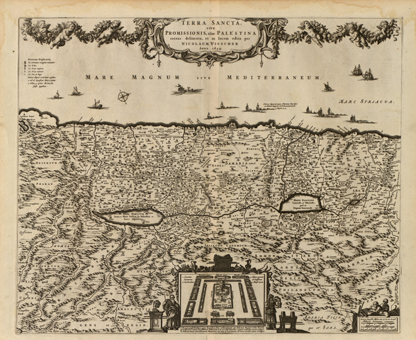
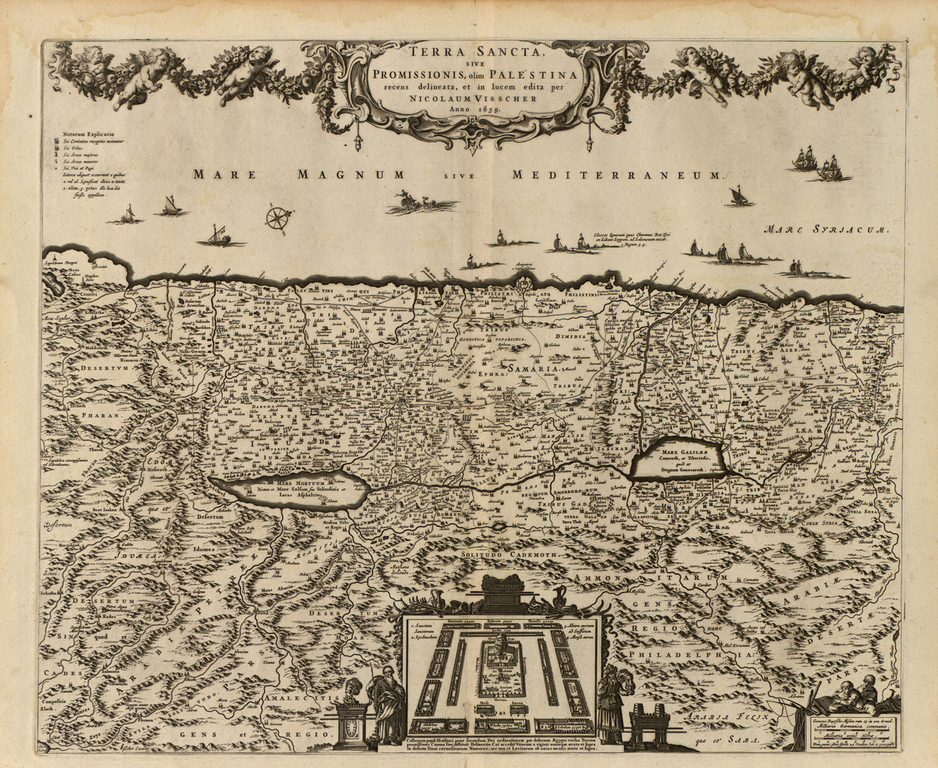
English: The Holy Land or Promised Land (Formerly Palestine), Recently Depicted and Published
中文:圣地或乐土(原巴勒斯坦) ,最近描绘与出版
Português: A Terra Santa ou Terra Prometida (antiga Palestina), descrita e publicada recentemente
العربية: ال أرض المقدسة أو أرض الميعاد (فلسطين سابقا)، مصورة ومنشورة في الآونة الأخيرة
Español: La Tierra Santa o la Tierra Prometida (ex Palestina), recientemente descrita y publicada |
| Description |
Русский: Николаус Вишер (Nicolaus Visscher, также пишется Nicolas, Nicolaes) был сыном искусного голландского художника и картографа Класа Янсзуна Вишера; составленные им карты широко известны утонченной художественностью исполнения. В XVI и XVIII веке голландцы состязались с португальцами за контроль над торговлей пряностями. Антипатия между двумя государствами особенно усугублялась тем, что Португалия вступила в альянс с Королевством Испания, с которым голландцы вели Восьмидесятилетнюю войну (1566-1648 гг.). Всего за год до появления этой карты голландцы изгнали португальцев из Шри-Ланки и предпринимали многочисленные попытки создать карты с учетом своей коммерческой и имперской экспансии. Хотя в то время Святая Земля принадлежала Оттоманской империи, голландцы, закрепившиеся в Персии, вынашивали планы по дальнейшей экспансии на Ближний Восток.
Палестина Français : Nicolaus Visscher (également écrit Nicolas ou Nicolaes), fils du maître peintre et cartographe hollandais Claes Janszoon Visscher, était réputé pour le raffinement artistique de ses cartes. Au 16ème et 17ème siècles, les Hollandais étaient engagés dans une course contre le Portugal pour le contrôle du commerce des épices.
L'antipathie entre les deux états était particulièrement profonde, suite à l'alliance du Portugal avec le Royaume d'Espagne, contre lequel les Néerlandais s'étaient battus dans la guerre de Quatre-Vingts Ans (1566-1648). Un an seulement avant la création de cette carte, les Hollandais avaient chassé les Portugais du Sri Lanka et étaient pris dans un tourbillon d'entreprises cartographiques, liées à leur forte expansion commerciale et impériale. Bien qu' à cette époque la Terre Sainte appartienne à l'Empire ottoman, les Néerlandais avaient pris pied en Perse et nourrissaient des desseins d'expansion au Proche-Orient. Palestine English: Nicolaus (also spelled Nicolas, Nicolaes) Visscher was the son of a Dutch master painter and mapmaker, Claes Janszoon Visscher, and was known for the exquisite artistry of the maps he produced. In the 16th and 17th centuries the Dutch were involved in a race against Portugal for control of the spice trade. The antipathy between the two states ran especially deep because of the alliance of Portugal with the Kingdom of Spain, with whom the Dutch had been embroiled in the Eighty Years' War (1566-1648). Only one year before the creation of this map, the Dutch had ousted the Portuguese from Sri Lanka and were engaged in a flurry of cartographic endeavors related to their commercial and imperial expansion. Although the Holy Land belonged to the Ottoman Empire at this time, the Dutch had a foothold in Persia and designs for further expansion in the Near East.
Palestine 中文:尼古拉斯·唯舒亚(拼写为 Nicolaus Visscher、Nicolas或Nicolaes),是荷兰大师级画家与制图家克拉斯·简士·唯舒亚之子,以其地图的精致艺术特性而著称。 16、17 世纪,荷兰与葡萄牙为取得对香料贸易的控制权展开竞争。 由于葡萄牙与西班牙结盟,上述两国越来越不相容,此外荷兰还卷入了与西班牙的八十年战争(1566-1648 年)。 仅在本地图创作前一年,荷兰将葡萄牙人逐出了斯里兰卡,并与其商业和帝国主义的扩张相结合,进行了一系列地图测绘事业。 尽管这片圣地当时属于奥斯曼帝国,荷兰人在波斯也有一个立足点,计划在近东进一步扩张。
巴勒斯坦 Português: Nicolaus (ou ainda Nicolas, Nicolaes) Visscher foi o filho do pintor holandês e cartógrafo, Claes Janszoon Visscher, e foi conhecido pela excelência artística dos mapas produzidos por ele. Nos séculos XVI e XVII os holandeses estavam envolvidos numa corrida contra Portugal para o controle do comércio de especiarias. A antipatia entre os dois estados se tornou particularmente profunda devido à aliança de Portugal com o Reino da Espanha, com os quais os holandeses tinham se envolvido na Guerra dos Oitenta Anos (1566-1648). Apenas um ano antes da criação deste mapa, os holandeses haviam afastado os portugueses de Sri Lanka e se envolveram numa onda de empreendimentos cartográficos relacionados com a sua expansão comercial e imperial. Embora a Terra Santa pertencesse ao Império Otomano naquela época, os holandeses tinham uma posição na Pérsia e planejavam expansões maiores no Oriente Próximo.
Palestina العربية: كان نيكولاوس فيشر (الذي ورد هجائه كنيكولاس ونيكولايس) ابن رسام وصانع خرائط هولندي بارز وهو كلايس جانزون فيشر وكان معروفا بالدقة الفنية للخرائط التي ينتجها. كان الهولنديون في القرنين السدس عشر والسابع عشر مشتركين في سباق ضد البرتغال للسيطرة على تجارة التوابل. كانت البغضاء بين الدولتين عميقة خاصة بسبب تحالف البرتغال مع مملكة أسبانيا التي تورط الهولنيون معها في حرب الثمانين عاما (1566-1648).
قبل سنة واحدة من وضع هذه الخريطة، قام الهولنديون بطرد البرتغاليين من سري لانكا وكانوا منهمكين في مساعي متعلقة برسم الخرائط مرتبطة بتوسعهم التجاري والإمبراطوري. على الرغم من أن الأرض المقدسة كانت جزءا من الإمبراطورية العثمانية في ذلك الوقت إلا أن بلاد فارس كانت موطئ قدم للهولنديين كما كانت لهم مخططات بالتوسع في الشرق الأدنى. فلسطين Español: Nicolaus (también escrito como Nicolas, Nicolaes) Visscher fue el hijo de un pintor y cartógrafo holandés, Claes Janszoon Visscher, y se hizo conocido por el exquisito arte de los mapas que produjo. En los siglos XVI y XVII los holandeses participaron en una carrera contra Portugal por el control del comercio de especias. La antipatía entre los dos estados se agudizó a causa de la alianza de Portugal con el Reino de España, con el que los holandeses se habían visto enfrentados en La Guerra de los Ochenta Años (1566-1648). Solo un año antes de la creación de este mapa, los holandeses habían desplazado a los portugueses de Sri Lanka y participaban en una serie de iniciativas cartográficas relacionadas con la expansión imperial y comercial. A pesar de que la Tierra Santa pertenecía al Imperio otomano en ese momento, los holandeses tenían un punto de apoyo en Persia y proyectaban una futura expansión en el Cercano Oriente.
Palestina |
| Date | 1659 |
| Medium |
Русский: Карты
Français : Cartes
English: Maps
中文:地图
Português: Mapas
العربية: خرائط
Español: Mapas |
| Dimensions |
English: 1 map ; 47 x 57 centimeters |
| Collection |
Русский: Библиотека Конгресса
Français : Bibliothèque du Congrès
English: Library of Congress
中文:国会图书馆
Português: Biblioteca do Congresso
العربية: مكتبة الكونغرس
Español: Biblioteca del Congreso |
| Place of creation |
Русский: Израиль
Français : Israël
English: Israel
中文:以色列
Português: Israel
العربية: إسرائيل
Español: Israel |
| Notes | Original language title: Terra sancta sive promissionis, olim Palestina recens delineata, et in lucem edita per Nicolaum Visscher |
| References | http://hdl.loc.gov/loc.wdl/dlc.210 |
| Source/Photographer |
|
Licensing
edit,_Recently_Depicted_and_Published_WDL210.png&action=edit§ion=2)
|
This is a faithful photographic reproduction of a two-dimensional, public domain work of art. The work of art itself is in the public domain for the following reason:
The official position taken by the Wikimedia Foundation is that "faithful reproductions of two-dimensional public domain works of art are public domain".
This photographic reproduction is therefore also considered to be in the public domain in the United States. In other jurisdictions, re-use of this content may be restricted; see Reuse of PD-Art photographs for details. | ||||
File history
Click on a date/time to view the file as it appeared at that time.
| Date/Time | Thumbnail | Dimensions | User | Comment | |
|---|---|---|---|---|---|
| current | 04:42, 11 March 2014 | | 1,251 × 1,024 (2.68 MB) | Fæ (talk | contribs) | =={{int:filedesc}}== {{Artwork |artist = |author ={{ru|1=Вишер, Николас (1618-1679)}} {{fr|1=Visscher, Nicolaes (1618-1679)}} {{en|1=Visscher, Nicolaes (1618-1679)}} {{zh|1=韦雪尔, 尼克拉斯 (1618-1679)}} {{pt|1=Visscher, Nicolaes (16... |
You cannot overwrite this file.
File usage on Commons
The following page uses this file:
,_Recently_Depicted_and_Published_WDL210.png)
,_Recently_Depicted_and_Published_WDL210.png&oldid=853243978)