File:The Kingdom of France is represented under the form of a ship. LOC 91680104.jpg

Size of this preview: 800 × 485 pixels. Other resolutions: 320 × 194 pixels | 640 × 388 pixels | 1,024 × 621 pixels | 1,280 × 776 pixels | 2,560 × 1,552 pixels | 11,550 × 7,001 pixels.
Original file (11,550 × 7,001 pixels, file size: 16.63 MB, MIME type: image/jpeg)
Captions
Captions
Add a one-line explanation of what this file represents
Summary
edit| Warning | The original file is very high-resolution. It might not load properly or could cause your browser to freeze when opened at full size. |
|---|
| Description |
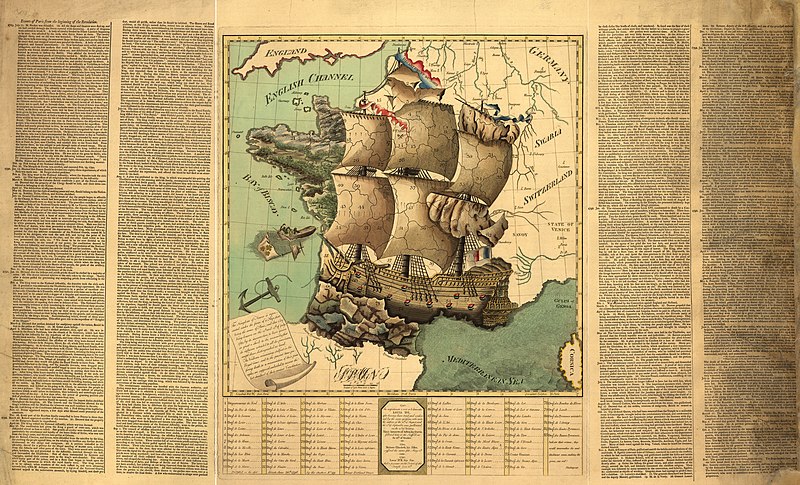
English: Cartoon map showing monarchical France in the form of a sailing ship at sea. Relief shown pictorially. Also shows administrative divisions (departments). Text, calendar, and map names in English. Index of departments in French. Title from first sentence of text at lower left. "Published as the act directs, June 28th 1796, by the author, no. 49 Great Portland Street." Paris meridian. Watermark: 1794 J. Whatman. Available also through the Library of Congress Web site as a raster image. Includes text, index of departments, and extensive calendar of "Events of Paris from the beginning of the Revolution" thru Dec. 1795 in right and left margins. LC copy torn, taped, and missing lower right corner of calendar of events. Vault Acquisitions control no. 91-13 |
||
| Title | The Kingdom of France is represented under the form of a ship. | ||
| Shelf ID | G5831.A5 1795 .K5 | ||
| Date | |||
| Source | https://www.loc.gov/item/91680104/ | ||
| Author | Unknown author | ||
| Permission (Reusing this file) |
|
||
| Other versions |
|
||
| Location | France | ||
| Part of | American Memory · General Maps · Catalog · Geography And Map Division | ||
| Subject | Revolution · Maps, Pictorial · France · Maps · Early Works To 1800 · Administrative And Political Divisions · History |


Licensing
edit
|
This is a faithful photographic reproduction of a two-dimensional, public domain work of art. The work of art itself is in the public domain for the following reason:
The official position taken by the Wikimedia Foundation is that "faithful reproductions of two-dimensional public domain works of art are public domain".
This photographic reproduction is therefore also considered to be in the public domain in the United States. In other jurisdictions, re-use of this content may be restricted; see Reuse of PD-Art photographs for details. | ||||
File history
Click on a date/time to view the file as it appeared at that time.
| Date/Time | Thumbnail | Dimensions | User | Comment | |
|---|---|---|---|---|---|
| current | 07:03, 30 May 2018 | | 11,550 × 7,001 (16.63 MB) | Fæ (talk | contribs) | LOC Maps https://www.loc.gov/item/91680104/ #2529 |
You cannot overwrite this file.
File usage on Commons
The following page uses this file: