File:The Santa Fé route Atchison, Topeka & Santa Fé R.R. 3 lines between the Missouri River and the Pacific coast to the city of Mexico via the A.T.&S. and Mexican Central R.R. LOC 98688580.jpg

Size of this preview: 800 × 332 pixels. Other resolutions: 320 × 133 pixels | 640 × 265 pixels | 1,024 × 424 pixels | 1,280 × 530 pixels | 2,560 × 1,061 pixels | 11,968 × 4,960 pixels.
Original file (11,968 × 4,960 pixels, file size: 13.25 MB, MIME type: image/jpeg)
Captions
Captions
Add a one-line explanation of what this file represents
Summary
edit| Description |
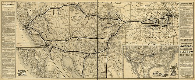
English: Map of the western United States from Kansas City to the Pacific showing relief by shading, drainage, state boundaries, military and Indian reservations, railroads with main lines in heavy black; lists stage connections on each side of map. |
||
| Title | The Santa Fé route Atchison, Topeka & Santa Fé R.R. 3 lines between the Missouri River and the Pacific coast to the city of Mexico via the A.T.&S. and Mexican Central R.R. | ||
| Shelf ID | G4051.P3 1884 .P6 | ||
| Date | |||
| Source | https://www.loc.gov/item/98688580/ | ||
| Author | Poole Brothers; Atchison, Topeka, And Santa Fe Railroad Company | ||
| Permission (Reusing this file) |
|
||
| Location | United States · West | ||
| Part of | American Memory · Catalog · Railroad Maps, 1828-1900 · Geography And Map Division · Transportation And Communication | ||
| Subject | Railroads · West · Atchison, Topeka, And Santa Fe Railroad Company · West (U.S.) · United States · Maps |

Licensing
edit
|
This is a faithful photographic reproduction of a two-dimensional, public domain work of art. The work of art itself is in the public domain for the following reason:
The official position taken by the Wikimedia Foundation is that "faithful reproductions of two-dimensional public domain works of art are public domain".
This photographic reproduction is therefore also considered to be in the public domain in the United States. In other jurisdictions, re-use of this content may be restricted; see Reuse of PD-Art photographs for details. | ||||
File history
Click on a date/time to view the file as it appeared at that time.
| Date/Time | Thumbnail | Dimensions | User | Comment | |
|---|---|---|---|---|---|
| current | 09:49, 16 May 2018 | | 11,968 × 4,960 (13.25 MB) | Fæ (talk | contribs) | LOC Maps https://www.loc.gov/item/98688580/ #992 |
You cannot overwrite this file.
File usage on Commons
There are no pages that use this file.