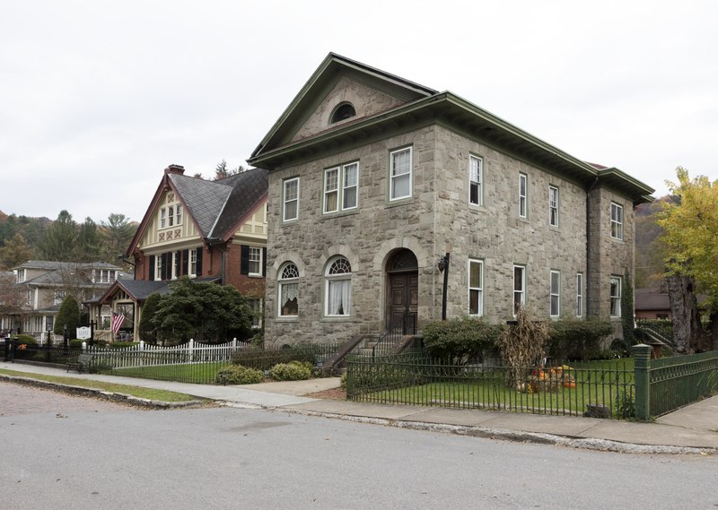
File:The elegant residential section of Main Strreet in Bramwell, known as the "Millionaires' Town in West Virginia's Southern Coalfields," which extended for 40 miles from Bramwell, which, it is said, LCCN2015634394.tif

Size of this JPG preview of this TIF file: 800 × 569 pixels. Other resolutions: 320 × 228 pixels | 640 × 455 pixels | 1,024 × 729 pixels | 1,280 × 911 pixels | 2,560 × 1,821 pixels | 7,462 × 5,309 pixels.
Original file (7,462 × 5,309 pixels, file size: 226.72 MB, MIME type: image/tiff)
Captions
Captions
Add a one-line explanation of what this file represents
Summary edit
| Description |
English: Title: The elegant residential section of Main Street in Bramwell, known as the "Millionaires' Town in West Virginia's Southern Coalfields," which extended for 40 miles from Bramwell, which, it is said, once housed more millionaires per capita than any other town in America in the late 1800s
Physical description: 1 photograph : digital, tiff file, color. Notes: The rich Pochahontas coal fields, employing more than 100,000 miners, started in Bramwell and spread over forty miles. At one time, the Norfolk & Western railroad ran 14 trains a day through town. Shown are the 1893 Bank of Bramwell building (right) and the Perry House next door, built by the bank and occupied for many years by one of its first cashiers, J.B. Perry, and his family.; Credit line: West Virginia Collection within the Carol M. Highsmith Archive, Library of Congress, Prints and Photographs Division.; Forms part of: West Virginia Collection within the Carol M. Highsmith Archive.; Title, date and keywords based on information provided by the photographer.; Purchase; Carol M. Highsmith Photography, Inc.; 2015; (DLC/PP-2015:055). |
||||||||||||||||||||||||||
| Date | Taken on 24 October 2015, 13:48 (according to Exif data) | ||||||||||||||||||||||||||
| Source |
Library of Congress
|
||||||||||||||||||||||||||
| Author |
|
||||||||||||||||||||||||||
| Permission (Reusing this file) |
No known restrictions on publication.
|
||||||||||||||||||||||||||


Licensing edit
| This work is from the Carol M. Highsmith Archive collection at the Library of Congress. According to the library, there are no known copyright restrictions on the use of this work. Carol M. Highsmith has stipulated that her photographs are in the public domain. Photographs of sculpture or other works of art may be restricted by the copyright of the artist. |
 |
File history
Click on a date/time to view the file as it appeared at that time.
| Date/Time | Thumbnail | Dimensions | User | Comment | |
|---|---|---|---|---|---|
| current | 05:25, 19 September 2016 |  | 7,462 × 5,309 (226.72 MB) | Fæ (talk | contribs) | LOC 2015634394, Carol M. Highsmith collection. P588.15329 TIFF (226.7mb) |
| 05:25, 19 September 2016 |  | 7,462 × 5,309 (226.72 MB) | Fæ (talk | contribs) | LOC 2015634394, Carol M. Highsmith collection. P588.15329 TIFF (226.7mb) |
You cannot overwrite this file.
File usage on Commons
There are no pages that use this file.