File:The former Yugoslav republic of Macedonia, summary map LOC 94683825.tif

Size of this JPG preview of this TIF file: 800 × 502 pixels. Other resolutions: 320 × 201 pixels | 640 × 402 pixels | 1,024 × 642 pixels | 1,280 × 803 pixels | 2,560 × 1,606 pixels | 7,389 × 4,636 pixels.
Original file (7,389 × 4,636 pixels, file size: 98.01 MB, MIME type: image/tiff)
Captions
Captions
Add a one-line explanation of what this file represents
Summary
edit| Description |
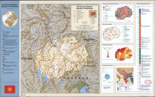
English: "802207 (R01142) 2-94". Relief shown by shading and spot heights. Panel title. Title at upper right: The former Yugoslav republic of Macedonia. Includes text, population graph, graph of "Eras of historical control", inset comparative-area diagram, and col. ill. of flag. Ancillary maps: [Location map] -- Land use and natural resources -- Economic activity -- Population density -- Controlling empire [historical]. Available also through the Library of Congress Web site as a raster image. |
||
| Title | The former Yugoslav republic of Macedonia, summary map | ||
| Shelf ID | G6845 1994 .U5 | ||
| Date | |||
| Source | https://www.loc.gov/item/94683825/ | ||
| Author | United States. Central Intelligence Agency | ||
| Permission (Reusing this file) |
|
||
| Other versions |
|
||
| Location | Republic · Macedonia | ||
| Part of | American Memory · Places In The News Archive · Catalog · Geography And Map Division · General Maps | ||
| Subject | Charts, Diagrams, Etc · Land Use · Macedonia (Republic) · Macedonia · Maps · Population Density · Maps, Physical · Territory, National · Economic Conditions · History |


Licensing
edit| This image is a work of a Central Intelligence Agency employee, taken or made as part of that person's official duties. As a Work of the United States Government, this image or media is in the public domain in the United States.
|

|
File history
Click on a date/time to view the file as it appeared at that time.
| Date/Time | Thumbnail | Dimensions | User | Comment | |
|---|---|---|---|---|---|
| current | 21:22, 18 May 2018 |  | 7,389 × 4,636 (98.01 MB) | Fæ (talk | contribs) | LOC Maps https://www.loc.gov/item/94683825/ #2009 |
You cannot overwrite this file.
File usage on Commons
The following page uses this file: