File:The gold and coal fields of Alaska - together with the principal steamer routes and trails LOC 2006629762.jpg

Size of this preview: 756 × 599 pixels. Other resolutions: 303 × 240 pixels | 605 × 480 pixels | 969 × 768 pixels | 1,280 × 1,015 pixels | 2,560 × 2,030 pixels | 9,049 × 7,175 pixels.
Original file (9,049 × 7,175 pixels, file size: 8.96 MB, MIME type: image/jpeg)
Captions
Captions
Add a one-line explanation of what this file represents
Summary edit
| Description |
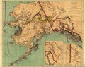
English: Relief shown in hachures. Includes parts of the Yukon Territory and northern British Columbia. Includes 2 inset maps: The Klondike gold field, Canada -- Trails from Tide Water to the headwaters of the Yukon River, Alaska. Accompanied by: Map of Alaska : showing known gold-bearing rocks ... Washington, D.C. : United States Geological Survey, 1898. 44 p. Available also through the Library of Congress Web site as a raster image. |
||
| Title | The gold and coal fields of Alaska : together with the principal steamer routes and trails | ||
| Shelf ID | G4371.H1 1898 .U5 G4371.H1 1898 .U5 G4371.H1 1898 .U5 | ||
| Date | |||
| Source | https://www.loc.gov/item/2006629762/ | ||
| Author | Geological Survey (U.S.) | ||
| Permission (Reusing this file) |
|
||
| Other versions |
|
||
| Location | United States · Alaska | ||
| Part of | American Memory · Catalog · Geography And Map Division · Additional Conservation And Environment Cartographic Items | ||
| Subject | Gold · Coal · Trails · Alaska · United States · Maps · Steamboat Lines |

Licensing edit
|
This is a faithful photographic reproduction of a two-dimensional, public domain work of art. The work of art itself is in the public domain for the following reason:
The official position taken by the Wikimedia Foundation is that "faithful reproductions of two-dimensional public domain works of art are public domain".
This photographic reproduction is therefore also considered to be in the public domain in the United States. In other jurisdictions, re-use of this content may be restricted; see Reuse of PD-Art photographs for details. | ||||
File history
Click on a date/time to view the file as it appeared at that time.
| Date/Time | Thumbnail | Dimensions | User | Comment | |
|---|---|---|---|---|---|
| current | 15:07, 5 August 2018 | | 9,049 × 7,175 (8.96 MB) | Fæ (talk | contribs) | LOC Maps https://www.loc.gov/item/2006629762/ #23284 |
You cannot overwrite this file.
File usage on Commons
The following 2 pages use this file: