File:This survey of the River Patapsco and part of Chesapeake Bay, LOC 76697578.tif

Size of this JPG preview of this TIF file: 343 × 598 pixels. Other resolutions: 137 × 240 pixels | 275 × 480 pixels | 440 × 768 pixels | 587 × 1,024 pixels | 1,174 × 2,048 pixels | 5,802 × 10,121 pixels.
Original file (5,802 × 10,121 pixels, file size: 168.01 MB, MIME type: image/tiff)
Captions
Captions
Add a one-line explanation of what this file represents
Summary
edit| Description |
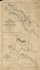
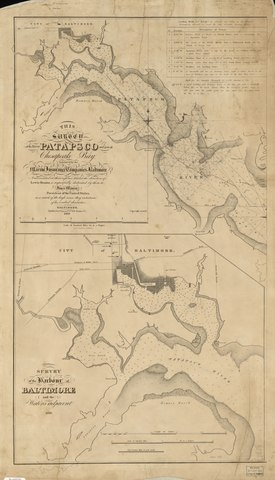
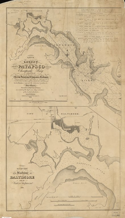
English: Scale ca. 1:40,960. Depths shown by shading and soundings. LC copy annotated in pencil. LC copy incomplete: Additional sheet showing the southern section of Patapsco River, the Chesapeake Bay, and the inset of Annapolis Harbor missing. Includes notes, "Description of ranges," and "Survey of the harbour of Baltimore and the waters adjacent." Available also through the Library of Congress Web site as a raster image. Vault AACR2 |
||
| Title | This survey of the River Patapsco and part of Chesapeake Bay, | ||
| Shelf ID | G3842.P34 1819 .B74 | ||
| Date | |||
| Source | https://www.loc.gov/item/76697578/ | ||
| Author | Brantz, Lewis; Lucas, Fielding | ||
| Permission (Reusing this file) |
|
||
| Other versions |
|
||
| Location | United States · Maryland · Patapsco River · Baltimore | ||
| Part of | American Memory · General Maps · Catalog · Geography And Map Division | ||
| Subject | Patapsco River · United States · Maps · Harbors · Patapsco River (Md.) · Maryland · Baltimore |


Licensing
edit|
This is a faithful photographic reproduction of a two-dimensional, public domain work of art. The work of art itself is in the public domain for the following reason:
The official position taken by the Wikimedia Foundation is that "faithful reproductions of two-dimensional public domain works of art are public domain".
This photographic reproduction is therefore also considered to be in the public domain in the United States. In other jurisdictions, re-use of this content may be restricted; see Reuse of PD-Art photographs for details. | ||||
File history
Click on a date/time to view the file as it appeared at that time.
| Date/Time | Thumbnail | Dimensions | User | Comment | |
|---|---|---|---|---|---|
| current | 16:20, 25 June 2018 |  | 5,802 × 10,121 (168.01 MB) | Fæ (talk | contribs) | LOC Maps https://www.loc.gov/item/76697578/ #28199 |
You cannot overwrite this file.
File usage on Commons
The following page uses this file: