File:Topographical map of Pike County, Pennsylvania - from recent and actual surveys and records LOC 2012592196.tif

Size of this JPG preview of this TIF file: 457 × 599 pixels. Other resolutions: 183 × 240 pixels | 366 × 480 pixels | 586 × 768 pixels | 781 × 1,024 pixels | 1,563 × 2,048 pixels | 13,861 × 18,160 pixels.
Original file (13,861 × 18,160 pixels, file size: 720.16 MB, MIME type: image/tiff)
Captions
Captions
Add a one-line explanation of what this file represents
Summary
edit| Warning | The original file is very high-resolution. It might not load properly or could cause your browser to freeze when opened at full size. |
|---|
| Description |
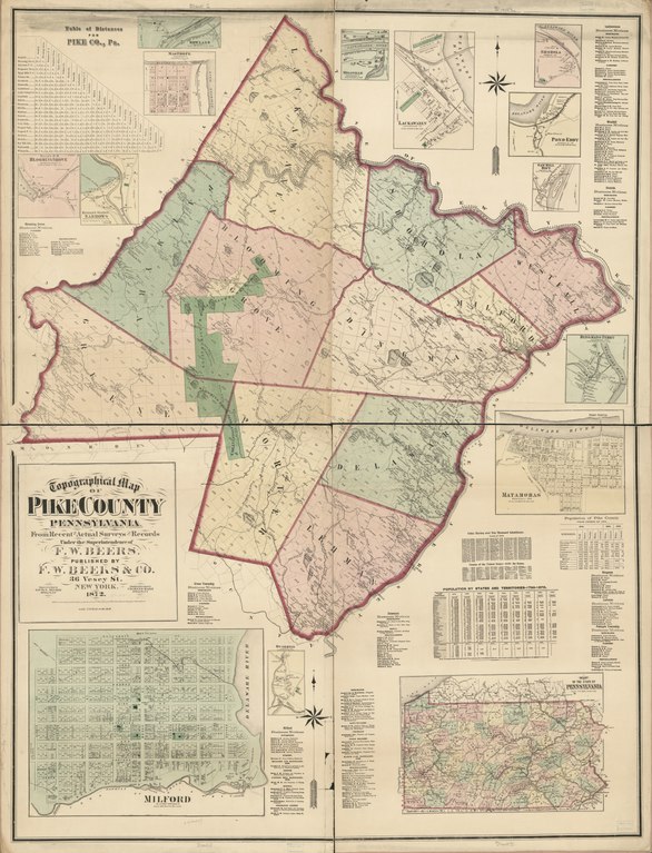
English: County cadastral map showing townships, warranty-deed land tracts, warranty numbers, real-property tracts, some landowners' names, park lands, rural buildings, and householders' names; borough insets show property tracts (lots), lot numbers, owners' names, and building coverage. Hand col. to emphasize township boundaries, townships territories, and park lands. "Entered according to Act of Congress in the Year 1872 by F.W. Beers & Co. in the Office of the Librarian of Congress at Washington D.C." LC copy imperfect: Annotated in lead pencil, brittle, missing small sections along inner edges, cloth hemmed. Includes inset "Map of the state of Pennsylvania", population statistical tables, distance table, local business directories, and 13 village/borough insets (including Milford and Matamoras). LC Land ownership maps, 786 Available also through the Library of Congress Web site as a raster image. 2 copies |
||
| Title | Topographical map of Pike County, Pennsylvania : from recent and actual surveys and records | ||
| Shelf ID | G3823.P5G46 1872 .B4 | ||
| Date | |||
| Source | https://www.loc.gov/item/2012592196/ | ||
| Author | Beers, F. W. (Frederick W.); Neumann, Louis E.; Hart, Chas. (Charles); F.W. Beers & Co.; Beers, F. W. | ||
| Permission (Reusing this file) |
|
||
| Other versions |
|
||
| Location | Milford · Pennsylvania · Pike County · United States · Milford (Pike County) · Matamoras · Matamoras (Pike County) | ||
| Part of | American Memory · Catalog · County Landownership Maps · Geography And Map Division · Cultural Landscapes | ||
| Subject | Cadastral Maps · Matamoras (Pike County, Pa.) · Parks · Pennsylvania · Cities And Towns · Villages · Warranty Of Title · Topographic Maps · Pike County · United States · Maps · Milford (Pike County, Pa.) · Matamoras (Pike County) · Pike County (Pa.) · Real Property · Landowners · Milford (Pike County) |


Licensing
edit|
This is a faithful photographic reproduction of a two-dimensional, public domain work of art. The work of art itself is in the public domain for the following reason:
The official position taken by the Wikimedia Foundation is that "faithful reproductions of two-dimensional public domain works of art are public domain".
This photographic reproduction is therefore also considered to be in the public domain in the United States. In other jurisdictions, re-use of this content may be restricted; see Reuse of PD-Art photographs for details. | ||||
File history
Click on a date/time to view the file as it appeared at that time.
| Date/Time | Thumbnail | Dimensions | User | Comment | |
|---|---|---|---|---|---|
| current | 14:40, 4 June 2018 |  | 13,861 × 18,160 (720.16 MB) | Fæ (talk | contribs) | LOC Maps https://www.loc.gov/item/2012592196/ #4649 |
You cannot overwrite this file.
File usage on Commons
The following page uses this file: