File:Valley Forge LOC 2011587730.tif

Size of this JPG preview of this TIF file: 800 × 377 pixels. Other resolutions: 320 × 151 pixels | 640 × 301 pixels | 1,024 × 482 pixels | 1,280 × 602 pixels | 2,560 × 1,205 pixels | 10,152 × 4,778 pixels.
Original file (10,152 × 4,778 pixels, file size: 138.78 MB, MIME type: image/tiff)
Captions
Captions
Add a one-line explanation of what this file represents
Summary edit
| Description |
English: "*GPO:2011--365-615/80642 Reprint 2011." Also shows designated tour route. Title from panel. Includes text, descriptive index to points of interest, and col. ill. Text, regional map of 1777 troop movements, and col. ill. on verso. Available also through the Library of Congress Web site as a raster image. |
||
| Title | Valley Forge | ||
| Shelf ID | G3822.V3 2011 .U5 | ||
| Date | |||
| Source | https://www.loc.gov/item/2011587730/ | ||
| Author | United States. National Park Service | ||
| Permission (Reusing this file) |
|
||
| Other versions |
|
||
| Location | Pennsylvania · United States · Valley Forge National Historical Park. · Valley Forge National Historical Park | ||
| Part of | American Memory · General Maps · Catalog · Geography And Map Division | ||
| Subject | Valley Forge National Historical Park · Pennsylvania · United States · Maps · Tourist Maps · Tours · Valley Forge National Historical Park (Pa.) |


Licensing edit
| This image or media file contains material based on a work of a National Park Service employee, created as part of that person's official duties. As a work of the U.S. federal government, such work is in the public domain in the United States. See the NPS website and NPS copyright policy for more information. |
File history
Click on a date/time to view the file as it appeared at that time.
| Date/Time | Thumbnail | Dimensions | User | Comment | |
|---|---|---|---|---|---|
| current | 06:24, 31 May 2018 | 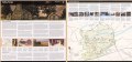 | 10,152 × 4,778 (138.78 MB) | Fæ (talk | contribs) | LOC Maps https://www.loc.gov/item/2011587730/ #16017 |
You cannot overwrite this file.
File usage on Commons
The following page uses this file: