File:Vicksburg National Military Park, Mississippi. LOC 99448521.tif

Size of this JPG preview of this TIF file: 633 × 599 pixels. Other resolutions: 254 × 240 pixels | 507 × 480 pixels | 811 × 768 pixels | 1,082 × 1,024 pixels | 2,163 × 2,048 pixels | 4,468 × 4,230 pixels.
Original file (4,468 × 4,230 pixels, file size: 54.07 MB, MIME type: image/tiff)
Captions
Captions
Add a one-line explanation of what this file represents
Summary
edit| Description |
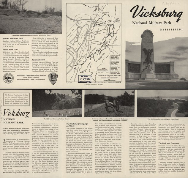
English: Scale ca. 1:62,000. LC Civil War Maps (2nd ed.), 291.1 Descriptive leaflet illustrated with the following two maps: [a] Vicksburg National Military Park, Mississippi. Colored. Scale ca. 1:14,400. 11 x 22 cm. (Shows names of commander roads, railroad, and tour route.) [b] The Vicksburg campaign. Aug. 1962. Colored. Scale ca. 1:2,350,000. 40 x 23 cm. (Map of the Mississippi River from Memphis to the Gulf of Mexico showing drainage, railroads, and towns.) Description derived from published bibliography. Available also through the Library of Congress web site as raster image. |
||
| Title | Vicksburg National Military Park, Mississippi. | ||
| Shelf ID | G3984.V8 1958 .U5 | ||
| Date | |||
| Source | https://www.loc.gov/item/99448521/ | ||
| Author | United States. National Park Service | ||
| Permission (Reusing this file) |
|
||
| Other versions |
|
||
| Location | United States · Mississippi · Vicksburg National Military Park | ||
| Part of | Military Battles And Campaigns · American Memory · Civil War Maps · Catalog · Geography And Map Division | ||
| Subject | Vicksburg National Military Park (Miss.) · United States · Mississippi · Vicksburg National Military Park |


Licensing
edit| This image or media file contains material based on a work of a National Park Service employee, created as part of that person's official duties. As a work of the U.S. federal government, such work is in the public domain in the United States. See the NPS website and NPS copyright policy for more information. |
File history
Click on a date/time to view the file as it appeared at that time.
| Date/Time | Thumbnail | Dimensions | User | Comment | |
|---|---|---|---|---|---|
| current | 10:14, 1 August 2018 |  | 4,468 × 4,230 (54.07 MB) | Fæ (talk | contribs) | LOC Maps https://www.loc.gov/item/99448521/ #18327 |
You cannot overwrite this file.
File usage on Commons
The following page uses this file: