File:View of the Margaret Hunt Hill Bridge, a Santiago Calatrava-designed bridge over the Trinity River in Dallas, Texas LCCN2014632135.tif

Size of this JPG preview of this TIF file: 800 × 449 pixels. Other resolutions: 320 × 180 pixels | 640 × 359 pixels | 1,024 × 575 pixels | 1,280 × 719 pixels | 2,560 × 1,438 pixels | 6,559 × 3,684 pixels.
Original file (6,559 × 3,684 pixels, file size: 164.55 MB, MIME type: image/tiff)
Captions
Captions
Add a one-line explanation of what this file represents
Summary
edit| Description |
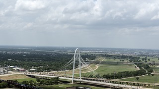
English: Title: View of the Margaret Hunt Hill Bridge, a Santiago Calatrava-designed bridge over the Trinity River in Dallas, Texas
Physical description: 1 photograph : digital, tiff file, color. Notes: The bridge is named for Margaret Hunt Hill, a Dallas entrepreneur and philanthropist, who was the daughter of legendary oilman H.L. Hunt.Construction on the bridge began in spring 2007 with the steel manufactured in an Italian steel factory often used by Calatrava to realize his designs. It connects Texas Spur 366 (the Woodall Rodgers Freeway) downtown to Singleton Boulevard in west Dallas.; Title, date, and keywords based on information provided by the photographer.; Gift; The Lyda Hill Foundation; 2014; (DLC/PP-2014:054).; Forms part of: Lyda Hill Texas Collection of Photographs in Carol M. Highsmith's America Project in the Carol M. Highsmith Archive.; Credit line: The Lyda Hill Texas Collection of Photographs in Carol M. Highsmith's America Project, Library of Congress, Prints and Photographs Division. |
||||||||||||||||||||||||||
| Date | Taken on 11 May 2014, 14:26 (according to Exif data) | ||||||||||||||||||||||||||
| Source |
Library of Congress
|
||||||||||||||||||||||||||
| Author |
|
||||||||||||||||||||||||||
| Permission (Reusing this file) |
No known restrictions on publication.
|
||||||||||||||||||||||||||


| Camera location | | View this and other nearby images on: OpenStreetMap |
|---|
Licensing
edit| This work is from the Carol M. Highsmith Archive collection at the Library of Congress. According to the library, there are no known copyright restrictions on the use of this work. Carol M. Highsmith has stipulated that her photographs are in the public domain. Photographs of sculpture or other works of art may be restricted by the copyright of the artist; see Commons:FOP US#Artworks and sculptures for more information. |
 |
File history
Click on a date/time to view the file as it appeared at that time.
| Date/Time | Thumbnail | Dimensions | User | Comment | |
|---|---|---|---|---|---|
| current | 06:47, 27 September 2016 |  | 6,559 × 3,684 (164.55 MB) | Fæ (talk | contribs) | LOC 2014632135, Carol M. Highsmith collection. P727.21849 TIFF (164.5mb) |
You cannot overwrite this file.
File usage on Commons
There are no pages that use this file.
File usage on other wikis
The following other wikis use this file:
- Usage on ja.wikipedia.org