File:Washington, property of Sidney Bieber and heirs showing portion there of occupied by tracks of P.B & W.R.R. Co. LOC 88690705.tif

Size of this JPG preview of this TIF file: 800 × 297 pixels. Other resolutions: 320 × 119 pixels | 640 × 237 pixels | 1,024 × 380 pixels | 1,280 × 474 pixels | 2,560 × 949 pixels | 20,794 × 7,707 pixels.
Original file (20,794 × 7,707 pixels, file size: 458.51 MB, MIME type: image/tiff)
Captions
Captions
Add a one-line explanation of what this file represents
Summary edit
| Warning | The original file is very high-resolution. It might not load properly or could cause your browser to freeze when opened at full size. |
|---|
| Description |
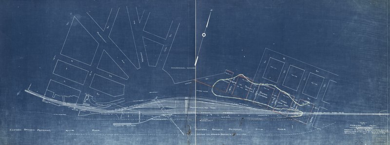
English: Covers part of area now occupied by Congressional Cemetery, Barney Circle S.E., and Conrail right-of-way. Partial cadastral map. Blueprint. "P.A.E. Wilm. 11-5-'06." "5649." "14-A." Available also through the Library of Congress Web site as a raster image. Annotated in red and yellow pencil to indicate Sidney Bieber's property and "High water line." Halved and mounted on cloth backing. DCP |
||
| Title | Washington, property of Sidney Bieber and heirs showing portion there of occupied by tracks of P.B & W.R.R. Co. | ||
| Shelf ID | G3852.C67G46 1906 .P4 | ||
| Date | |||
| Source | https://www.loc.gov/item/88690705/ | ||
| Author | Philadelphia, Baltimore & Washington Railroad Company. Maryland Division; Bieber, Sidney | ||
| Permission (Reusing this file) |
|
||
| Other versions |
|
||
| Location | Washington D.C. · Barney Circle · Washington · United States · District Of Columbia · Congressional Cemetery | ||
| Part of | American Memory · Catalog · Transportation And Communication · Geography And Map Division | ||
| Subject | Washington (D.C.) · Surveys · Barney Circle (Washington, D.C.) · Washington · Railroads · United States · Maps · District Of Columbia · Congressional Cemetery (Washington, D.C.) · Real Property |

Licensing edit
|
This is a faithful photographic reproduction of a two-dimensional, public domain work of art. The work of art itself is in the public domain for the following reason:
The official position taken by the Wikimedia Foundation is that "faithful reproductions of two-dimensional public domain works of art are public domain".
This photographic reproduction is therefore also considered to be in the public domain in the United States. In other jurisdictions, re-use of this content may be restricted; see Reuse of PD-Art photographs for details. | ||||
File history
Click on a date/time to view the file as it appeared at that time.
| Date/Time | Thumbnail | Dimensions | User | Comment | |
|---|---|---|---|---|---|
| current | 16:24, 21 July 2018 | 20,794 × 7,707 (458.51 MB) | Fæ (talk | contribs) | LOC Maps https://www.loc.gov/item/88690705/ #7241 |
You cannot overwrite this file.
File usage on Commons
The following page uses this file: