File:William Rea Furlong map collection. LOC 2016586588-1.jpg

Size of this preview: 538 × 600 pixels. Other resolutions: 215 × 240 pixels | 431 × 480 pixels | 689 × 768 pixels | 919 × 1,024 pixels | 1,837 × 2,048 pixels | 9,163 × 10,214 pixels.
Original file (9,163 × 10,214 pixels, file size: 10.04 MB, MIME type: image/jpeg)
Captions
Captions
Add a one-line explanation of what this file represents
Summary
edit| Warning | The original file is very high-resolution. It might not load properly or could cause your browser to freeze when opened at full size. |
|---|
| Description |
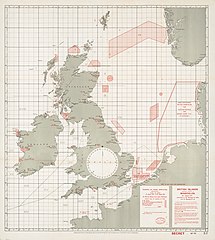
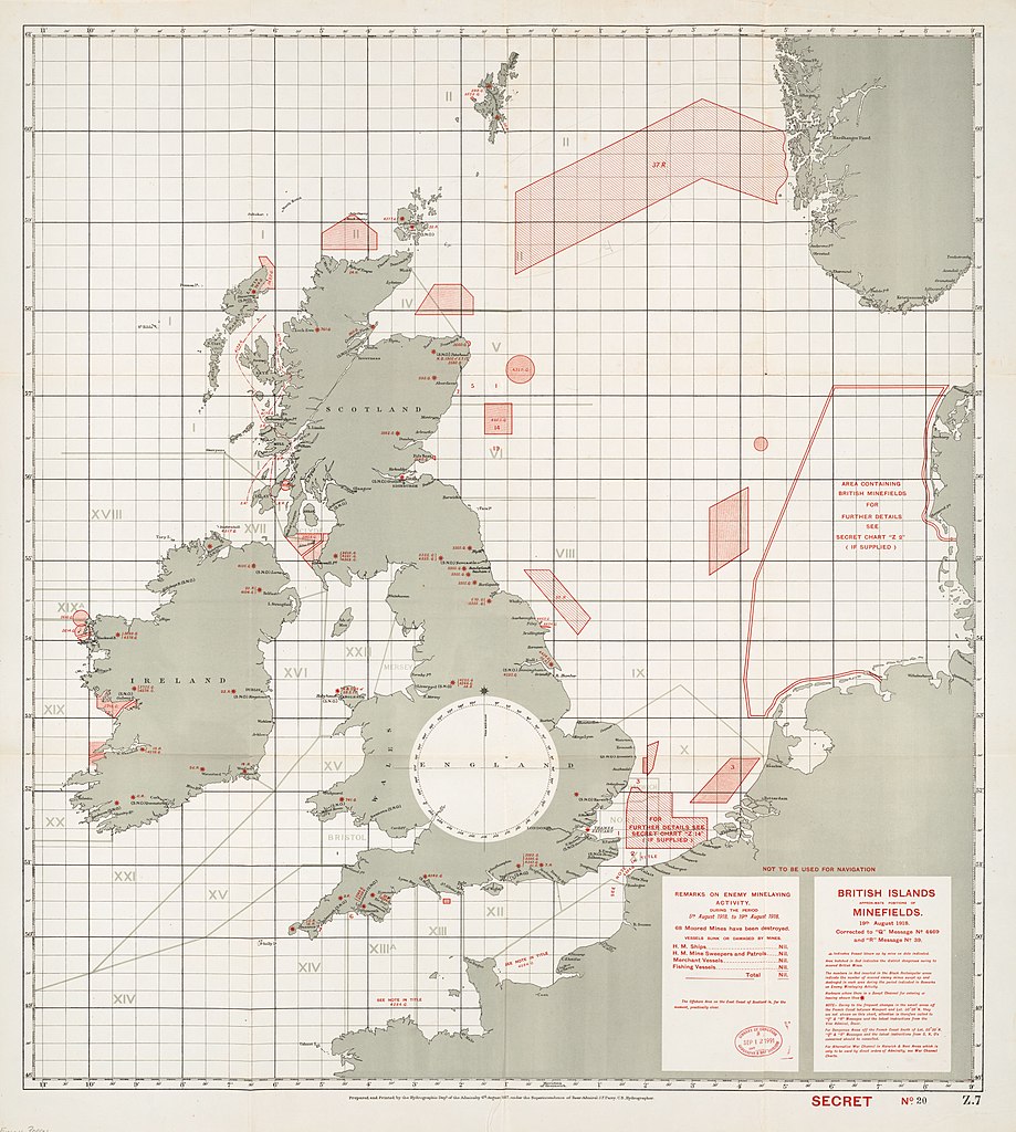
English: William Rea Furlong was a United States Navy Rear Admiral during World War II, who also served in the Navy during World War I. The collection consists of World War I-era maps and charts. One chart from 1918 depicts German and British minefields along the coast of England and a portion of continental Europe. Other items are nautical charts of Aegean Sea with annotations. |
||
| Title | William Rea Furlong map collection. | ||
| Shelf ID | G5701.S65 coll .F8 | ||
| Parent | https://www.loc.gov/resource/g5701sm.gct00412/ | ||
| Sheet title | British Islands approximate positions of minfields. 19th August 1918. | ||
| Date | |||
| Source | https://www.loc.gov/item/2016586588/ | ||
| Author | Furlong, William Rea; Great Britain. Hydrographic Department | ||
| Permission (Reusing this file) |
|
||
| Other versions |
|
||
| Location | Europe · North Sea. · Aegean Sea. · North Sea · France · Europe. · Aegean Sea | ||
| Part of | Military Battles And Campaigns · American Memory · Catalog · Geography And Map Division | ||
| Subject | Europe · North Sea · Military Maps · Railroads · France · Maps · World War · Aegean Sea · Manuscript Maps |


Licensing
edit
|
This is a faithful photographic reproduction of a two-dimensional, public domain work of art. The work of art itself is in the public domain for the following reason:
The official position taken by the Wikimedia Foundation is that "faithful reproductions of two-dimensional public domain works of art are public domain".
This photographic reproduction is therefore also considered to be in the public domain in the United States. In other jurisdictions, re-use of this content may be restricted; see Reuse of PD-Art photographs for details. | ||||
File history
Click on a date/time to view the file as it appeared at that time.
| Date/Time | Thumbnail | Dimensions | User | Comment | |
|---|---|---|---|---|---|
| current | 00:27, 15 July 2018 | | 9,163 × 10,214 (10.04 MB) | Fæ (talk | contribs) | LOC Maps multisheet https://www.loc.gov/item/2016586588/ sheet 1 of 4 #12624 |
You cannot overwrite this file.
File usage on Commons
The following page uses this file:
File usage on other wikis
The following other wikis use this file:
- Usage on de.wikipedia.org
- Usage on fr.wikipedia.org