File:Zehn Karten und Ansichten den Schlachtfelden des amerikanischen Unabhängigkeitskreiges in den Staaten Pennsylvanien und New York LOC 2003630399-9.jpg

Size of this preview: 800 × 570 pixels. Other resolutions: 320 × 228 pixels | 640 × 456 pixels | 1,024 × 730 pixels | 1,280 × 912 pixels | 2,560 × 1,824 pixels | 3,493 × 2,489 pixels.
Original file (3,493 × 2,489 pixels, file size: 1.61 MB, MIME type: image/jpeg)
Captions
Captions
Add a one-line explanation of what this file represents
Summary
edit| Description |
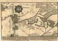
English: Relief shown by hachures on some maps and by landform drawings on some views. Individual map/view titles in German; statements of attribution in Latin. Statements of attribution differ: Ioh. Martin Will excudit Aug. Vind. -- Ioh. Martin Will. excud. Aug. Vind. -- Ioh. Mart. Will exc. Aug. Vind. Title devised by cataloger. Orientation differs. Includes index to military points of interest. Some maps also include text and local-area inset. Available also through the Library of Congress Web site as a raster image. Vault |
||
| Title | [Zehn Karten und Ansichten den Schlachtfelden des amerikanischen Unabhängigkeitskreiges in den Staaten Pennsylvanien und New York] | ||
| Shelf ID | G3821.S3 svar .W5 | ||
| Parent | https://www.loc.gov/resource/g3821sm.gas00001/ | ||
| Sheet title | [5a.] Vorstellung der Gegend des Forts Eduard ... de 17. Oct. 1777 ... [map] | ||
| Date | |||
| Source | https://www.loc.gov/item/2003630399/ | ||
| Author | Will, Johann Martin | ||
| Permission (Reusing this file) |
|
||
| Other versions |
|
||
| Location | Chestnut Hill · Pennsylvania · Chestnut Hill (Philadelphia) · Philadelphia · United States · Philadelphia Region · New York · Germantown (Philadelphia) · New York (State) · Germantown | ||
| Part of | Military Battles And Campaigns · American Memory · Catalog · Geography And Map Division · American Revolution And Its Era: Maps And Charts Of North America And The West Indies, 1750-1789 | ||
| Subject | Philadelphia Region (Pa.) · Revolution · Aerial Views · Brandywine, Battle Of, Pa. · Pennsylvania · Germantown, Battle Of, Philadelphia, Pa. · Chestnut Hill (Philadelphia) · Chestnut Hill, Battle Of, Philadelphia, Pa. · United States · Maps · Early Works To 1800 · Germantown (Philadelphia) · Burgoyne'S Invasion · Clinton'S Hudson River Expedition · New York (State) · History |

Licensing
edit
|
This is a faithful photographic reproduction of a two-dimensional, public domain work of art. The work of art itself is in the public domain for the following reason:
The official position taken by the Wikimedia Foundation is that "faithful reproductions of two-dimensional public domain works of art are public domain".
This photographic reproduction is therefore also considered to be in the public domain in the United States. In other jurisdictions, re-use of this content may be restricted; see Reuse of PD-Art photographs for details. | ||||
File history
Click on a date/time to view the file as it appeared at that time.
| Date/Time | Thumbnail | Dimensions | User | Comment | |
|---|---|---|---|---|---|
| current | 04:16, 13 July 2018 | | 3,493 × 2,489 (1.61 MB) | Fæ (talk | contribs) | LOC Maps multisheet https://www.loc.gov/item/2003630399/ sheet 9 of 10 #727 |
You cannot overwrite this file.
File usage on Commons
The following page uses this file: