Maps of Atlas sive Cosmographicae
This page was created to help categorization of the map designs that appear in (and out of) the Atlas sive Cosmographicae.
1595 & 1596: Mercator original edit
107 map sheets (every double-page containing at least one map counts as a map sheet: Scotland, Lorraine, Bourgogne and Westphalia are two sheets each; Corsica+Sardinia or Russia+Moscovia are one sheet each), in the order of the Atlas:
- Orbis Terrae Compendiosa Descriptio: Category:Mercator 1587 world map (actually by Rumold Mercator)
- Europa: Category:Maps of Europe by Gerardus Mercator (actually by Rumold, after the 1572 design by Gerardus)
- Africa: Category:Maps of Africa by Gerardus Mercator (actually by Rumold Mercator)
- Asia: Category:Maps of Asia by Gerardus Mercator (actually by Gerardus Mercator Junior)
- America sive India Nova: Category:Maps of the Americas by Gerardus Mercator (actually by Michael Mercator)
- Septentrionalium terrarum descriptio: Category:Maps of the Arctic by Gerardus Mercator
- Islandia: Category:Maps of Iceland by Gerardus Mercator (influence of Arnold Mercator unclear)
-
 Orbis Terrae (RM 1587)
 -
 Europa (Rumold 1595)
 -
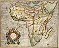 Africa (Rumold 1595)
 -
 Asia (GM Junior 1595)
 -
 America (Michael 1595)
 -
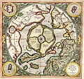 Sept. Terrarum
 -
 Islandia
_033.jpg)
_035.jpg)
_037.jpg)
_039.jpg)
_041.jpg)
_043.jpg)
_045.jpg)
- British Isles - Anglia, Scotia & Hibernia: Category:Maps of the British Isles by Gerardus Mercator
- Scotia Regnum: Category:Maps of Scotland by Gerardus Mercator
- Irlandia Regnum (= "5 Irish maps")
- Irlandia Regnum: Category:Maps of Ireland facing West by Gerardus Mercator
- ... Category:Maps of North Ireland by Gerardus Mercator
- Irlandiae Regnum: Category:Maps of South Ireland by Gerardus Mercator
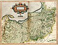
- Ultoniae orientalis pars: Category:Maps of Ulster by Gerardus Mercator
- Udrone Irlandiae in Catherlagh Baronia: Category:Maps of Idrone by Gerardus Mercator
- Anglia Regnum: Category:Maps of England by Gerardus Mercator (= "7 English maps")
- Northumbria, Cumberlandia & Dunelmensis episcopatus: Category:Maps of North England by Gerardus Mercator
- Westmorlandia, Lancastria, Cestria, Caernavan, Denbigh, Flint, Meridionidh, Montgomery, Salopia, Mania & Anglesey: Category:Maps of Westmorland and Man by Gerardus Mercator
- Cornubia, Devonia, Somersetus, Dorcestria, Wiltonia, Glocestria, Monumetha, Glamorgan, Caermarden, Penbrok, Cardigan, Radnor, Breknoke, Herefordia & Wigornia: Category:Maps of Cornwall and South Wales by Gerardus Mercator
- Eboracum, Lincolnia, Derbia, Staffordia, Notinghamia, Lecestria, Rutlandia & Norfolcia: Category:Maps of Lincolnshire and Norfolk by Gerardus Mercator
- Warwicum, Northhamtonia, Huntingdonia, Cantabrigia, Suffolcia, Oxonium, Buckinghamia, Bedfordia, Hartfordia, Essexia, Berceria, Middelsexia, Southhatonia, Surria, Cantiu & Southsexia: Category:Maps of Southeast England by Gerardus Mercator
- Anglesey / Wight Vectis olim / Garnesay / Iarsay: Category:Maps of Anglesey and Channel Islands by Gerardus Mercator
-
 Anglia, Sco., & Hib.
 -
 Scotia Regnum (1)
 -
 Scotia (2)
 -
 Scotia (3)
 -
 Irlandia Regnum (1)
 -
 Irlandia (2)
 -
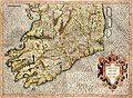 Irlandia (3)
 -
 Ultoniae
 -
 Udrone
_047.jpg)
_049.jpg)
_051.jpg)
_053.jpg)
_055.jpg)
_057.jpg)
_059.jpg)
_061.jpg)
_063.jpg)
-
 Anglia Regnum
 -
 Northumbria, etc.
 -
 Westmorlandia, etc.
 -
 Cornubia, etc.
 -
 Eboracum, etc.
 -
 Warwicum, etc.
 -
 Anglesey, etc.
_065.jpg)
_067.jpg)
_069.jpg)
_071.jpg)
_073.jpg)
_075.jpg)
_077.jpg)
- Svecia & Norvegia: Category:Maps of Scandinavia by Gerardus Mercator
- Daniae Regnu: Category:Maps of Denmark by Gerardus Mercator (= "4 Danish maps")
- Iutia Septentrionalis: Category:Maps of Nordjylland by Gerardus Mercator
- Holsatia ducatus: Category:Maps of Holstein by Gerardus Mercator
- Fionia: Category:Maps of Funen by Gerardus Mercator
- Prussia: Category:Maps of Prussia by Gerardus Mercator
- Livonia: Category:Maps of Livonia by Gerardus Mercator
- Russia: Category:Maps of Russia by Gerardus Mercator
- Lithuania: Category:Maps of Lithuania by Gerardus Mercator
- Transsylvania: Category:Maps of Transylvania by Gerardus Mercator
- Taurica Chersonesus: Category:Maps of Taurica by Gerardus Mercator (i.e. Crimea, but also Ukraine and parts of Caucasus)
-
 Svecia & Norvegia
 -
 Daniae Regnum
 -
 Iutia Sept.
 -
 Holsatia
 -
 Fionia
 -
 Prussia
 -
 Livonia
 -
 Russia
 -
 Lithuania
 -
 Transylvania
 -
 Taurica
_080.jpg)
_088.jpg)
_090.jpg)
_092.jpg)
_094.jpg)
_096.jpg)
_098.jpg)
_100.jpg)
_102.jpg)
_104.jpg)
_106.jpg)
- Gallia: Category:Maps of France by Gerardus Mercator
- Britannia & Normandia: Category:Maps of Bretagne by Gerardus Mercator
- Aquitania australis Regnu Arelatense: Category:Maps of Aquitaine by Gerardus Mercator (all of southern France)
- France Picardie Champaigne: Category:Maps of Picardie and Champagne by Gerardus Mercator (includes Isle de France)
- Bolonia & Guines: Category:Maps of Boulogne and Calais by Gerardus Mercator
- Anjou: Category:Maps of Anjou by Gerardus Mercator
- Berry ducatus: Category: Maps of Berry by Gerardus Mercator
- Poictou sive Pictauiae: Category:Maps of Poitou by Gerardus Mercator
- Lotharingia Ducatus:
- Burgundia Ducatus: Category:Maps of Bourgogne (Duchy) by Gerardus Mercator
- ...(Burgundia Comitatus): Category:Maps of Bourgogne (Comté) by Gerardus Mercator
- (Note: Artois and Alsace were annexed by France later, see below. They are however included in the "Maps of France by Gerardus Mercator" category.)
- Helvetia: Category:Maps of Switzerland by Gerardus Mercator (= "4 Swiss maps")
- ... (Zurichgow): Category:Maps of Zürichgau and Basel province by Gerardus Mercator
- Wiflisburgergow: Category:Maps of Wiflisburgergau by Gerardus Mercator
- ... (Argow): Category:Maps of Aargau by Gerardus Mercator
-
 Gallia
 -
 Britannia, etc.
 -
 Aquitania aus.
 -
 Picardie, etc.
 -
 Bolonia, etc.
 -
 Aniou
Aniou -
 Berry duc.
 -
 Poictou
 -
 Lotharingia (1)
 -
 Lotharingia (2)
 -
 Burgundia Duc.
 -
 Burgundia Com.
 -
 Helvetia
 -
 Zurichgow
 -
 Wiflisburgergow
 -
 Argow
Argow
_114.jpg)
_116.jpg)
_118.jpg)
_120.jpg)
_122.jpg)
_123.jpg)
_125.jpg)
_127.jpg)
_129.jpg)
_131.jpg)
_133.jpg)
_135.jpg)
_137.jpg)
_139.jpg)
_141.jpg)
_143.jpg)
- Belgii inferioris: Category:Maps of Benelux by Gerardus Mercator
- Flandria Comitatus: Category:Maps of Flanders by Gerardus Mercator (also includes the famous Flanders map)
- ... (Brabantia, Gulice & Cleve): Category:Maps of Brabant and Limburg by Gerardus Mercator
- Hollandt Comitatus & Utricht episcopatus: Category:Maps of Holland by Gerardus Mercator
- Zelandia Comitatus: Category:Maps of Zeeland by Gerardus Mercator
- Geldria & Transysulania: Category:Maps of Gelderland by Gerardus Mercator (Note: Trans-Ysulania = Over-IJssel)
- Artesia Comitatus: Category:Maps of Artois by Gerardus Mercator
- Hannonia, Namurcum Comitatus: Category:Maps of Hainaut and Namur by Gerardus Mercator
- Trier & Lutzenburg: Category:Maps of Trier and Luxembourg by Gerardus Mercator
- (Note: Frisia traditionally did not belong to the Spanish Netherlands. Friesland is still included in the "Maps of Benelux by Gerardus Mercator" category.)
-
 Belgii inf.
 -
 Flandria
 -
 Brabantia
 -
 Hollandt
 -
 Zelandia
 -
 Geldria
 -
 Artesia
 -
 Hannonia
 -
 Trier
Trier
_151.jpg)
_153.jpg)
_155.jpg)
_157.jpg)
_159.jpg)
_161.jpg)
_163.jpg)
_165.jpg)
_167.jpg)
- Germania: Category:Maps of Germany by Gerardus Mercator
- Frisia occidentalis: Category:Maps of Friesland by Gerardus Mercator
- Emden et Oldenborch Comitatus: Category:Maps of Emden and Oldenburg by Gerardus Mercator
- Westfalia cum Dioecesi Bremensi: Category:Maps of Westphalia and Bremen by Gerardus Mercator
- ...: Category:Maps of Westphalia by Gerardus Mercator
- Berghe Ducatus, Marck Comitatus et Coloniensis Dioecesis: Category:Maps of Berg and Mark by Gerardus Mercator
- Waldeck Comitatus: Category:Maps of Waldeck by Gerardus Mercator
- Palatinatus Rheni: Category:Maps of Rhenian Palatinate by Gerardus Mercator
- Wirtenberg Ducatus: Category:Maps of Württemberg by Gerardus Mercator
- Alsatia inferior: Category:Maps of Lower Alsace by Gerardus Mercator
- Alsatia superior cum Suntgoia & Brisgoia: Category:Maps of Alsace, Breisgau and Sundgau by Gerardus Mercator
- Saxonia inferior & Mecklenborg Ducatus: Category:Maps of Lower Saxony by Gerardus Mercator
- Braunswyck & Meydburg: Category:Maps of Braunschweig and Magdeburg by Gerardus Mercator
- Hassia landtgraviatus: Category:Maps of Hesse by Gerardus Mercator
- Thuringia: Category:Maps of Thuringia by Gerardus Mercator
- Franckenlandt Francia orientalis: Category:Maps of Franconia by Gerardus Mercator
- Bavaria ducatus: Category:Maps of Bavaria by Gerardus Mercator
- Palatinatus Bavariae: Category:Maps of Bavarian Palatinate by Gerardus Mercator
- Saxoniae superioris Lusatiae Misniaeque: Category:Maps of Saxony by Gerardus Mercator
- Marca Brandenburgensis & Pomerania: Category:Maps of Brandenburg and Pomerania by Gerardus Mercator
- Bohemia: Category:Maps of Bohemia by Gerardus Mercator
- Moravia: Category:Maps of Moravia by Gerardus Mercator
- Austria archiducatus: Category:Maps of Austria by Gerardus Mercator
- Saltzburg archiepiscopatus cum ducatu Carinthiae: Category:Maps of Salzburg and Carinthia by Gerardus Mercator
- (Note: Limburg, Holstein, Prussia, Styria and Trier were at the time not part of Germany or the Holy Roman Empire, but are still included in the "Maps of Germany by Gerardus Mercatur" category.)
- Polonia & Silesia: Category:Maps of Poland and Silesia by Gerardus Mercator
- Hungaria: Category:Maps of Hungary by Gerardus Mercator
-
 Germania
 -
 Frisia
 -
 Emden, etc.
 -
 Westfalia (1)
 -
 Westfalia (2)
 -
 Berghe, etc.
 -
 Waldeck
 -
 Palatinatus R.
 -
 Wirtenberg
 -
 Alsatia inf.
 -
 Alsatia sup.
 -
 Saxonia inf.
 -
 Braunswyck
 -
 Hassia
 -
 Thuringia
 -
 Franckenlandt
 -
 Bavaria
 -
 Palatinatus B.
 -
 Saxoniae sup.
 -
 Marca Brandenb.
 -
 Bohemia
 -
 Moravia
 -
 Austria
 -
 Saltzburg
 -
 Polonia
 -
 Hungaria
_175.jpg)
_177.jpg)
_179.jpg)
_181.jpg)
_183.jpg)
_185.jpg)
_187.jpg)
_189.jpg)
_191.jpg)
_193.jpg)
_195.jpg)
_197.jpg)
_199.jpg)
_201.jpg)
_203.jpg)
_205.jpg)
_207.jpg)
_209.jpg)
_211.jpg)
_213.jpg)
_215.jpg)
_217.jpg)
_219.jpg)
_221.jpg)
_223.jpg)
_225.jpg)
- Italia: Category:Maps of Italy by Gerardus Mercator
- Lombardiae Alpestris pars occidentalis cum Valesia: Category:Maps of Lombardy by Gerardus Mercator
- Tarvisina Marchia & Tirolis comitatus: Category:Maps of Tyrol and Venice by Gerardus Mercator
- Pedemontana regio cum Genuensium territorio & Montisferrati Marchionatu: Category:Maps of Piedmont and Genoa by Gerardus Mercator
- Romandiola cum Parmensi ducatu: Category:Maps of Emilia-Romagna by Gerardus Mercator
- Brescia episcopatus Mediolanu ducatus: Category:Maps of Brescia and Milan by Gerardus Mercator
- Veronae vicentiae & Patavii ditiones: Category:Maps of Verona and Padua by Gerardus Mercator
- Forum Iulium, Karstia, Carniola, Histria & Windorum Marchia: Category:Maps of Karstia and Carniola by Gerardus Mercator
- Tuscia: Category:Maps of Tuscany by Gerardus Mercator
- Marchia Anconitana cum Spoletano Ducatu: Category:Maps of Marche by Gerardus Mercator
- Latium nunc Campagna di Roma: Category:Maps of Lazio by Gerardus Mercator
- Abruzzo & Terra di Lavoro: Category:Maps of Abruzzo by Gerardus Mercator
- Puglia Piana, Terra di Barri, Terra di Ortranto, Calabria & Basilicata: Category:Maps of Apulia by Gerardus Mercator
- Siciliae Regnum: Category:Maps of Sicily by Gerardus Mercator
- Stiria: Category:Maps of Styria by Gerardus Mercator
- Sclavonia, Croatia, Bosnia cum Dalmatiae parte: Category:Maps of Slavonia by Gerardus Mercator
- Walachia, Servia, Bulgaria, Romania: Category:Maps of Wallachia by Gerardus Mercator
- Graecia: Category:Maps of Greece by Gerardus Mercator
- Macedonia, Epirus & Achaia: Category:Maps of Macedonia by Gerardus Mercator
- Morea olim Peleponnesus: Category:Maps of the Peloponnese by Gerardus Mercator
- Candia cum Insulis aliquot circa Graeciam: Category:Maps of Candia by Ortelius and Mercator
-
 Italia
 -
 Lombardiae
 -
 Tarvisina
 -
 Pedemontana
 -
 Romandiola
 -
 Brescia
 -
 Veronae
 -
 Forum Iulium
 -
 Tuscia
 -
 Marchia Anc.
 -
 Latium
 -
 Abruzzo
 -
 Puglia Piana
 -
 Corsica, etc.
 -
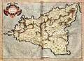 Siciliae
 -
 Stiria
 -
 Sclavonia
 -
 Walachia
 -
 Graecia
 -
 Macedonia
 -
 Morea, etc.
 -
 Candia , etc.
_233.jpg)
_235.jpg)
_237.jpg)
_239.jpg)
_241.jpg)
_243.jpg)
_245.jpg)
_247.jpg)
_249.jpg)
_251.jpg)
_253.jpg)
_255.jpg)
_257.jpg)
_259.jpg)
_261.jpg)
_263.jpg)
_265.jpg)
_267.jpg)
_269.jpg)
_271.jpg)
_273.jpg)
_275.jpg)
Note that the original Mercator Atlas had no further maps on Spain, or detailed maps of Africa, Asia and the Americas.
1602-1630: Mercator-Hondius edit
1607 edition: edit
Included all map sheets of the original Mercator - except Rumold-Africa, Gerhard-Junior-Asia and Michael-Americas. Jodocus Hondius then added 39 new maps (only those are detailed below): several by other map-makers (categorized under their original names), but most by him, although lifting the basic map designs mostly from Abraham Ortelius' maps (these latter ones are categorized as "Mercator-Hondius"). In order:
- Mercator-original maps of World and Europe by Rumold (see above)
- NEW: Europae nova descriptio Category:Maps of Europe by Mercator-Hondius (as a second Europe map, differing from the first)
- Mercator-original map designs (see above): Arctic, Iceland, British Isles, 5 Irish maps, 3 Scottish maps...
- NEW Cambriae typus: Category:Maps of Wales by Humphrey Llwyd included as #3 into the 7 English maps (see above) (=> 8 English maps)
- Mercator-original map designs (see above): Scandinavia, 4 Danish maps, Livonia, Prussia, Russia, Lithuania, Transylvania, Taurica.
- NEW: Jodocus Hondius designs - Hispaniae Nova descriptio: Category:Maps of the Iberian Peninsula by Mercator-Hondius (=> 7 Spanish maps)
- NEW: Portugalliae que olim Lusitaniae: Category:Maps of Portugal by Fernando Álvares Seco
- NEW: Legionis, Biscaiae & Guipiscoae typus: Category:Maps of Biscay and Gipuzkoa by Mercator-Hondius
- NEW: Castiliae veteris: Category:Maps of Castile by Mercator-Hondius
- NEW: Andaluziae Category:Maps of Andalusia by Mercator-Hondius
- NEW: Regni Valentiae: Category:Maps of Valencia by Mercator-Hondius
- NEW: Arragonia & Catalonia: Category:Maps of Aragon and Catalonia by Mercator-Hondius
- Mercator-original map designs (see above): all France maps, and:
- NEW: Totius Lemovici: Category:Maps of Limousin by Jean Fayen included as #3 (between Bretagne & Aquitaine)
- NEW: L'Isle de France Parisiesis: Category:Maps of Île-de-France by François de La Guillotière included as #5 (between Picardie and Boulogne)
- Mercator-original map designs (see above): 4 Swiss maps, and:
- NEW: Chorographica Tabula Lacus Lemanni: Category:Maps of Lake Geneva by Jacques Goulart included as #4 (between Wiflisburgergau and Aargau (=> 5 Swiss maps)
- Mercator-original map designs (see above): all Benelux maps, and:
- NEW: Habes hic ... Flandriae: Category:Maps of East Flanders by Pieter van der Keere as #3 (between Flanders and Brabant)
- Mercator-original map designs (see above): all Germany maps, and:
- NEW: Murs comitatum: Category:Maps of Moers by Johannes Mercator as #7 (after Berg)
- NEW: Leodiensis dioecesis typus: Category:Maps of Liège by Baptista van Doetecum as #8 (before Waldeck)
- NEW: Rugiae: Category:Maps of Rügen by Eilhard Lubinus as #23 (between Brandenburg and Bohemia)
- Mercator-original map designs (see above): Poland, Hungary, all Italy maps, Slavonia, Wallachia, all Greece maps
- NEW: Africae Tabula: Category:Maps of Africa by Mercator-Hondius
- NEW: Barbaria: Category:Maps of Barbary Coast by Mercator-Hondius
- NEW: Fessae & Marocchi Regna: Category:Maps of Morocco by Mercator-Hondius
- NEW: Abissinorum sive pretiosi Joannis imperium: Category:Maps of Abyssinia by Mercator-Hondius
- NEW: Guineae nova descriptio: Category:Maps of Guinea by Mercator-Hondius
- NEW: Asiae nova descriptio: Category:Maps of Asia by Mercator-Hondius
- NEW: Turcici Imperio imago: Category:Maps of the Ottoman Empire by Mercator-Hondius
- NEW: Terra Sancta qu(a)e in sacris Terra Promissionis olim Palestina: Category:Maps of the Holy Land by Mercator-Hondius
- NEW: Natoliae sive Asia Minor: Category:Maps of Asia Minor by Mercator-Hondius
- NEW: Cyprus Insula: Category:Maps of Cyprus by Mercator-Hondius
- NEW: Persici vel Sophorum regni typus: Category:Maps of Persia by Mercator-Hondius
- NEW: Tartaria: Category:Maps of Tartary by Mercator-Hondius
- NEW: China: Category:Maps of China by Mercator-Hondius
- NEW: India Orientalis: Category:Maps of South Asia by Mercator-Hondius
- NEW: Insulae Indiae Orientalis: Category:Maps of the Malay Archipelago by Mercator-Hondius
- NEW: Iaponia: Category:Maps of Japan by Mercator-Hondius
- NEW: Insula Ceilan: Category:Maps of Ceylon by Petrus Plancius
- NEW: America: Category:Maps of the Americas by Mercator-Hondius
- NEW: Hispaniae Novae nova descriptio: Category:Maps of Mexico by Mercator-Hondius
- NEW: Virginiae & Floridae: Category:Maps of Virginia by Mercator-Hondius (Florida is just a border region in the map)
- NEW: Cuba Insula / Hispaniola Insula: Category:Maps of the Caribbean by Mercator-Hondius
- NEW: America Meridionalis: Category:Maps of South America by Mercator-Hondius
- NEW: Patagonia / Strait of Magellan Category:Maps of the Magellan Straits by Lambert Cornelis
later editions: edit
- Additions to Spain in the 1611 and/or 1613 editions:
- Galaecia regnum: Category:Maps of Galicia by Mercator-Hondius
- Cataloniae principatus descriptio nova: Category:Maps of Catalonia by Mercator-Hondius
- Additions to France in the 1609, 1611 and 1613 editions:
- Provinciae regionus Galliae: Category:Maps of Provence by Pierre-Jean de Bompar
- Limburgensis ducatos: Category:Maps of Limburg by Aegidius Martini
- Additions to Non-European regions in later editions:
- Paradisus: Category:Maps of Paradise by Mercator-Hondius
- Egypt: Ptolemy's III-B Africa Map, in Atlas Minor 1609.
- History maps in Atlas Minor (Exodus, Alexander, Roman Empire, Paul's journeys)
Atlas Minor (the "Pocket Atlas") edit
All map designs were heavily generalized, but are recognizable as the Mercator-Hondius maps:
- Maps of Europe, Africa and Asia by Jodocus Hondius
- Gerhard Mercator's map designs: Arctic, Iceland, British Isles, 5 Irish maps, 3 Scottish maps, 7 English maps, Scandinavia, 4 Danish maps, Livonia, Prussia, [Moscovia (the inset map of G.M.'s Russia)], Russia (w/o inset), Lithuania, Transylvania, Taurica.
- Jodocus Hondius designs: 7 Spanish maps, with one extra "Gipuzkoa Coregentia".
1633-1660s: Mercator-Hondius-Jansonius edit
- Addition to Scotland since at least 1630:
- Lothian and Linlitquo: Category:Maps of Lothian by Timothy Pont

_b_005.jpg)
_001.jpg)
_005.jpg)
_008.jpg)
_009.jpg)
_010.jpg)
_015.jpg)
_020.jpg)
_025.jpg)
_028.jpg)
_029.jpg)
_032.jpg)
_034.jpg)
_036.jpg)
_038.jpg)
_040.jpg)
_042.jpg)
_044.jpg)
_046.jpg)
_048.jpg)
_054.jpg)
_064.jpg)
_079.jpg)
_081.jpg)
_083.jpg)
_085.jpg)
_095.jpg)
_097.jpg)
_099.jpg)
_101.jpg)
_103.jpg)
_105.jpg)
_107.jpg)
_113.jpg)
_115.jpg)
_117.jpg)
_119.jpg)
_121.jpg)
_124.jpg)
_126.jpg)
_128.jpg)
_132.jpg)
_136.jpg)
_138.jpg)
_140.jpg)
_142.jpg)
_144.jpg)
_146.jpg)
_150.jpg)
_152.jpg)
_154.jpg)
_156.jpg)
_158.jpg)
_160.jpg)
_162.jpg)
_164.jpg)
_166.jpg)
_168.jpg)
_170.jpg)
_174.jpg)
_176.jpg)
_178.jpg)
_180.jpg)
_186.jpg)
_188.jpg)
_190.jpg)
_192.jpg)
_194.jpg)
_196.jpg)
_198.jpg)
_200.jpg)
_202.jpg)
_204.jpg)
_206.jpg)
_208.jpg)
_210.jpg)
_212.jpg)
_214.jpg)
_216.jpg)
_218.jpg)
_220.jpg)
_222.jpg)
_224.jpg)
_226.jpg)
_230.jpg)
_232.jpg)
_234.jpg)
_242.jpg)
_244.jpg)
_246.jpg)
_248.jpg)
_250.jpg)
_252.jpg)
_254.jpg)
_256.jpg)
_258.jpg)
_260.jpg)
_262.jpg)
_264.jpg)
_266.jpg)
_268.jpg)
_270.jpg)
_272.jpg)
_274.jpg)
_276.jpg)
_279.jpg)
_284.jpg)