Category:1860s maps of the Netherlands
Countries of Europe: Albania · Armenia‡ · Austria · Azerbaijan‡ · Belarus · Belgium · Bosnia and Herzegovina · Bulgaria · Croatia · Cyprus‡ · Czech Republic · Denmark · Estonia · Finland · France‡ · Georgia‡ · Germany · Greece · Hungary · Republic of Ireland · Italy · Latvia · Lithuania · Moldova · Montenegro · Netherlands‡ · Norway · Poland · Portugal‡ · Romania · Russia‡ · Serbia · Slovenia · Spain‡ · Sweden · Switzerland · Turkey‡ · Ukraine · United Kingdom
Limited recognition: Abkhazia‡
‡: partly located in Europe
Limited recognition: Abkhazia‡
‡: partly located in Europe
Provinces of the Netherlands: North Holland · South Holland ·
Subcategories
This category has the following 2 subcategories, out of 2 total.
N
- 1860s maps of North Holland (186 F)
S
- 1860s maps of South Holland (238 F)
Media in category "1860s maps of the Netherlands"
The following 14 files are in this category, out of 14 total.
-
-
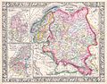
 Map of Holland-Belgien-Luxemburg in 1844 - Radefeld - Meyers Handatlas 1860.jpg 7,575 × 9,850; 15.71 MB
-

-

-

-

-

-

-
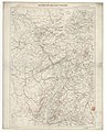 Le Rhin et les pays voisins - par A. Vuillemin... - btv1b84684900.jpg 8,575 × 10,720; 14.44 MB
-
 1866 Johnson Map of Holland and Belgium - Geographicus - HollandBelgium-johnson-1865.jpg 3,233 × 4,000; 4.94 MB
-

-

-
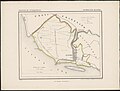 Provincie Overijssel gemeente Kuinre 1867.jpg 3,153 × 2,380; 1.93 MB
-
 Holland and Belgium (8250972876).jpg 1,659 × 2,000; 2.77 MB


_Het_koningrijk_der_Nederlanden,_by_A._Braakensiek,_from_the_Digital_Commonwealth_-_commonwealth_0z709588c.jpg)
%27_(11062793314).jpg)
%27_(11062521776).jpg)


%27_(11242693555).jpg)

.jpg)