Category:1940s maps of Iceland
Countries of Europe: Austria · Belarus · Belgium · Bosnia and Herzegovina · Bulgaria · Denmark · Finland · France‡ · Germany · Greece · Hungary · Iceland · Republic of Ireland · Italy · Lithuania · Luxembourg · Netherlands‡ · Norway · Poland · Portugal‡ · Romania · Russia‡ · Spain‡ · Sweden · Switzerland · Turkey‡ · Ukraine · United Kingdom
‡: partly located in Europe
‡: partly located in Europe
Media in category "1940s maps of Iceland"
The following 8 files are in this category, out of 8 total.
-
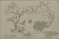 UK War Office Road Map Iceland Published 1942.png 540 × 357; 297 KB
-
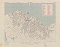 1943 map of Reykjavik by the U.S. Army Map Service.jpg 8,934 × 7,030; 9.47 MB
-
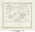
 Iceland - DPLA - d7064f1135217d0eaa84f0119f652869.jpg 4,384 × 3,352; 1.48 MB
-
 Iceland - DPLA - 31d7a49bdd0dbb2dd7140f21587afebe.jpg 3,559 × 3,267; 1.39 MB
-
 Iceland - DPLA - d2f2feee87e4080c76f8bef294bcde10.jpg 12,058 × 7,875; 8.51 MB
-
 Iceland - DPLA - dd6f57713aa8eea51ca5b4412cc20f0c.jpg 11,901 × 7,871; 9.68 MB
-
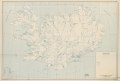
 Iceland. 11-49. LOC 74694365.jpg 13,452 × 9,101; 9.76 MB
-
 Iceland. 11-49. LOC 74694365.tif 13,452 × 9,101; 350.27 MB


