Commons:Wiki Loves Monuments in Switzerland/Thurgau/A-E
Aadorf


Affeltrangen
| Location | Upload | Photo | Object | Cat. | Coordinates | KGS-Nr | |
|---|---|---|---|---|---|---|---|
| Affeltrangen | 
|
Altes Schulhaus Märwil | B | 47°31′59″N 9°04′21″E / 47.532963°N 9.072541°E | 10903 | ||
| Affeltrangen | 
|
Katholische Kapelle St. Jakobus | B | 47°32′44″N 9°02′03″E / 47.545616°N 9.034108°E | 13588 | ||
| Affeltrangen | 
|
Reformierte Kirche | B | 47°31′57″N 9°04′28″E / 47.532486°N 9.074492°E | 5110 | ||
| Affeltrangen | 
|
Reformierte Kirche | B | 47°31′33″N 9°01′48″E / 47.525937°N 9.029865°E | 13587 | ||
| Affeltrangen | 
|
Wohnhaus Bollsteg / Baronenhaus | B | 47°31′59″N 9°01′38″E / 47.533009°N 9.027181°E | 10902 | ||
Altnau
| Location | Upload | Photo | Object | Cat. | Coordinates | KGS-Nr | |
|---|---|---|---|---|---|---|---|
| Altnau | 
|
Ehemaliges Arzthaus | B | 47°36′29″N 9°15′29″E / 47.607918°N 9.257951°E | 13590 | ||
| Altnau | 
|
Katholisches Kirchgemeindehaus / Ehemaliges Mesmerhaus | B | 47°36′25″N 9°15′28″E / 47.607065°N 9.257842°E | 13591 | ||
| Altnau | 
|
Reformierte Kirche | B | 47°36′28″N 9°15′27″E / 47.607915°N 9.257525°E | 4908 | ||
| Altnau | 
|
Reformiertes Pfarrhaus | B | 47°36′30″N 9°15′28″E / 47.608244°N 9.257802°E | 13589 | ||
Amlikon-Bissegg
| Location | Upload | Photo | Object | Cat. | Coordinates | KGS-Nr | |
|---|---|---|---|---|---|---|---|
| Amlikon-Bissegg | 
|
Bauernhaus | B | 47°34′14″N 9°03′28″E / 47.570485°N 9.057717°E | 13592 | ||
| Amlikon-Bissegg | 
|
Bauernhaus | B | 47°34′13″N 9°03′27″E / 47.570297°N 9.057632°E | 13593 | ||
| Amlikon-Bissegg | _034.JPG)
|
Doppelwohnhaus (Nordteil) | B | 47°33′42″N 9°02′41″E / 47.561725°N 9.044639°E | 13594 | ||
| Amlikon-Bissegg | 
|
Gedeckte Holzbrücke über die Thur | B | 47°34′45″N 9°01′28″E / 47.579238°N 9.024536°E | 4998 | ||
| Amlikon-Bissegg | 
|
Katholische Kapelle Maria am hohen Wege | B | 47°34′03″N 9°01′43″E / 47.567561°N 9.028493°E | 10905 | ||
| Amlikon-Bissegg | 
|
Restaurant Biene | B | 47°33′01″N 9°02′19″E / 47.550296°N 9.0385°E | 10904 | ||
| Amlikon-Bissegg | 
|
Wohnhaus | B | 47°34′07″N 9°00′42″E / 47.568643°N 9.011792°E | 13595 | ||
Amriswil


Arbon


_050.JPG)


Basadingen-Schlattingen
| Location | Upload | Photo | Object | Cat. | Coordinates | KGS-Nr | |
|---|---|---|---|---|---|---|---|
| Basadingen-Schlattingen | 
|
Katholisches Pfarrhaus | B | 47°40′19″N 8°44′53″E / 47.672023°N 8.748183°E | 13621 | ||
| Basadingen-Schlattingen | 
|
Paritätische Kirche St. Martin | B | 47°40′19″N 8°44′56″E / 47.671934°N 8.748847°E | 4927 | ||
| Basadingen-Schlattingen | 
|
Reformierte Kirche St. Georg mit Bautengruppe Kloster | B | 47°39′45″N 8°46′05″E / 47.662417°N 8.767984°E | 5152 | ||
| Basadingen-Schlattingen | 
|
Schulhaus Im Zelgli | B | 47°39′57″N 8°46′09″E / 47.665865°N 8.769216°E | 13622 | ||
Berg
| Location | Upload | Photo | Object | Cat. | Coordinates | KGS-Nr | |
|---|---|---|---|---|---|---|---|
| Berg | 
|
Bauernhaus | B | 47°35′43″N 9°10′54″E / 47.595155°N 9.181576°E | 10924 | ||
| Berg | 
|
Bauernhaus | B | 47°34′36″N 9°09′55″E / 47.576616°N 9.165254°E | 13625 | ||
| Berg | 
|
Bauernhaus | B | 47°33′58″N 9°09′21″E / 47.566049°N 9.155965°E | 13627 | ||
| Berg | 
|
Ehemaliges Gasthaus Zum Adler | B | 47°34′37″N 9°09′55″E / 47.576904°N 9.165276°E | 13624 | ||
| Berg | 
|
Katholische Kirche St. Mauritius | B | 47°34′41″N 9°09′55″E / 47.578117°N 9.165369°E | 13626 | ||
| Berg | 
|
Kehlhof, Weiler mit Bahnhof | B | 47°34′24″N 9°09′59″E / 47.573404°N 9.166478°E | 4929 | ||
| Berg | 
|
Primarschulhaus | B | 47°34′41″N 9°10′01″E / 47.57795°N 9.166866°E | 10925 | ||
| Berg | 
|
Reformierte Kirche | B | 47°34′36″N 9°09′50″E / 47.576618°N 9.163937°E | 4930 | ||
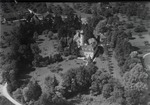
| Berg | 
|
Schloss Berg mit Kapelle | B | 47°34′43″N 9°09′38″E / 47.578627°N 9.160679°E | 4931 | ||
| Berg | 
|
Wohnhaus | B | 47°34′40″N 9°10′48″E / 47.577862°N 9.180011°E | 13623 | ||
Berlingen
| Location | Upload | Photo | Object | Cat. | Coordinates | KGS-Nr | |
|---|---|---|---|---|---|---|---|
| Berlingen | 
|
Adolf Dietrich-Haus | B | 47°40′26″N 9°00′57″E / 47.673799°N 9.015737°E | 13628 | ||
| Berlingen | 
|
Grosses Haus / Kehlhof | B | 47°40′24″N 9°00′55″E / 47.673293°N 9.015309°E | 4933 | ||
| Berlingen | 
|
Rathaus / Haus Schiff | B | 47°40′29″N 9°01′03″E / 47.674702°N 9.017508°E | 13629 | ||
| Berlingen | 
|
Reformierte Kirche | B | 47°40′28″N 9°00′58″E / 47.674359°N 9.016246°E | 4932 | ||
Bettwiesen
| Location | Upload | Photo | Object | Cat. | Coordinates | KGS-Nr | |
|---|---|---|---|---|---|---|---|
| Bettwiesen | 
|
Schloss | A | 47°29′46″N 9°01′47″E / 47.496003°N 9.029607°E | 4934 | ||
| Bettwiesen | 
|
Katholische Kirche St. Urban | B | 47°29′39″N 9°01′36″E / 47.494147°N 9.026578°E | 13630 | ||
Bichelsee-Balterswil
| Location | Upload | Photo | Object | Cat. | Coordinates | KGS-Nr | |
|---|---|---|---|---|---|---|---|
| Bichelsee-Balterswil | 
|
Katholische Kirche St. Blasius | B | 47°26′54″N 8°55′21″E / 47.448326°N 8.922555°E | 13631 | ||
| Bichelsee-Balterswil | 
|
Katholisches Pfarrhaus | B | 47°26′53″N 8°55′21″E / 47.447921°N 8.922583°E | 10926 | ||
| Bichelsee-Balterswil | 
|
Evangelische Kirche | B | 47°27′00″N 8°55′28″E / 47.449902°N 8.924575°E | 13632 | ||
Birwinken
| Location | Upload | Photo | Object | Cat. | Coordinates | KGS-Nr | |
|---|---|---|---|---|---|---|---|
| Birwinken | 
|
Bauernhaus | B | 47°34′58″N 9°11′47″E / 47.582813°N 9.196487°E | 13634 | ||
| Birwinken | _161.JPG)
|
Reformierte Kirche | B | 47°34′57″N 9°11′50″E / 47.582458°N 9.197327°E | 13633 | ||
| Birwinken | 
|
Reformierte Kirche | B | 47°33′57″N 9°12′57″E / 47.565703°N 9.215925°E | 4935 | ||
Bischofszell


.jpg)
.jpg)
_Linde_Bischofszell.jpg)

.jpg)

.jpg)


.jpg)

.jpg)
.jpg)
.jpg)
.jpg)
.jpg)
.jpg)
.jpg)
.jpg)
.jpg)


Braunau
| Location | Upload | Photo | Object | Cat. | Coordinates | KGS-Nr | |
|---|---|---|---|---|---|---|---|
| Braunau |
|
Ehemaliges Gasthaus Kreuz | B | 47°30′08″N 9°04′21″E / 47.502297°N 9.072488°E | 13655 | ||
| Braunau | _katolika_kapelo_265.JPG)
|
Katholische Kapelle St. Michael | B | 47°30′09″N 9°04′26″E / 47.502584°N 9.073785°E | 4948 | ||
| Braunau | 
|
Reformierte Kirche | B | 47°30′14″N 9°04′16″E / 47.503754°N 9.071192°E | 13656 | ||
| Braunau |
|
Wohnhaus | B | 47°30′10″N 9°04′15″E / 47.502888°N 9.070754°E | 13657 | ||
Bürglen
| Location | Upload | Photo | Object | Cat. | Coordinates | KGS-Nr | |
|---|---|---|---|---|---|---|---|
| Bürglen | _194.JPG)
|
Schloss Bürglen | B | 47°32′51″N 9°09′14″E / 47.5476°N 9.15381°E | 4952 | ||
| Bürglen | _180.JPG)
|
Bürglen, Altstadt, Schloss | B | 47°32′52″N 9°09′13″E / 47.547776°N 9.153687°E | 9677 | ||
| Bürglen | 
|
Reformierte Kirche | B | 47°32′50″N 9°09′15″E / 47.547217594°N 9.154083763°E | 13658 | ||
| Bürglen | _189.JPG)
|
Bürglen | ISOS | 47°32′59″N 9°08′59″E / 47.549722222°N 9.149722222°E | |||
Bussnang
| Location | Upload | Photo | Object | Cat. | Coordinates | KGS-Nr | |
|---|---|---|---|---|---|---|---|
| Bussnang | 
|
Evangelische Kirche Bussnang | B | 47°33′28″N 9°04′55″E / 47.5578°N 9.08197°E | 10940 | ||
| Bussnang | 
|
Bauernhaus | B | 47°32′51″N 9°03′01″E / 47.54738°N 9.050291°E | 13660 | ||
| Bussnang | 
|
Hängesteg über die Thur / Ganggelisteg | B | 47°33′32″N 9°05′18″E / 47.558909°N 9.088223°E | 4954 | ||
| Bussnang | _116.JPG)
|
Katholische Kirche St. Joseph | B | 47°33′30″N 9°04′52″E / 47.558392°N 9.080977°E | 13659 | ||
| Bussnang | _146_(cropped).JPG)
|
Katholische Kirche St. Peter und Verena | B | 47°32′09″N 9°08′10″E / 47.535836°N 9.136112°E | 5139 | ||
| Bussnang | 
|
Oppikon-Eppenstein, Burgstock, ehemalige Burg Eppenstein | B | 47°32′56″N 9°02′48″E / 47.548861°N 9.046628°E | 13881 | ||
| Bussnang | 
|
Restaurant Traube | B | 47°32′09″N 9°08′08″E / 47.535843°N 9.135648°E | 13661 | ||
| Bussnang |
|
Wertbühl | ISOS | 47°32′01″N 9°08′27″E / 47.5337°N 9.1409°E | |||
Diessenhofen
| Location | Upload | Photo | Object | Cat. | Coordinates | KGS-Nr | |
|---|---|---|---|---|---|---|---|
| Diessenhofen | 
|
Kloster St. Katharinental | A+ISOS | 47°41′29″N 8°44′13″E / 47.69145°N 8.737047222°E | 5213 | ||
| Diessenhofen | 
|
Sammlung Goldener Leuen | A | 47°41′22″N 8°45′00″E / 47.68939°N 8.74997°E | 8455 | ||
| Diessenhofen |
|
Bürgerarchiv im Rathaus | A | 47°41′24″N 8°45′08″E / 47.689887°N 8.752101°E | 11770 | ||
| Diessenhofen | 
|
Rheinbrücke Diessenhofen–Gailingen | A | 47°41′26″N 8°45′02″E / 47.6905°N 8.75051°E | 4955 | ||
| Diessenhofen | 
|
Burg Unterhof | A | 47°41′24″N 8°44′52″E / 47.690053°N 8.747736°E | 4961 | ||
| Diessenhofen | 
|
Haus zum Goldenen Löwen | A | 47°41′22″N 8°45′00″E / 47.689336°N 8.749943°E | 4956 | ||
| Diessenhofen | 
|
Kornscheune des ehemaligen Dominikanerinnenklosters St. Katharinental, Willisdorf, Kloster | A | 47°41′28″N 8°44′01″E / 47.691013°N 8.733493°E | 9055 | ||
| Diessenhofen | 
|
Stadtbefestigung (Stadtmauer, Hänkiturm, Siegelturm, Thüerenturm) | A | 47°41′21″N 8°45′07″E / 47.689233°N 8.751819°E | 10235 | ||
| Diessenhofen |
|
Altes Schulhaus / Ehemaliges Zunfthaus zum Grimmen Löwen | B | 47°41′20″N 8°45′00″E / 47.68884°N 8.749997°E | 10948 | ||
| Diessenhofen | 
|
Bruder Klaus Kirche mit freistehendem Kirchturm | B | 47°41′11″N 8°45′09″E / 47.686311°N 8.752532°E | 13668 | ||
| Diessenhofen | 
|
Ehemalige Badstube, Gerberei | B | 47°41′25″N 8°45′01″E / 47.690384°N 8.750275°E | 13666 | ||
| Diessenhofen |
|
Haus Zum Wildenmann / Zur Goldenen Sau | B | 47°41′22″N 8°45′02″E / 47.689554°N 8.750468°E | 13663 | ||
| Diessenhofen |
|
Katholische Kapelle St. Sebastian | B | 47°40′51″N 8°44′04″E / 47.680947°N 8.734432°E | 5214 | ||
| Diessenhofen | 
|
Klosterhaus | B | 47°41′23″N 8°44′56″E / 47.689697°N 8.748993°E | 10946 | ||
| Diessenhofen | 
|
Klösterli | B | 47°41′22″N 8°45′01″E / 47.689306°N 8.750155°E | 10942 | ||
| Diessenhofen |
|
Mühle Bachmann | B | 47°40′47″N 8°44′18″E / 47.679822°N 8.738467°E | 13670 | ||
| Diessenhofen |
|
Museum Kunst und Wissen, Diessenhofen, mit Sammlung der Roesch-Stiftung | B | 47°41′24″N 8°45′11″E / 47.689864921°N 8.753095084°E | 16142 | ||
| Diessenhofen |
|
Museum Rösch | B | 47°41′24″N 8°45′11″E / 47.68992°N 8.753115°E | 13889 | ||
| Diessenhofen | 
|
Petershauser Amtshaus | B | 47°41′24″N 8°45′11″E / 47.689911°N 8.753101°E | 4957 | ||
| Diessenhofen | 
|
Rathaus | B | 47°41′24″N 8°45′08″E / 47.689887°N 8.752101°E | 4958 | ||
| Diessenhofen | Reformierte Kirche St. Dionys | Reformierte Kirche St. Dionys | B | 47°41′24″N 8°44′55″E / 47.689981°N 8.74856°E | 4967 | ||
| Diessenhofen | 
|
Scheune Flum-Schüür | B | 47°41′23″N 8°44′54″E / 47.689623°N 8.748378°E | 13669 | ||
| Diessenhofen | 
|
Villa Rosenheim | B | 47°41′15″N 8°45′14″E / 47.687554°N 8.753975°E | 13667 | ||
| Diessenhofen |
|
Volkskundliche Sammlung im Kornhaus des ehem. Dominikanerinnenkloster St. Katharinental | B | 47°41′30″N 8°44′11″E / 47.691556°N 8.736397°E | 11611 | ||
| Diessenhofen | 
|
Vorderes Amtshaus / Konstanzer Amtshaus / Toggenburgerhaus | B | 47°41′25″N 8°45′05″E / 47.6902°N 8.751416°E | 10949 | ||
| Diessenhofen | 
|
Wohnhaus Lindenhof | B | 47°41′17″N 8°45′16″E / 47.68798°N 8.754505°E | 13662 | ||
| Diessenhofen | [[File:|150x150px|Wohnhaus Neuhaus]] | Wohnhaus Neuhaus | B | 47°41′22″N 8°44′56″E / 47.689537°N 8.748869°E | 13664 | ||
| Diessenhofen | 
|
Wohnhaus Oberhof | B | 47°41′24″N 8°45′06″E / 47.689945°N 8.751743°E | 4966 | ||
| Diessenhofen |
|
Wohnhaus Rebstock | B | 47°41′21″N 8°45′02″E / 47.68922°N 8.75062°E | 13665 | ||
| Diessenhofen | 
|
Wohnhaus Zum Pelikan | B | 47°41′22″N 8°45′01″E / 47.689313°N 8.750316°E | 10944 | ||
| Diessenhofen | 
|
Wohnhaus Zum Schneggen | B | 47°41′24″N 8°44′57″E / 47.690055°N 8.749188°E | 10947 | ||
| Diessenhofen | 
|
Wohnhaus Zum Wilden Mann | B | 47°41′22″N 8°44′56″E / 47.689537°N 8.748869°E | 10941 | ||
| Diessenhofen | 
|
Wohnhaus Zur Hoffnung | B | 47°41′21″N 8°45′06″E / 47.68909°N 8.751789°E | 10945 | ||
| Diessenhofen | 
|
Wohnhaus Zur Treu | B | 47°41′21″N 8°45′01″E / 47.689296°N 8.750235°E | 10943 | ||
| Diessenhofen | 
|
Diessenhofen | ISOS | 47°41′00″N 8°44′59″E / 47.683333333°N 8.749722222°E | |||
Dozwil
| Location | Upload | Photo | Object | Cat. | Coordinates | KGS-Nr | |
|---|---|---|---|---|---|---|---|
| Dozwil |
|
Friedhofkapelle | B | 47°34′52″N 9°19′00″E / 47.581198°N 9.316694°E | 13673 | ||
| Dozwil |
|
Sekundarschulhaus | B | 47°34′40″N 9°19′20″E / 47.577665°N 9.322127°E | 13672 | ||
| Dozwil |
|
Wohnhaus | B | 47°34′27″N 9°18′57″E / 47.57426°N 9.315731°E | 13671 | ||
Egnach

Erlen
| Location | Upload | Photo | Object | Cat. | Coordinates | KGS-Nr | |
|---|---|---|---|---|---|---|---|
| Erlen | 
|
Schloss Eppishausen | B | 47°32′42″N 9°14′15″E / 47.545°N 9.23759°E | 4987 | ||
| Erlen | 
|
Reformierte Kirche Erlen | B | 47°32′53″N 9°14′05″E / 47.5481°N 9.23468°E | 4988 | ||
| Erlen |
|
Bauernhaus | B | 47°32′23″N 9°14′00″E / 47.539705°N 9.23339°E | 13680 | ||
| Erlen |
|
Bauernhaus | B | 47°32′51″N 9°14′26″E / 47.547555°N 9.240617°E | 13681 | ||
| Erlen |
|
Ehemaliger Kornspeicher der Alten Mühle | B | 47°32′40″N 9°12′47″E / 47.544517°N 9.212985°E | 13684 | ||
| Erlen |
|
Wohnhaus | B | 47°33′26″N 9°15′04″E / 47.557267°N 9.251193°E | 10955 | ||
| Erlen | 
|
Wohnhaus Altes Rössli | B | 47°32′54″N 9°14′01″E / 47.548437°N 9.233631°E | 13683 | ||
| Erlen | _274.JPG)
|
Wohnhaus Hebron | B | 47°32′54″N 9°14′03″E / 47.548347°N 9.234173°E | 13682 | ||
| Erlen | 
|
Wohnhaus Zum Schäfli | B | 47°32′55″N 9°14′00″E / 47.548747°N 9.23331°E | 10956 | ||
Ermatingen
| Location | Upload | Photo | Object | Cat. | Coordinates | KGS-Nr | |
|---|---|---|---|---|---|---|---|
| Ermatingen | 
|
Paritätische Kirche Ermatingen | A | 47°40′12″N 9°04′51″E / 47.67°N 9.0807°E | 4989 | ||
| Ermatingen |
|
Vinorama Museum Ermatingen | B | 47°40′07″N 9°04′37″E / 47.668733°N 9.076964°E | 13895 | ||
| Ermatingen | 
|
Gasthaus Adler | A | 47°40′09″N 9°04′47″E / 47.66911°N 9.079625°E | 10236 | ||
| Ermatingen |
|
Westerfeld/Büge, prähistorische Seeufersiedlungen | A | 47°40′23″N 9°04′20″E / 47.673093°N 9.072104°E | 4994 | ||
| Ermatingen | 
|
Paritätische Kapelle St. Nikolaus | B | 47°39′43″N 9°06′28″E / 47.661926°N 9.107805°E | 4993 | ||
| Ermatingen | Relingsches Schlössli | Relingsches Schlössli | B | 47°40′05″N 9°04′51″E / 47.668148°N 9.080874°E | 13687 | ||
| Ermatingen | 
|
Remise mit Museum Vinorama | B | 47°40′07″N 9°04′37″E / 47.668733°N 9.076964°E | 13894 | ||
| Ermatingen | 
|
Schloss Wolfsberg mit Parquin-Haus und Kapelle | B | 47°39′31″N 9°04′43″E / 47.658517°N 9.078712°E | 4991 | ||
| Ermatingen | 
|
Villa Breitenstein | B | 47°40′03″N 9°04′30″E / 47.667501°N 9.075048°E | 10957 | ||
| Ermatingen | 
|
Wohnhaus | B | 47°40′13″N 9°04′51″E / 47.670381°N 9.080717°E | 10959 | ||
| Ermatingen | 
|
Wohnhaus Harmonie | B | 47°40′09″N 9°04′38″E / 47.669072°N 9.077227°E | 13685 | ||
| Ermatingen | 
|
Wohnhaus Phönix | B | 47°40′08″N 9°04′37″E / 47.669021°N 9.076986°E | 13686 | ||
| Ermatingen | 
|
Wohnhaus Schiff | B | 47°40′24″N 9°05′17″E / 47.673398°N 9.088029°E | 13690 | ||
| Ermatingen | 
|
Wohnhaus Zum Engel | B | 47°40′28″N 9°05′00″E / 47.674427°N 9.083399°E | 13688 | ||
| Ermatingen | 
|
Wohnhaus zum Seegarten | B | 47°40′22″N 9°05′22″E / 47.672893°N 9.089385°E | 13691 | ||
| Ermatingen | 
|
Wohnhaus Zur Post / Haus Schwarz | B | 47°39′37″N 9°06′41″E / 47.660309°N 9.111376°E | 10958 | ||
Eschenz
| Location | Upload | Photo | Object | Cat. | Coordinates | KGS-Nr | |
|---|---|---|---|---|---|---|---|
| Eschenz | 
|
Tasgetium | A | 47°39′23″N 8°51′31″E / 47.6565°N 8.85869°E | 10554 | ||
| Eschenz | 
|
Schloss Freudenfels | A | 47°38′20″N 8°53′24″E / 47.63899°N 8.89005°E | 4996 | ||
| Eschenz | 
|
Wallfahrtskapelle St. Otmar, Insel Werd | A | 47°39′19″N 8°52′01″E / 47.655143°N 8.867008°E | 4995 | ||
| Eschenz | 
|
Gasthof Zum Raben | B | 47°38′52″N 8°52′30″E / 47.647911°N 8.874999°E | 13693 | ||
| Eschenz | 
|
Katholische Kirche Mariä Himmelfahrt | B | 47°38′47″N 8°52′30″E / 47.646479°N 8.87512°E | 13692 | ||
| Eschenz |
|
Seeäcker/Orkopf, prähistorische Siedlungsstellen | B | 47°39′01″N 8°53′02″E / 47.650401°N 8.883839°E | 4997 | ||
| Eschenz |
|
Eschenzer Becken | ISOS | 47°39′15″N 8°52′22″E / 47.6541°N 8.8728°E | |||
| Eschenz | 
|
Werd | A+UNESCO | 47°39′20″N 8°52′00″E / 47.6556°N 8.86667°E | 10238 | ||
Eschlikon
| Location | Upload | Photo | Object | Cat. | Coordinates | KGS-Nr | |
|---|---|---|---|---|---|---|---|
| Eschlikon |
|
Alte Mosterei | B | 47°27′16″N 8°57′21″E / 47.454381°N 8.955788°E | 13697 | ||
| Eschlikon |
|
Alte Post mit Anbau | B | 47°26′57″N 8°57′56″E / 47.449052°N 8.965675°E | 10960 | ||
| Eschlikon | 
|
Altes Schulhaus | B | 47°27′54″N 8°58′18″E / 47.465128°N 8.971721°E | 13694 | ||
| Eschlikon | 
|
Gasthaus Löwen | B | 47°27′54″N 8°58′19″E / 47.464865°N 8.971926°E | 4999 | ||
| Eschlikon | 
|
Katholische Kapelle St. Elisabetha Bona | B | 47°27′17″N 8°57′23″E / 47.454689°N 8.956314°E | 5195 | ||
| Eschlikon | 
|
Löwenscheune | B | 47°27′53″N 8°58′17″E / 47.464729°N 8.971311°E | 13695 | ||
| Eschlikon | 
|
Primarschulhaus | B | 47°27′53″N 8°58′07″E / 47.464721°N 8.968525°E | 13696 | ||
| Eschlikon |
|
Schulhaus Rimli | B | 47°27′25″N 8°57′25″E / 47.456877°N 8.95684°E | 13698 | ||