Ceuta and Melilla are too small to be visible. Exaggerating them is silly. Since they are part of Spain it would be like enlarging Heligoland. Azores are also part of the Schengen Area, so I will consider expanding the map south and west, but a footnote might be more appropriate. Rob984 (talk) 19:43, 6 November 2015 (UTC)Reply
Latest comment: 8 years ago1 comment1 person in discussion
Hello :) ! You recently warned me because of the 2 files of a specimen Luxembourg national ID card. Just to inform you that this file exists by thousands of copy on the Internet images and was initially distributed by the Luxembourg city website, so I don't think there is a copyright violation. (+ as I
told you before , this is a specimen card ! :) )
Gregori Gregori-luxair (talk) 20:13, 3 November 2015 (UTC)Reply
Latest comment: 11 months ago3 comments3 people in discussion
Hi! I'd like to ask you why you marked Crimea as 'disputed territory' on the map of Ukraine. I suppose that correct way would be 'Territory occupied by Russia'. --Shmyg (talk) 16:15, 2 February 2016 (UTC)Reply
It is disputed between Ukraine and Russia since Russia also claims it. Most states have no position in regards to either claim and there has been no UN resolution openly condemning "Russian occupation". Rob984 (talk) 22:49, 3 February 2016 (UTC)Reply
Ukraine Crimea peninsula was occupied by Russia in 2014. It is the Fact. Who gave you the right to question Crimea's belonging to Ukraine? Russian propaganda?
Identify documentation requirements in the EEAedit
Latest comment: 8 years ago1 comment1 person in discussion
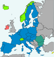
In Italy national Identity cards are not compulsory for citizens aged 15 or over. Could you please amend the colour of Italy in your map from pink to yellow? — Preceding unsigned comment added by Saxkite (talk • contribs)
Okay thanks, I will do as soon as I can. I don't have Inkscape right now so it will have to wait until the weekend when I have time to install it. Rob984 (talk) 22:55, 3 February 2016 (UTC)Reply
Latest comment: 7 years ago4 comments2 people in discussion
Hi, thanks for your edits to this. However, is it possible to create an the same one to Africa. This file (File:UTC hue4map X region Africa.png) is outdated and Egypt is currently implementing DST next month and the current map doesn't fit very well.
Time zones in Africa include:
1) Cape Verde Time (UTC-1) - put in orange
Countries: Cape Verde only
2) Greenwich Mean Time (UTC) - put in light blue
Countries: Burkina Faso, Cote d'Ivoire, the Gambia, Ghana, Guinea, Guinea-Bissau, Liberia, Mali, Mauritania, São Tomé and Príncipe, Senegal, Sierra Leone, Togo and Western Sahara
3) Western European Time / Greenwich Mean Time (UTC)
Western European Summer Time (UTC+1) - put in dark blue
Countries: Morocco only
4) Central European Time / West Africa Time (UTC+1) - put in light red
Countries: Algeria, Angola, Benin, Chad, Cameroon, Central African Republic, Western D.R. Congo, Equatorial Guinea, Gabon, Niger, Nigeria, Republic of the Congo, Tunisia
5) West Africa Time (UTC+1)
West Africa Summer Time (UTC+2) (for Namibia only) - put in dark red
Countries: Namibia
6) Eastern European Time / Central Africa Time / South Africa Standard Time (UTC+2) - put in yellow
Countries: Burundi, Botswana, Eastern D.R. Congo, Libya, Malawi, Mozambique, Rwanda, South Africa, Swaziland, Zambia and Zimbabwe
7) Eastern European Time (UTC+2)
Eastern European Summer Time (UTC+3) - put in golden
Countries: Egypt only
8) Eastern Africa Time (UTC+3) - put in green
Countries: Comoros, Djibouti, Eritrea, Ethiopia, Kenya, Madagascar, Somalia, South Sudan, Sudan, Tanzania and Uganda
9) Mauritius Time / Seychelles Time (UTC+4) - put in purple
Countries: Mauritius and Seychelles only
Is there any suggestion to make the map of time zones in Africa and make it the similar one to European one? Since you have removed the non-European countries on the Europe time zones map, is it possible to make an African one and place it to the homepage? Thanks --cyrfaw (talk) 15:03, 11 June 2016 (UTC)Reply
Sorry, I'm currently under development of the African map time zone. I will try to upload it when its finished and you're welcome to change any mistakes. ---cyrfaw (talk) 15:34, 11 June 2016 (UTC)Reply
I can't edit files at the moment because my normal laptop is getting repaired (I'm using an old MacBook so I don't have either MS Paint or Inkscape for making a bitmap or vector). But yes, it shouldn't be too difficult to create a bitmap version. If nothing more, just recolour File:UTC hue4map X region Africa.png as you want it using MS Paint.
I suggest for the new file, you also don't colour European or Asian countries.
Thank you for your time, I have completed and uploaded the file right here, but the problem is that D.R. Congo (East and West) needs to be separated with UTC+1 and UTC+2. Any questions? --cyrfaw (talk) 16:01, 11 June 2016 (UTC)Reply
Latest comment: 7 years ago2 comments2 people in discussion
Hi, I noticed you recently uploaded File:Council of Europe (orthographic projection).svg. I just wanted to note that you entirely omitted the Sakhalin Oblast of Russia. You also left Kosovo grey while colouring all of the other breakaway states green. Either leave all of them grey or leave all of them green. You also omitted Transnistria and Nagorno-Karabakh which are also two breakaway states of Council of Europe members. Northern Cyprus also has strange darker disputed borders that differ from the rest, why is that? I wanted to also ask you to return to our discussion on Time of Europe as I wanted to get your response on the issues I pointed out with you map of Europe. --Turnless (talk) 06:40, 7 July 2016 (UTC)Reply
If you created this file, please note that the fact that it has been proposed for deletion does not necessarily mean that we do not value your kind contribution. It simply means that one person believes that there is some specific problem with it, such as a copyright issue. Please see Commons:But it's my own work! for a guide on how to address these issues.
Please remember to respond to and – if appropriate – contradict the arguments supporting deletion. Arguments which focus on the nominator will not affect the result of the nomination. Thank you!
Latest comment: 7 years ago2 comments2 people in discussion
Greetings.
Turkey and Northern Cyprus have abolished daylight saving and are permanently fixed on en:UTC+3 (en:Further-eastern European Time). (Also Crimea has not been updated in some of these files which is also permanently fixed on UTC+3.) See the news and sources. Can you change these files accordingly?
Can you do these changes for Turkey and Northern Cyprus by copying the latest updates from the File:Time zones of Europe (Crimea disputed).svg except that Crimea is colored totally in green, for these additional files below? Many cross-Wikipedia articles use these files which are not updated.
If you created this file, please note that the fact that it has been proposed for deletion does not necessarily mean that we do not value your kind contribution. It simply means that one person believes that there is some specific problem with it, such as a copyright issue. Please see Commons:But it's my own work! for a guide on how to address these issues.
Please remember to respond to and – if appropriate – contradict the arguments supporting deletion. Arguments which focus on the nominator will not affect the result of the nomination. Thank you!
I retracted the deletion request, since the necessary changes were made to keep this file distinct (and must remain so) so it can stay. And I think the administrators will decide to keep it (The administrators are the ones who are allowed to close the deletion request, so I cannot close it myself as an ordinary user, and very likely they will close it). I originally requested it when I saw the file was identical and had no Wikipedia links.
You can erase my message (and the deletion request) in you user page if you wish.
Latest comment: 7 years ago2 comments2 people in discussion
Hello.
Could you update the File:Standard time zones of the world.svg by taking the changes in Crimea, Abkhazia, South Ossetia, North Korea, Turkey and Northern Cyprus into account, by copying the latest updates from the File:Standard World Time Zones.png? I requested this because I don't know how to create and upload SVG files myself.
@Maphobbyist sorry I can't take requests, I don't really have the time any more. Also I'm not an expert at working with graphics so there is probably someone else who can do it with less difficultly than myself. You can make a request somewhere like Wikipedia:Graphics Lab/Illustration workshop where a lot of contributors will see the request, especially since it is a straightforward bitmap to vector job. Rob984 (talk) 22:54, 11 October 2016 (UTC)Reply
Latest comment: 7 years ago2 comments1 person in discussion
I don't want to make an edit war, so I've started a discussion on the talk page for the map here that you might be interested in contribute to. Thank you. --Salem Leo (talk) 23:04, 10 December 2016 (UTC)Reply
Got your message. However, I would like to note that ISIS/Daesh now controls a large chunk of that highway and has taken over a majority of the desert, according to here. I would like to hear your input on this on the talk page. Thanks. --Salem Leo (talk) 00:36, 22 December 2016 (UTC)Reply
If you created this file, please note that the fact that it has been proposed for deletion does not necessarily mean that we do not value your kind contribution. It simply means that one person believes that there is some specific problem with it, such as a copyright issue. Please see Commons:But it's my own work! for a guide on how to address these issues.
Please remember to respond to and – if appropriate – contradict the arguments supporting deletion. Arguments which focus on the nominator will not affect the result of the nomination. Thank you!
Latest comment: 6 years ago1 comment1 person in discussion
Dear Rob984,
Can you kindly safe your once fine - especially correct and source-based - map to the version as of 7 November 2017? Safe it from discretionary changes, not to say rape...
Thanks and all the best, 85.246.33.9120:48, 16 January 2018 (UTC)Reply
Latest comment: 5 years ago14 comments2 people in discussion
Hi,
Using Pantone 280 actually results in a distortion of the color of the Flag of NATO. Furthermore, there is an alternative 3:5 ratio that is used by NATO. I believe that a very early guideline provided for a 3:4 ratio and this is the ratio in which I found a flag of NATO online in 2013, the basis of the current NATO flag on the Commons. I think we need to provide both the 3:5 ratio and the 3:4 ratio, and correct the color.
Link to the already existing 3:4 ratio: Flag of NATO.svg
Color guidelines are on page 6.
I uploaded the 3:5 ratio I found in the Visual Identity Guidelines Flag of NATO 3-5 ratio.svg
Thanks. 475847394d347339 (talk) 21:49, 24 July 2018 (UTC)Reply
The RGB values are supposed to be 0-73-144. You have here 1-33-105. Thanks. I tried to use Inkscape but am having trouble using the bucket tool. 22:13, 24 July 2018 (UTC) — Preceding unsigned comment added by 475847394d347339 (talk • contribs) 22:13, 24 July 2018 (UTC)Reply
"Please note: The above CMYK definition of the logo colours is not based on the computer-generated automatic conversion of PMS colours into CMYK, or vice versa, but has been made as a deliberate, conscientious choice to obtain a stronger visual impact."
This is a depiction of the flag not the logo. The flag only has one colour. It's not clear this guideline would also apply to a digital depiction of the flag, and even if there was such a guideline, I'm not sure Wikipedia would want to show a colour that differs from real-life for "a stronger visual impact".
Ok then. They have changed their use of colors, apparently. The also provide a flag with a 3:5 ratio on page 14. Don't know what Wikipedia or Wikimedia Commons should put forward. 475847394d347339 (talk) 22:24, 24 July 2018 (UTC)Reply
Let's change the color of the 3:4 ratio flag to RGB 0-73-144. We can put all three usages, 3:4 ratio Pantone 280, 3:4 ratio RGB 0-73-144, and the 3:5 ratio 0-73-144 I found in the document. We can note the variations on usage in Wikipedia articles. 475847394d347339 (talk) 22:34, 24 July 2018 (UTC)Reply
@475847394d347339 If there's a source for the flag specifically using a different colour in digital depictions then it's something that could be discussed, but other then from this one instance of the flag in the guideline, we can't say for sure. As far as I know the colour has always been Pantone 280, and this can't really be depicted on a flag in a different way. Our depiction of the flag is of the real-life flag. As for the ratio, I don't have any idea honestly. I can't just change the ratio of the flag and upload it for you, since this requires research into how a 3:5 variant should be constructed (size of the elements, padding around them, etc.).
I recommend you take your proposals to the talk page of the EN:W:Flag of NATO article. I don't really have time to help right now.
If you created this file, please note that the fact that it has been proposed for deletion does not necessarily mean that we do not value your kind contribution. It simply means that one person believes that there is some specific problem with it, such as a copyright issue. Please see Commons:But it's my own work! for a guide on how to address these issues.
Please remember to respond to and – if appropriate – contradict the arguments supporting deletion. Arguments which focus on the nominator will not affect the result of the nomination. Thank you!
Latest comment: 4 years ago1 comment1 person in discussion
Share your experience in this survey
Hi Rob984,
The Wikimedia Foundation is asking for your feedback in a survey about your experience with Wikimedia Commons and Wikimedia. The purpose of this survey is to learn how well the Foundation is supporting your work on wiki and how we can change or improve things in the future. The opinions you share will directly affect the current and future work of the Wikimedia Foundation.
Latest comment: 4 years ago1 comment1 person in discussion
Share your experience in this survey
Hi Rob984,
A couple of weeks ago, we invited you to take the Community Insights Survey. It is the Wikimedia Foundation’s annual survey of our global communities. We want to learn how well we support your work on wiki. We are 10% towards our goal for participation. If you have not already taken the survey, you can help us reach our goal! Your voice matters to us.
Latest comment: 4 years ago1 comment1 person in discussion
Share your experience in this survey
Hi Rob984,
There are only a few weeks left to take the Community Insights Survey! We are 30% towards our goal for participation. If you have not already taken the survey, you can help us reach our goal!
With this poll, the Wikimedia Foundation gathers feedback on how well we support your work on wiki. It only takes 15-25 minutes to complete, and it has a direct impact on the support we provide.
Latest comment: 4 years ago1 comment1 person in discussion
While Ukraine has not officially left the CIS, label it somehow differently, but not completely remove it from the globe map of the CIS countries. Compu wiki (talk) 05:45, 24 January 2020 (UTC)Reply
I requested this because I don't know how to create and upload SVG files myself. I can only edit PNG and GIF files, where I added the border of South Sudan in hundreds of maps, as long as they are not sophisticated topographical and orthographical maps.
However, if you make the edits in the SVG maps, I can copy and paste them in the PNG duplicates in case they exist.
If you stumble upon current maps where South Sudan is missing and/or where the UK and Gibraltar need to be removed, can you update them, if you are interested?
Latest comment: 3 years ago1 comment1 person in discussion
Many of the countries map you made, a little bit Uzbekistan, Libya, the display of recognized countries is relative, Somaliland (not recognized by any country) is displayed, but some countries recognized Abkhazia, Artakh and Kosovo did not show it. To avoid misleading, please unify the standard and decide whether to show these countries — Preceding unsigned comment added by 47.74.222.169 (talk • contribs)
I agree a lot of it's inconsistent and arbitrary. If I make changes/update a map I will typically address it problems, but it's not a priority right now. I recommend learning to edit vector files and making the corrections yourself. Inkscape has a learning curve but it's a great piece of software once you get the hang of it. Rob984 (talk) 12:58, 1 October 2020 (UTC)Reply
Latest comment: 3 years ago1 comment1 person in discussion
These pictures all show Somaliland, a regime that is not recognized by any country, but Kosovo Abkhazia and South Ossetia other countries recognized by more countries do not show that the national boundary should be in accordance with the standards recognized by the United Nations rather than double standards. — Preceding unsigned comment was added by 47.74.222.169 (talk) 09:47, 25 December 2020 (UTC)Reply
Latest comment: 3 years ago1 comment1 person in discussion
Dear Rob984,
As the UK-EU Trade and Cooperation Agreement has been recently published, there is provision within this stating that the United Kingdom shall participate in all parts of the Euratom programme as an associated state.
This is outlined within the Draft EU-UK Declarations which are annexed to the Agreement: Draft EU-UK Declarations
Specifically, Article 7 of Protocol 1 (Programmes and activities in which the United Kingdom participates) within the Join Declaration on Participation in Union Programmes and Access to Programme Services [Located on p.21 of the document] states that "The United Kingdom shall participate as an associated country in all parts of the Euratom Programme."
Would it be possible - perhaps from the implementation of the Agreement from 1 January 2021 - to update the map on the current Euratom programme Wiki page to shade the United Kingdom as an associated state?
Latest comment: 2 years ago2 comments2 people in discussion
This work of yours, you need to adjust it. Romania was not a Soviet satellite for virtually its entire tenure as a Pact member. A new, well-referenced article exists to show just that: Romania's de-satellization. A few choice aspects I'll mention here - sourced and in that article: the Red Army left Romanian territory in 1958, and all Soviet advisors were likewise withdrawn in 1964, Romania ceased active participation in Pact exercises by 1962, never again allowing Pact/Soviet forces on its territory, not even for training, Romania refused a Soviet request to build a rail through its territory to Bulgaria and 1974 and voted against the Soviet Union in the UN Assembly in 1979, it ignored the boycott of the 1984 Olympics and much more. We also have multiple sources literally mentioning Romania's desatellization. All these considered, I urge you to make Romania a lighter shade of green. Though darker than Albania, for obvious reasons. Transylvania1916 (talk) 05:28, 12 June 2021 (UTC)Reply
User:Transylvania1916 as this is an editorial request, can you bring up this change at W:Talk:Warsaw Pact? I made the map based on the previous map and I'm not sure if there would be consensus to show Romania in a different shade. It's simply showing membership of the pact in 1990 so it's not inaccurate. Rob984 (talk) 20:12, 19 October 2021 (UTC)Reply
If you created this file, please note that the fact that it has been proposed for deletion does not necessarily mean that we do not value your kind contribution. It simply means that one person believes that there is some specific problem with it, such as a copyright issue. Please see Commons:But it's my own work! for a guide on how to address these issues.
Please remember to respond to and – if appropriate – contradict the arguments supporting deletion. Arguments which focus on the nominator will not affect the result of the nomination. Thank you!
Latest comment: 2 years ago2 comments2 people in discussion
Hello.
Can you change the de-facto border inside Azerbaijan in File:Europe-UK.svg and File:EU-Gibraltar.svg, and in related Europe SVG and PNG maps in the same format? After the Second Nagorno-Karabakh War in 2020, the territory controlled by Armenians is much reduced. The current situation on the ground, should be reflected in the maps. If that is too challenging, can you get rid of all the de facto borders, including in Cyprus, for consistency?
Latest comment: 2 years ago1 comment1 person in discussion
The depiction of the berms is very incorrect on this map, due to the poor but often used source. There is a correct map available from Google Maps. Could you at some time correct the map here?--Antemister (talk) 14:10, 19 December 2021 (UTC)Reply
Latest comment: 1 year ago1 comment1 person in discussion
Some contents have been listed at Commons:Deletion requests so that the community can discuss whether they should be kept or not. We would appreciate it if you could go to voice your opinion about this at their entry.
If you created these pages, please note that the fact that they have been proposed for deletion does not necessarily mean that we do not value your kind contribution. It simply means that one person believes that there is some specific problem with them, such as a copyright issue. Please see Commons:But it's my own work! for a guide on how to address these issues.
Please remember to respond to and – if appropriate – contradict the arguments supporting deletion. Arguments which focus on the nominator will not affect the result of the nomination. Thank you!
If you created this file, please note that the fact that it has been proposed for deletion does not necessarily mean that we do not value your kind contribution. It simply means that one person believes that there is some specific problem with it, such as a copyright issue. Please see Commons:But it's my own work! for a guide on how to address these issues.
Please remember to respond to and – if appropriate – contradict the arguments supporting deletion. Arguments which focus on the nominator will not affect the result of the nomination. Thank you!


.svg)
.svg)
.png)
.svg)
.svg)
.svg)
.svg)

.svg)
.svg)
.png)
.svg)
.svg)
.svg)
.svg)
.svg)
.svg)
.svg)
.svg)
.svg)
.svg)
.svg)
.svg)
.svg)
.svg)
.svg)
.svg)