Category:Berkshire
(Redirected from Berkshire)
ceremonial but non-administrative county of England  Дорога к Виндзорскому замку   | |||||
| Upload media | |||||
| Instance of |
| ||||
|---|---|---|---|---|---|
| Named after | |||||
| Location |
| ||||
| Capital | |||||
| Population |
| ||||
| Area |
| ||||
| Different from | |||||
| Said to be the same as | Berkshire (historic county of England, ceremonial county of England, 1844) | ||||
 | |||||

Deutsch: Berkshire ist eine Grafschaft im Süden Englands.
English: Berkshire is a county in southern England.
Français : Berkshire est une comté du sud de l'Angleterre.
Nederlands: Berkshire is een graafschap in Engeland.
Norsk bokmål: Berkshire er et grevskap i det sørlige England.
Subcategories
This category has the following 42 subcategories, out of 42 total.
*
- Videos from Berkshire (2 F)
A
B
- Boundary stones in Berkshire (8 F)
C
E
G
- Gallery pages of Berkshire (4 P)
H
- Healthcare in Berkshire (2 F)
I
L
M
N
O
P
Q
S
T
U
V
- Valued images of Berkshire (6 F)
Media in category "Berkshire"
The following 62 files are in this category, out of 62 total.
-
-
 A Pond In The Berkshires In The Spring (218237505).jpeg 2,048 × 1,152; 734 KB
-
 Access to Racecourse marina (24566050523).jpg 3,648 × 2,432; 1.63 MB
-
 Baxter Healthcare - geograph.org.uk - 1154113.jpg 640 × 427; 219 KB
-
 Berkshire - Heathrow Scenery (geograph 5257336).jpg 6,000 × 4,000; 7.53 MB
-
 Beyou-logo.jpg 153 × 47; 13 KB
-
 Bricked up door - geograph.org.uk - 1711748.jpg 1,024 × 683; 160 KB
-
 CJ Rolfe ^ Son - panoramio.jpg 1,952 × 3,264; 1.63 MB
-
 Cobbled pathway (5214049577).jpg 4,349 × 2,693; 6.61 MB
-
 County Flag of Berkshire (commercial version).svg 552 × 333; 66 KB
-
 Elementary jumps - geograph.org.uk - 597497.jpg 640 × 477; 88 KB
-
En-Berkshire.ogg 0.7 s; 14 KB
-
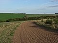
 Farmland on Roden Downs - geograph.org.uk - 3635508.jpg 640 × 419; 116 KB
-
 Fawley War Memorial - geograph.org.uk - 1746862.jpg 1,734 × 2,428; 1.54 MB
-
 Forbury Road by night (94220402).jpg 1,280 × 1,024; 499 KB
-
 Goring Gap (5815211932).jpg 1,600 × 1,067; 212 KB
-
 Goring Panorama Banner.jpg 8,400 × 1,200; 11.4 MB
-
 Gun steadies in the floor - geograph.org.uk - 1714696.jpg 1,024 × 768; 187 KB
-
 Hangman's Stone Leckhampstead Berks. - geograph.org.uk - 946309.jpg 640 × 483; 183 KB
-
 Houses in Bridgewater, Connecticut.jpg 5,184 × 3,456; 6.19 MB
-
 Illegible - panoramio.jpg 1,952 × 3,264; 1.31 MB
-
 Kennet Canal Lock Gate (42738672740).jpg 14,840 × 6,000; 60.5 MB
-
 M4 crossing the B4494 north of Newbury - geograph.org.uk - 1250050.jpg 640 × 480; 100 KB
-
 Man carrying kayak while woman tries to take photo (4849444376).jpg 2,465 × 2,068; 4.13 MB
-
 Map showing the traditional, geographical county of Berkshire, England.png 4,967 × 4,967; 4.35 MB
-
 Marsh Common Sign, Weston, Berkshire.jpg 1,536 × 2,048; 1.59 MB
-
 Misty wharf (6364238203).jpg 3,870 × 2,118; 4.19 MB
-
 New building near Penclose Cottage - geograph.org.uk - 596332.jpg 640 × 477; 96 KB
-
 Nice (2105540002).jpg 640 × 480; 117 KB
-
 North-western exit to Greenham Common - geograph.org.uk - 1187334.jpg 425 × 640; 188 KB
-
 Number on the wall - geograph.org.uk - 1713229.jpg 533 × 800; 93 KB
-
 Oakley Court (24562254754).jpg 2,000 × 3,000; 1.55 MB
-
 Pangbourne Sun 007.jpg 3,072 × 2,304; 868 KB
-
 Pole (4696093249).jpg 3,415 × 2,331; 2.77 MB
-

-
 Ripples (4395280067).jpg 2,592 × 2,053; 3.36 MB
-
 Ripples Cropped (4398304361).jpg 867 × 1,413; 728 KB
-
 River Lambourn at Easton (1) - geograph.org.uk - 1659061.jpg 640 × 480; 134 KB
-
 Ryeish Green, Berkshire - geograph-2254732.jpg 1,800 × 1,200; 951 KB
-
 Salt Box - geograph.org.uk - 1718704.jpg 1,600 × 1,153; 364 KB
-
 Seagull (6453269891).jpg 4,746 × 2,610; 9.19 MB
-
 Stables - geograph.org.uk - 8733.jpg 640 × 346; 249 KB
-
 Stick reflection (4372349513).jpg 2,806 × 2,076; 2.94 MB
-
 Swanlake.jpg 4,608 × 3,456; 4.52 MB
-
 Thames Valley UK PCC election 2024.svg 597 × 673; 651 KB
-

-
 Tittenhurst - geograph.org.uk - 707.jpg 640 × 427; 46 KB
-
 Two of the points - geograph.org.uk - 1736288.jpg 1,024 × 683; 105 KB
-
 Umpachene Falls, May 2014.jpg 1,200 × 797; 758 KB
-
 Vapour trails, Ashampstead - geograph.org.uk - 678154.jpg 640 × 480; 68 KB
-
 Vending machine (94220894).jpg 1,280 × 1,024; 328 KB
-
 View from the B4494 - geograph.org.uk - 854374.jpg 640 × 427; 78 KB
-
 Weir at Padworth Mill - geograph.org.uk - 1189273.jpg 640 × 427; 191 KB
-
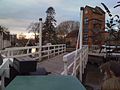 West Mills Swing Bridge - panoramio.jpg 1,600 × 1,200; 689 KB
-
 White Hart Inn and Restaurant - geograph.org.uk - 1534204.jpg 640 × 426; 171 KB
-
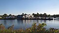 Windsor marina (25166554036).jpg 3,648 × 2,048; 1.65 MB
-
 Eastbury Down - geograph.org.uk - 228694.jpg 640 × 480; 152 KB
-
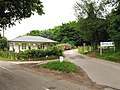 Entrance to Training Centre, Sulhamstead - geograph.org.uk - 22978.jpg 640 × 480; 455 KB
-
 Gallops on the Ridgeway. - geograph.org.uk - 67226.jpg 640 × 480; 111 KB
-
 Manor Farm B and B - geograph.org.uk - 20823.jpg 640 × 480; 289 KB
-
 The Old Workhouse - geograph.org.uk - 89659.jpg 597 × 370; 53 KB
-

,_England._LOC_7419835712.jpg)
.jpeg)
.jpg)

.jpg)


.jpg)
.svg)


.jpg)
.jpg)


.jpg)


.jpg)

.jpg)


.jpg)

.jpg)
_-_geograph.org.uk_-_950598.jpg)
.jpg)
.jpg)
_-_geograph.org.uk_-_1659061.jpg)


.jpg)

.jpg)


.jpg)


.jpg)


.jpg)