Category:1770s maps of Italy
Countries of Europe: Albania · Armenia‡ · Azerbaijan‡ · Belgium · Cyprus‡ · Denmark · France‡ · Georgia‡ · Germany · Greece · Republic of Ireland · Italy · Lithuania · Moldova · Montenegro · Netherlands‡ · Norway · Poland · Portugal‡ · Romania · Russia‡ · Serbia · Spain‡ · Sweden · Switzerland · Turkey‡ · Ukraine · United Kingdom
Limited recognition: Abkhazia‡
‡: partly located in Europe
Limited recognition: Abkhazia‡
‡: partly located in Europe
- Regions of Italy: Liguria ·
Subcategories
This category has the following 6 subcategories, out of 6 total.
- 1770 maps of Italy (1 F)
- 1777 maps of Italy (3 F)
- 1779 maps of Italy (1 F)
.
Media in category "1770s maps of Italy"
The following 6 files are in this category, out of 6 total.
-
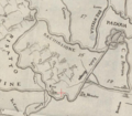 Carta idrografica del Veronese, Polesine e Padouano, 1777.png 640 × 561; 588 KB
-

-

-

-

-
 Altenberg Atlas Tyrolensis 1774.png 744 × 516; 452 KB

_Robert_de_Vaugondy_G%C3%A9ographe_ord(inaire)_du..._-_btv1b550137444_(103_of_183).jpg)
_Robert_de_Vaugondy_G%C3%A9ographe_ord(inaire)_du..._-_btv1b550137444_(106_of_183).jpg)
_Robert_de_Vaugondy_G%C3%A9ographe_ord(inaire)_du..._-_btv1b550137444_(109_of_183).jpg)

