Category:1790s maps of Georgia (U.S. state)
States of the United States: Alaska · Connecticut · Delaware · Florida · Georgia · Indiana · Kentucky · Louisiana · Maine · Maryland · Massachusetts · Missouri · New Hampshire · New Jersey · New York · North Carolina · Ohio · Pennsylvania · Rhode Island · South Carolina · Tennessee · Vermont – Washington, D.C.
Puerto Rico
Puerto Rico
Media in category "1790s maps of Georgia (U.S. state)"
The following 3 files are in this category, out of 3 total.
-
 A chart of South Carolina and Georgia (3045498341).jpg 1,629 × 2,000; 3.15 MB
-
 Georgia, from the latest authorities. LOC gm71000975.jpg 5,103 × 3,866; 2.26 MB
-
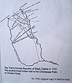 Map of Trans-Oconee Republic of Elijah Clarke.jpg 831 × 960; 88 KB
.jpg)
