Category:1800s maps of Austria
States of Austria:
Media in category "1800s maps of Austria"
The following 3 files are in this category, out of 3 total.
-
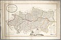 Neueste Karte des Erzherzogthums Oesterreich Ob und Unter der Enns.jpg 12,290 × 8,123; 16.92 MB
-
 Das Kurfürstenthum Salzburg... - btv1b53119439p (1 of 2).jpg 6,859 × 8,383; 11.9 MB
-
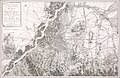 1808 map Vienna and surroundings.jpg 23,433 × 15,269; 94.36 MB

.jpg)
