Category:1800s maps of Finland
Countries of Europe: Armenia‡ · Austria · Azerbaijan‡ · Belarus · Belgium · Bosnia and Herzegovina · Bulgaria · Croatia · Cyprus‡ · Czech Republic · Denmark · Estonia · Finland · France‡ · Georgia‡ · Germany · Greece · Hungary · Republic of Ireland · Italy · Latvia · Lithuania · Netherlands‡ · Norway · Poland · Portugal‡ · Romania · Russia‡ · Serbia · Slovenia · Spain‡ · Sweden · Switzerland · Turkey‡ · Ukraine · United Kingdom
Limited recognition: Abkhazia‡
‡: partly located in Europe
Limited recognition: Abkhazia‡
‡: partly located in Europe
Subcategories
This category has only the following subcategory.
1
Media in category "1800s maps of Finland"
The following 12 files are in this category, out of 12 total.
-
 Nordenkart, 1800. Høyre side (12235512534).jpg 10,080 × 12,404; 30.2 MB
-

-
 Lassilan kylä 1808.jpg 929 × 1,200; 162 KB
-
 Map of Sweden Wellcome V0049917.jpg 3,000 × 2,329; 2.76 MB
-

-
 Finlandia map (1808).jpg 1,146 × 912; 276 KB
-
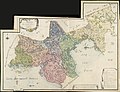 Finljandskaja Gubernia 1803.jpg 13,698 × 10,470; 15.68 MB
-
 Kukonharju 1800.jpg 400 × 167; 21 KB
-
 Slaget vid Alavo.jpg 2,371 × 2,473; 1.67 MB
-
 Slaget vid Käkelä.jpg 3,301 × 1,973; 1.75 MB
-
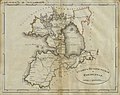 St. Peterburg and Finland Governorate map (1808).jpg 1,146 × 912; 238 KB
-
 Wäg-Karta öfver Finland.jpg 6,321 × 5,783; 10.01 MB
.jpg)
,_ing(%C3%A9nieur),_g%C3%A9og(raphe)_;_grav%C3%A9_par_Tardieu_a%C3%AFn%C3%A9_;_%C3%A9crit_pas_Giraldon_-_btv1b10678616m.jpg)


,_de_25_Lieues_communes_de_France_(%3D0m._054)_;_de_12_Milles_de_Finlande_-_btv1b8490364h.jpg)
.jpg)


.jpg)
