Category:1800s maps of India
Subcategories
This category has the following 5 subcategories, out of 5 total.
- 1800 maps of India (6 F)
- 1804 maps of India (3 F)
- 1805 maps of India (6 F)
- 1806 maps of India (2 F)
- 1808 maps of India (3 F)
Media in category "1800s maps of India"
The following 4 files are in this category, out of 4 total.
-
 Atlas moderne portatif 1804 (84188575).jpg 6,392 × 5,289; 4.07 MB
-
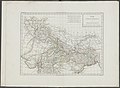 Atlas elementaire portatif 1807 (139437952).jpg 14,380 × 10,563; 189.18 MB
-
 Atlas elementaire portatif 1807 (139437977).jpg 14,350 × 10,561; 176.83 MB
-
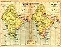 India1765and1805b.jpg 1,227 × 950; 307 KB
.jpg)
.jpg)
.jpg)
