Category:1854 maps of Massachusetts
States of the United States: California · Georgia · Massachusetts · New York · Ohio · Oregon · Pennsylvania · Texas
| ← 1850 1851 1852 1853 1854 1855 1856 1857 1858 1859 → |
Media in category "1854 maps of Massachusetts"
The following 14 files are in this category, out of 14 total.
-
 1854 AsaGray CambridgeMA map byWalling BPL 12775.png 794 × 690; 1.04 MB
-
 1854 EastCambridgeMA map byWalling BPL 12775.png 937 × 745; 1.18 MB
-
 1854 Map of the city of Cambridge, Middlesex County, Massachusetts (3887215674).jpg 2,000 × 1,680; 3.14 MB
-
 1854 Rail Road Map of the New England States.jpg 10,752 × 9,328; 29.53 MB
-

-
 Map of Hampshire County, Massachusetts (3120846060).jpg 2,000 × 1,492; 3.33 MB
-
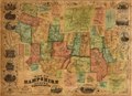
 Map of Hampshire County, Massachusetts LOC 2008624301.jpg 16,339 × 11,866; 30.18 MB
-
 Map of Hampshire County, Massachusetts LOC 2008624301.tif 16,339 × 11,866; 554.69 MB
-
 Map of parts of Boston Harbor and its tributaries (2675742374).jpg 1,542 × 2,000; 1.55 MB
-
 Map of the town of Lenox Berkshire Co. Massachusetts (2673912221).jpg 1,830 × 2,000; 3.27 MB
-
 Map of the town of Lenox, Massachusetts (3369698713).jpg 1,910 × 2,000; 3.19 MB
-
 Map of the town of Winchester, Middlesex County, Mass. (7557376624).jpg 6,285 × 4,248; 25.28 MB
-

-


.jpg)


.jpg)

.jpg)
.jpg)
.jpg)
.jpg)
.jpg)
.jpg)