Category:1869 maps of Massachusetts
States of the United States: California · Illinois · Iowa · Massachusetts · Missouri · New York · Oregon
| 1860 1861 1862 1863 1864 1865 1866 1867 1868 1869 → |
Media in category "1869 maps of Massachusetts"
The following 11 files are in this category, out of 11 total.
-
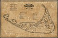 Historical map of Nantucket (2675205896).jpg 2,000 × 1,309; 2.43 MB
-
 Map of Boston from the latest surveys (2675357430).jpg 2,000 × 1,334; 2.5 MB
-
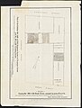
 Map Of Site - NARA - 85967583.jpg 8,352 × 5,884; 3.34 MB
-
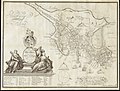
 Nanitz great mercantile map of Boston. (2675949714).jpg 2,000 × 1,687; 3.13 MB
-
 Plan for the Occupation of Flats Owned by the Commonwealth in Boston Harbor, 1869.jpg 11,820 × 7,632; 29.02 MB
-
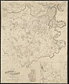 Plan of Boston and its vicinity (2674540871).jpg 1,642 × 2,000; 2.86 MB
-
 Plan of Boston, with additions and corrections (2674544019).jpg 2,000 × 1,330; 2.29 MB
-

-

-
-
.jpg)
.jpg)

.jpg)

.jpg)
.jpg)
.jpg)
.jpg)
.jpg)
.jpg)