Category:1870s maps of Berlin
|
Federal states of Germany: |
Media in category "1870s maps of Berlin"
The following 24 files are in this category, out of 24 total.
-
 Birds-Eye View of Berlin 1870.jpg 1,925 × 2,689; 1.78 MB
-
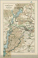
 The Rhine and northern Germany- handbook for travellers (1870) (14785943483).jpg 3,694 × 2,484; 4 MB
-
 VORONTSOV(1870) p8.483 Рейд на Берлин (1760).jpg 3,081 × 2,721; 4.64 MB
-
 Berliner Lebens- und Vergnügungs-Plan (1871).jpg 2,048 × 1,767; 2.94 MB
-
 Meinhardt, Ansicht von Berlin aus der Vogelperspektive, 1871.jpg 3,049 × 2,261; 6.16 MB
-
 Sineck Grundriss von Berlin 1871.jpg 10,554 × 8,797; 37.67 MB
-
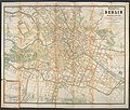
 Straube Neuester-Plan von Berlin 1872.jpg 5,621 × 5,532; 8.75 MB
-
 Berlin und Umgegend 1873.jpg 1,539 × 1,500; 1.7 MB
-

-
 Die Jungfernheide und der Grunewald 1875.jpg 1,552 × 2,316; 1.81 MB
-
 Grundriss von Berlin 01.jpg 9,818 × 8,314; 17.88 MB
-
 Neuer Plan von Berlin und Umgebung 1875.jpg 8,492 × 7,983; 35.26 MB
-
-
-

-

-
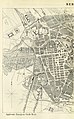
 Baedeker Stadtplan Berlin 1877.jpg 4,461 × 3,174; 12.12 MB
-
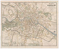
 Ravenstein Plan von Berlin 1877.jpg 7,306 × 5,454; 15.81 MB
-
 Blumenstraßenkrawalle - 1872.png 1,712 × 2,283; 2.25 MB
-

-
 Lageplan der Chemischen Fabrik Kanne.jpg 3,000 × 2,214; 1.26 MB
-
-

-


_(14785943483).jpg)
_p8.483_%D0%A0%D0%B5%D0%B9%D0%B4_%D0%BD%D0%B0_%D0%91%D0%B5%D1%80%D0%BB%D0%B8%D0%BD_(1760).jpg)
.jpg)


.jpg)
.jpg)
.jpg)
.jpg)


,_RP-F-2001-7-160-25_(cropped).jpg)


