Category:1872 maps of Massachusetts
States of the United States: California · Illinois · Massachusetts · Michigan · New York · Oregon · Pennsylvania · Texas · Utah · Wyoming – Washington, D.C.
| ← 1870 1871 1872 1873 1874 1875 1876 1877 1878 1879 → |
Media in category "1872 maps of Massachusetts"
The following 11 files are in this category, out of 11 total.
-
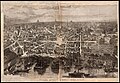 1872 bird's eye view map of Boston after the Great Fire.jpg 9,176 × 6,336; 10.29 MB
-

-

-
 Bird's-eye view of Boston, showing the burned district 01.jpg 7,272 × 5,200; 18.01 MB
-
 Birds-eye view of Boston, showing the burned district (2676005156).jpg 2,000 × 1,456; 2.89 MB
-

-

-
 Map of Boston 1872 (7557398876).jpg 6,718 × 4,494; 28.59 MB
-
 Map of Boston and the country adjacent, from actual surveys (2675444036).jpg 1,567 × 2,000; 3.13 MB
-
 Map of the city of Lynn Massachusetts (3886418663).jpg 2,000 × 1,547; 2.88 MB
-
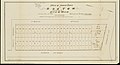 Plan of house lots in Boston belonging to Otis H. Weed (3120133737).jpg 2,000 × 1,089; 1.59 MB


_(14735402636).jpg)

.jpg)
.jpg)
_(3369693159).jpg)
.jpg)
.jpg)
.jpg)
.jpg)