Category:1880s maps of Rhode Island
States of the United States: Alabama · Alaska · Arizona · Arkansas · California · Colorado · Connecticut · Delaware · Florida · Georgia · Hawaii · Idaho · Illinois · Indiana · Iowa · Kansas · Kentucky · Louisiana · Maine · Maryland · Massachusetts · Michigan · Minnesota · Mississippi · Missouri · Montana · Nebraska · Nevada · New Hampshire · New Jersey · New Mexico · New York · North Carolina · North Dakota · Ohio · Oklahoma · Oregon · Pennsylvania · Rhode Island · South Carolina · South Dakota · Tennessee · Texas · Utah · Vermont · Virginia · Washington · West Virginia · Wisconsin · Wyoming – Washington, D.C.
Puerto Rico
Puerto Rico
Subcategories
This category has the following 3 subcategories, out of 3 total.
Media in category "1880s maps of Rhode Island"
The following 6 files are in this category, out of 6 total.
-
 1882 ProvidenceRI byBailey BPL 10162.png 1,063 × 715; 1.06 MB
-
 EB9 Rhode Island.jpg 2,752 × 3,883; 1.84 MB
-
 Lonsdale, Rhode Island, 1888. LOC 2008624024.jpg 10,666 × 8,687; 18.77 MB
-
 New England - a handbook for travelers (1880) (14741974336).jpg 3,334 × 2,404; 1.24 MB
-
 Topographic map of Massachusetts and Rhode Island (8345527561).jpg 800 × 509; 82 KB
-
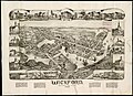 Wickford, Rhode Island - 1888 G3774.N54A3 1888O43.jpg 9,144 × 6,640; 8.89 MB


_(14741974336).jpg)
.jpg)
