Category:1850s maps of Rhode Island
States of the United States: Alabama · Alaska · Arizona · Arkansas · California · Colorado · Connecticut · Delaware · Florida · Georgia · Illinois · Indiana · Iowa · Kansas · Kentucky · Louisiana · Maine · Maryland · Massachusetts · Michigan · Minnesota · Mississippi · Missouri · Montana · Nebraska · Nevada · New Hampshire · New Jersey · New Mexico · New York · North Carolina · North Dakota · Ohio · Oklahoma · Oregon · Pennsylvania · Rhode Island · South Carolina · South Dakota · Tennessee · Texas · Utah · Vermont · Virginia · Washington · Wisconsin · Wyoming – Washington, D.C.
Puerto Rico
Puerto Rico
Media in category "1850s maps of Rhode Island"
The following 7 files are in this category, out of 7 total.
-
-
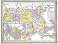
 1855 Colton Map of Massachusetts and Rhode Island - Geographicus - MA-colton-1855.jpg 4,000 × 3,264; 3.2 MB
-

-

-
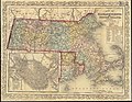 Map of Massachusetts and Rhode Island (8345827651).jpg 800 × 623; 169 KB
-
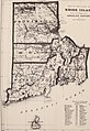
 History of the state of Rhode Island and Providence plantations (1859) (14594857270).jpg 1,884 × 2,832; 673 KB
-
 History of the state of Rhode Island and Providence plantations (1859) (14781219832).jpg 2,056 × 2,988; 863 KB


.jpg)
_(14594857270).jpg)
_(14781219832).jpg)