Category:1850s maps of New Jersey
States of the United States: Alabama · Alaska · Arizona · Arkansas · California · Colorado · Connecticut · Delaware · Florida · Georgia · Illinois · Indiana · Iowa · Kansas · Kentucky · Louisiana · Maine · Maryland · Massachusetts · Michigan · Minnesota · Mississippi · Missouri · Montana · Nebraska · Nevada · New Hampshire · New Jersey · New Mexico · New York · North Carolina · North Dakota · Ohio · Oklahoma · Oregon · Pennsylvania · Rhode Island · South Carolina · South Dakota · Tennessee · Texas · Utah · Vermont · Virginia · Washington · Wisconsin · Wyoming – Washington, D.C.
Puerto Rico
Puerto Rico
Media in category "1850s maps of New Jersey"
The following 15 files are in this category, out of 15 total.
-
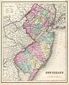
 1850 Cowperthwait - Mitchell Map of New Jersey - Geographicus - NJ-m-50.jpg 2,475 × 3,000; 2.41 MB
-
 Map of Somerset County, New Jersey - entirely from original surveys LOC 2012593680.jpg 11,448 × 13,624; 22.95 MB
-
 Map of Somerset County, New Jersey - entirely from original surveys LOC 2012593680.tif 11,448 × 13,624; 446.23 MB
-
 Map of Hunterdon County, New Jersey - entirely from original surveys LOC 2012592358.jpg 11,525 × 15,651; 26.53 MB
-
 Map of Hunterdon County, New Jersey - entirely from original surveys LOC 2012592358.tif 11,525 × 15,651; 516.07 MB
-
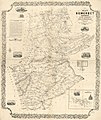
 Map of Monmouth County, New Jersey - from original surveys LOC 2012590163.jpg 17,100 × 12,300; 27.29 MB
-

-

-
 1855 Colton Map of New Jersey - Geographicus - NewJersey-c-1855.jpg 3,263 × 4,000; 2.91 MB
-
 1855 Colton Map of New Jersey - Geographicus - NewJersey-colton-1855.jpg 2,893 × 3,500; 3.2 MB
-
 1857 Colton Map of New Jersey - Geographicus - NewJersey-colton-1857.jpg 2,825 × 3,500; 3.23 MB
-
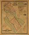 Map of Camden County, New Jersey LOC 2012590162.jpg 12,381 × 14,843; 22.74 MB
-

-
 Admiralty Chart No 2564 Delaware River from Cohansey to Philadelphia, Published 1858.jpg 8,153 × 12,023; 8.49 MB
-
 Hoboken map 1854.jpg 753 × 546; 772 KB


)%27_(11232509463).jpg)
)%27_(11231453664).jpg)


)%27_(11015771943).jpg)

