Category:1900 maps of Michigan
States of the United States: California · Connecticut · Florida · Georgia · Idaho · Illinois · Indiana · Iowa · Kansas · Massachusetts · Michigan · Minnesota · Missouri · Nebraska · New Jersey · New York · North Carolina · North Dakota · Ohio · Oklahoma · Pennsylvania · Rhode Island · South Carolina · South Dakota · Tennessee · Texas · Utah · Vermont · Virginia · Washington · West Virginia · Wisconsin · Wyoming – Washington, D.C.
| ← 1900 1901 1902 1903 1904 1906 1907 1908 1909 → |
Subcategories
This category has the following 15 subcategories, out of 15 total.
P
S
Media in category "1900 maps of Michigan"
The following 29 files are in this category, out of 29 total.
-

-
-

-

-

-
 Plat book of Mecosta County, Michigan LOC 2010592818-29.jpg 5,408 × 8,674; 9.16 MB
-
 Sanborn Fire Insurance Map from Armada, Macomb County, Michigan. LOC sanborn03910 001.jpg 6,510 × 7,707; 3.65 MB
-

-

-

-
 Sanborn Fire Insurance Map from Coleman, Midland County, Michigan. LOC sanborn03969 001.jpg 6,510 × 7,707; 3.84 MB
-
 Sanborn Fire Insurance Map from Concord, Jackson County, Michigan. LOC sanborn03974 002.jpg 6,510 × 7,707; 3.42 MB
-

-
 Sanborn Fire Insurance Map from Croswell, Sanilac County, Michigan. LOC sanborn03978 001.jpg 6,510 × 7,707; 3.78 MB
-
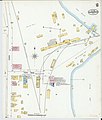
 Sanborn Fire Insurance Map from Farwell, Clare County, Michigan. LOC sanborn04004 002.jpg 6,522 × 7,683; 3.85 MB
-
 Sanborn Fire Insurance Map from L'Anse, Baraga County, Michigan. LOC sanborn04070 002.jpg 6,510 × 7,707; 4.17 MB
-

-
 Sanborn Fire Insurance Map from Linden, Genesee County, Michigan. LOC sanborn04080 002.jpg 6,510 × 7,707; 3.33 MB
-
 Sanborn Fire Insurance Map from Luther, Lake County, Michigan. LOC sanborn04085 002.jpg 6,510 × 7,707; 4.15 MB
-
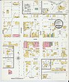
 Sanborn Fire Insurance Map from Marlette, Sanilac County, Michigan. LOC sanborn04097 002.jpg 6,510 × 7,707; 4.06 MB
-

-
-
 Sanborn Fire Insurance Map from Parma, Jackson County, Michigan. LOC sanborn04144 002.jpg 6,510 × 7,707; 3.47 MB
-
 Sanborn Fire Insurance Map from Pewamo, Ionia County, Michigan. LOC sanborn04150 001.jpg 6,510 × 7,707; 3.52 MB
-

-

-

-

-


