Category:1901 maps of the United States
Other areas: Hawaii
States of the United States: California · Hawaii · Idaho · Illinois · Iowa · Kansas · Maryland · Massachusetts · Michigan · Minnesota · New York · North Dakota · Oklahoma · Pennsylvania · Texas · Vermont · Virginia · Wisconsin – Washington, D.C.
Subcategories
This category has the following 22 subcategories, out of 22 total.
A
C
- 1901 maps of California (8 F)
D
- 1901 maps of Washington, D.C. (28 F)
H
- 1901 maps of Hawaii (2 F)
I
K
M
- 1901 maps of Massachusetts (10 F)
- 1901 maps of Minnesota (4 F)
N
- 1901 maps of North Dakota (1 F)
O
- 1901 maps of Oklahoma (1 F)
P
T
- 1901 maps of Texas (6 F)
V
- 1901 maps of Virginia (5 F)
W
Media in category "1901 maps of the United States"
The following 59 files are in this category, out of 59 total.
-

-
 1901 Lake Memphremagog map.png 3,500 × 5,402; 25.54 MB
-
 1901 map of Hartford parks and Hartford Street Railway.jpg 1,268 × 1,013; 300 KB
-
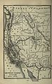 1901 Poor's Southern Pacific Company Pacific System.jpg 2,092 × 3,392; 1.56 MB
-
 1901 White Mountains railroad map.png 3,456 × 3,712; 25.04 MB
-

-

-

-

-

-

-

-

-

-

-

-

-

-

-

-

-

-

-

-

-

-

-

-

-
-

-

-

-

-

-
 Digest of Game Laws for 1901 (1901) (14783634232).jpg 3,488 × 2,160; 465 KB
-
 Europe and other continents (1901) (14577229010).jpg 1,756 × 2,404; 1.04 MB
-
 Europe and other continents (1901) (14577253250).jpg 1,709 × 2,372; 750 KB
-
 Europe and other continents (1901) (14577289728).jpg 1,761 × 2,532; 774 KB
-
 Europe and other continents (1901) (14577295528).jpg 2,528 × 1,690; 1.03 MB
-
 Europe and other continents (1901) (14577316798).jpg 1,752 × 1,824; 650 KB
-
 Europe and other continents (1901) (14740931046).jpg 1,753 × 2,424; 703 KB
-
 Europe and other continents (1901) (14761593434).jpg 1,752 × 2,424; 1.03 MB
-
 Europe and other continents (1901) (14763598102).jpg 1,656 × 2,350; 645 KB
-
 Europe and other continents (1901) (14763931915).jpg 1,686 × 2,414; 827 KB
-
 Europe and other continents (1901) (14763950495).jpg 1,723 × 2,412; 881 KB
-
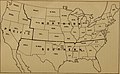
 Fifteenthannualr1901meth 0006.jpg 1,641 × 1,017; 411 KB
-
 Map of the District of Columbia - 1901 LOC 87694449.jpg 8,820 × 8,149; 13.14 MB
-

-

-
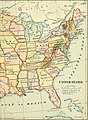
 Map of the United States of America (3855705687).jpg 2,000 × 1,354; 3.49 MB
-

-
 ProspectPark 1901Plan.jpg 4,017 × 2,536; 2.66 MB
-
 Salmon Canneries of the Pacific Northwest. LOC 99446194.jpg 5,346 × 6,782; 6.51 MB
-
 Sketch map of United States of North-America. (1861-65) LOC 99447205.jpg 5,677 × 4,342; 3.68 MB
-
 Sketch map of United States of North-America. (1861-65) LOC 99447205.tif 5,677 × 4,342; 70.52 MB
-

-
 The Street railway journal (1901) (14778659623).jpg 2,560 × 3,445; 777 KB
-
 Yellowstone National Park (1901) (14758874374).jpg 3,248 × 2,742; 1.97 MB
_Plan_of_the_Pan-American_Exposition_to_be_held_at_Buffalo,_New_York,_May_1-Nov_1,_1901,_from_the_Digital_Commonwealth_-_commonwealth_4m90f227c.jpg)


_(14597907379).jpg)
_(14597997587).jpg)
_(14598001317).jpg)
_(14598059877).jpg)
_(14761527996).jpg)
_(14761529386).jpg)
_(14781337351).jpg)
_(14781367631).jpg)
_(14781414641).jpg)
_(14781425941).jpg)
_(14782159994).jpg)
_(14782228604).jpg)
_(14784130912).jpg)
_(14784162702).jpg)
_(14784167332).jpg)
_(14784204362).jpg)
_(14784219672).jpg)
_(14784225322).jpg)
_(14784236362).jpg)
_(14784519935).jpg)
_(14784588425).jpg)
_(14804338143).jpg)
_(14804424773).jpg)
_(14804443033).jpg)
_(14804446703).jpg)

.jpg)

_(14783634232).jpg)
_(14577229010).jpg)
_(14577253250).jpg)
_(14577289728).jpg)
_(14577295528).jpg)
_(14577316798).jpg)
_(14740931046).jpg)
_(14761593434).jpg)
_(14763598102).jpg)
_(14763931915).jpg)
_(14763950495).jpg)


.jpg)
_(14781405142).jpg)


_LOC_99447205.jpg)
.jpg)
_(14778659623).jpg)
_(14758874374).jpg)
_(14781440601).jpg)
_(14804441333).jpg)