Category:1900 maps of the United States
States of the United States: California · Connecticut · Florida · Georgia · Idaho · Illinois · Iowa · Kansas · Massachusetts · Michigan · Minnesota · Missouri · Nebraska · New Jersey · New York · North Carolina · North Dakota · Ohio · Oklahoma · Pennsylvania · Rhode Island · South Carolina · South Dakota · Tennessee · Texas · Utah · Vermont · Virginia · Washington · West Virginia · Wisconsin · Wyoming – Washington, D.C.
Subcategories
This category has the following 34 subcategories, out of 34 total.
C
- 1900 maps of California (3 F)
- 1900 maps of Connecticut (1 F)
D
- 1900 maps of Washington, D.C. (36 F)
F
- 1900 maps of Florida (2 F)
G
I
- 1900 maps of Idaho (5 F)
K
- 1900 maps of Kansas (2 F)
M
- 1900 maps of Massachusetts (20 F)
N
- 1900 maps of Nebraska (6 F)
- 1900 maps of New Jersey (2 F)
- 1900 maps of North Carolina (1 F)
- 1900 maps of North Dakota (1 F)
O
- 1900 maps of Oklahoma (1 F)
P
R
- 1900 maps of Rhode Island (2 F)
S
- 1900 maps of South Carolina (5 F)
- 1900 maps of South Dakota (8 F)
T
- 1900 maps of Tennessee (1 F)
- 1900 maps of Texas (14 F)
U
V
- 1900 maps of Virginia (1 F)
W
- 1900 maps of West Virginia (4 F)
- 1900 maps of Wyoming (4 F)
Media in category "1900 maps of the United States"
The following 28 files are in this category, out of 28 total.
-
 1900 UR&E map.jpg 1,072 × 1,568; 392 KB
-

-

-

-
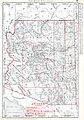 Arizona Territory Map, 1900.jpg 2,777 × 3,973; 4.5 MB
-
 Batchtown Map.JPG 3,888 × 2,592; 3.91 MB
-
 Bulletin - Biological Survey (1900) (19808427943).jpg 2,148 × 3,432; 1.41 MB
-
 Bulletin - Biological Survey (1900) (20241208558).jpg 3,536 × 2,244; 1.83 MB
-
 Bulletin - Biological Survey (1900) (20403086236).jpg 3,344 × 2,384; 1.69 MB
-

-
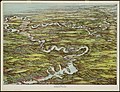 Charles River (2674608088).jpg 2,000 × 1,526; 3.85 MB
-
 County land ownership maps in the Library of Congress through 1900 LOC 85694778.jpg 8,433 × 6,480; 7.02 MB
-
 County land ownership maps in the Library of Congress through 1900 LOC 85694778.tif 8,433 × 6,480; 156.34 MB
-
 Dissected map of the United States. LOC 85697800.jpg 9,592 × 5,051; 6.72 MB
-

-
 Map of the borough of Manhattan, New York City. NYPL1528183.tiff 7,200 × 12,840; 264.53 MB
-
 Northern Pacific Railway map circa 1900 Western Washington.jpg 1,039 × 1,621; 1.93 MB
-

-

-
 Part of the metropolitan district (3855706539).jpg 2,000 × 1,400; 2.73 MB
-
 Philadelphia, Newtown and New York 1900.jpg 1,120 × 3,896; 886 KB
-
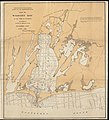 Plan of Waquoit Bay in the town of Falmouth (7557362448).jpg 3,940 × 4,320; 15.1 MB
-

-
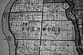
 Plat of proposed reservation at Fort Stevens, near Brightwood, D.C. LOC 88690824.jpg 4,370 × 5,721; 4.14 MB
-

-
 Solar eclipse 1900May28-map.png 642 × 478; 134 KB
-

-
 The Union Pacific system of railroad and steamship lines, 1900. LOC 98688841.jpg 7,927 × 5,993; 8.87 MB

.jpg)


_(19808427943).jpg)
_(20241208558).jpg)
_(20403086236).jpg)
_(20438965492).jpg)
.jpg)


.jpg)
.jpg)
.jpg)
.jpg)


_(14770734971).jpg)
