Category:1902 maps of the United States
States of the United States: California · Illinois · Indiana · Iowa · Kansas · Massachusetts · Michigan · Minnesota · Missouri · New Hampshire · New York · Ohio · Oklahoma · Pennsylvania · Texas · Virginia · Wisconsin – Washington, D.C.
| ← 1900 1901 1902 1903 1904 1905 1906 1907 1908 1909 → |
Subcategories
This category has the following 19 subcategories, out of 19 total.
C
D
- 1902 maps of Washington, D.C. (17 F)
I
- 1902 maps of Indiana (2 F)
K
M
- 1902 maps of Minnesota (7 F)
N
O
- 1902 maps of Oklahoma (2 F)
P
T
V
W
Media in category "1902 maps of the United States"
The following 15 files are in this category, out of 15 total.
-
 1902 map of Providence, Warren and Bristol Branch electrification.jpg 1,266 × 2,211; 243 KB
-
 1902 Squam Lake map.png 3,500 × 4,444; 22.71 MB
-
 A history of the American people (1902) (14781752572).jpg 1,772 × 2,768; 463 KB
-
 A history of the American people (1902) (14801956093).jpg 1,516 × 2,176; 401 KB
-
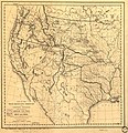
 A Map of the Burlington Route, 1902 - DPLA - 130554e69a6272dee4e9d60cf0ed893a.jpg 4,562 × 2,692; 2.68 MB
-

-

-
 Broad Canal, Cambridge (2674571136).jpg 2,000 × 444; 704 KB
-
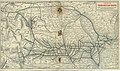
 Map of the Electric Railways leading from Worcester, Mass, 1902.jpg 1,170 × 911; 391 KB
-
-

-
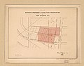 Plat showing proposed U.S. military reservation at Fort Stevens D.C.jpg 1,652 × 1,291; 187 KB
-

-

-


_(14781752572).jpg)
_(14801956093).jpg)


.jpg)
.jpg)